Property Record
9 Waterville Rd, Avon, CT 06001
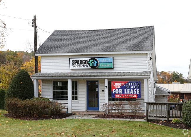

Property Detail
9 Waterville Rd
Hartford-West Hartford-East Hartford, CT
Capitol
AVON-000015-000000-000450-000009
Connecticut
Commercialnec
4500009
B and X Area of moderate flood hazard, usually the area between the limits of the 100-year and 500-year floods.
0.21 AC
2025
Avon
2025
Hartford
462202
NEARBY LISTINGS FOR SALE OR LEASE
DEMOGRAPHICS near 9 Waterville Rd
1 mile
3 mile
5 mile
2025 Total Population
2,404
19,598
82,057
2030 Population
2,461
20,087
83,967
Pop Growth 2025-2030
+ 2.37%
+ 2.50%
+ 2.33%
Average Age
45
44
43
2025 Total Households
1,000
7,774
32,932
HH Growth 2025-2030
+ 2.40%
+ 2.61%
+ 2.41%
Median Household Inc
$124,574
$143,107
$144,696
Avg Household Size
2.40
2.40
2.40
2025 Avg HH Vehicles
2.00
2.00
2.00
Median Home Value
$584,951
$466,576
$445,855
Median Year Built
1982
1974
1970
Nearby Places
Map Layers
Map Styles
 Street
 Aerial
Transit
 Traffic
 Biking
Places
Listings with unknown addresses are not visible on the map
- Restaurants
- Banks
- Shops
- Fitness
- Groceries
PUBLIC TRANSPORTATION
COMMUTER RAIL
Drive
Walk
Distance
14 min
8.4 mi
Drive
Walk
Distance
11 min
8.6 mi
AIRPORT
Bradley International
Drive
Walk
Distance
Bradley International
38 min
17.5 mi
SALE & LEASE HISTORY
LISTING DATE
SALE/LEASE

Sep 25, 2016
For Lease
Nov 02, 2020
For Lease
May 11, 2023
For Lease
Jun 30, 2021
For Lease
Jun 08, 2022
For Lease
Nearby Properties
Address
Land Use
TOTAL SIZE
Lot Size
Zoning
Address
Land Use
TOTAL SIZE
Lot Size
Zoning
39.86 AC
R40
Address
Land Use
TOTAL SIZE
Lot Size
Zoning
234.01 AC
EL
Address
Land Use
TOTAL SIZE
Lot Size
Zoning
35.44 AC
HSFBC
Address
Land Use
TOTAL SIZE
Lot Size
Zoning
26,928 SF
14.77 AC
PAD
Address
Land Use
TOTAL SIZE
Lot Size
Zoning
14.77 AC
R-40
Address
Land Use
TOTAL SIZE
Lot Size
Zoning
16.40 AC
B-3
Address
Land Use
TOTAL SIZE
Lot Size
Zoning
49,881 SF
18 AC
R-40
Address
Land Use
TOTAL SIZE
Lot Size
Zoning
18.52 AC
R40
Address
Land Use
TOTAL SIZE
Lot Size
Zoning
21.24 AC
R40
Address
Land Use
TOTAL SIZE
Lot Size
Zoning
46.60 AC
RU2A
Address
Land Use
TOTAL SIZE
Lot Size
Zoning
121,561 SF
4.56 AC
HSFBC
Address
Land Use
TOTAL SIZE
Lot Size
Zoning
21.86 AC
Address
Land Use
TOTAL SIZE
Lot Size
Zoning
48.90 AC
R-80
Address
Land Use
TOTAL SIZE
Lot Size
Zoning
18.05 AC
CR
Address
Land Use
TOTAL SIZE
Lot Size
Zoning
10.91 AC
AVC
Address
Land Use
TOTAL SIZE
Lot Size
Zoning
13.08 AC
CR
Address
Land Use
TOTAL SIZE
Lot Size
Zoning
21.06 AC
B-3
Address
Land Use
TOTAL SIZE
Lot Size
Zoning
112,351 SF
27.57 AC
RD
Address
Land Use
TOTAL SIZE
Lot Size
Zoning
61,272 SF
17.40 AC
R-13
Address
Land Use
TOTAL SIZE
Lot Size
Zoning
5.12 AC
Address
Land Use
TOTAL SIZE
Lot Size
Zoning
10 AC
RU2A
Address
Land Use
TOTAL SIZE
Lot Size
Zoning
6.57 AC
IP
Address
Land Use
TOTAL SIZE
Lot Size
Zoning
64,948 SF
9 AC
B-3
Address
Land Use
TOTAL SIZE
Lot Size
Zoning
20.11 AC
Address
Land Use
TOTAL SIZE
Lot Size
Zoning
4.02 AC
CP-A
Address
Land Use
TOTAL SIZE
Lot Size
Zoning
3.80 AC
Address
Land Use
TOTAL SIZE
Lot Size
Zoning
15.90 AC
R40
Address
Land Use
TOTAL SIZE
Lot Size
Zoning
126,889 SF
13.73 AC
I-1
Address
Land Use
TOTAL SIZE
Lot Size
Zoning
19.72 AC
RD
Address
Land Use
TOTAL SIZE
Lot Size
Zoning
8.73 AC
The World's #1 Commercial Real Estate Marketplace
Connect with us
© 2026 CoStar Group
The information above has been obtained from sources believed reliable. While we do not doubt its accuracy we have not verified it and make no guarantee, warranty or representation about it. It is your responsibility to independently confirm its accuracy and completeness. Any projections, opinions, assumptions, or estimates used are for example only and do not represent the current or future performance of the property. The value of this transaction to you depends on tax and other factors which should be evaluated by your tax, financial, and legal advisors. You and your advisors should conduct a careful, independent investigation of the property to determine to your satisfaction the suitability of the property for your needs.