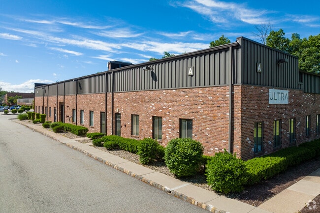
Property Record
9 Whippany Rd, Morristown, NJ 07960
NEARBY LISTINGS FOR SALE OR LEASE
Property Detail
9 Whippany Rd
Northern New Jersey
Centerline/Whippany River
Newark, NJ
Morris
12-05901-0000-00021
New Jersey
Industrialgeneral
21.1
2024
16 AC
2025
Eastern Morris
043301
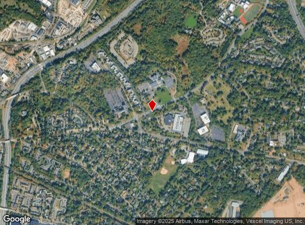
DEMOGRAPHICS near 9 Whippany Rd
1 Mile
3 Mile
5 Mile
2024 Total Population
4,384
39,870
169,473
2029 Population
4,401
39,903
169,375
Pop Growth 2024-2029
+ 0.39%
+ 0.08%
(0.06%)
Average Age
45
44
42
2024 Total Households
1,629
14,577
63,905
HH Growth 2024-2029
+ 0.31%
+ 0.05%
(0.01%)
Median Household Inc
$143,246
$138,594
$127,052
Avg Household Size
2.60
2.70
2.50
2024 Avg HH Vehicles
2.00
2.00
2.00
Median Home Value
$662,927
$631,566
$637,843
Median Year Built
1968
1973
1968
Nearby Places
Map Layers
Map Styles
 Street
 Aerial
- Restaurants
- Banks
- Shops
- Fitness
- Groceries
PUBLIC TRANSPORTATION
COMMUTER RAIL
Morristown (Morris & Essex Morristown Line - NJ Transit Commuter Rail (NJ Transit))
DRIVE
WALK
Distance
Morristown (Morris & Essex Morristown Line - NJ Transit Commuter Rail (NJ Transit))
1 min
19 min
1.0 mi
Convent Station (Morris & Essex Morristown Line - NJ Transit Commuter Rail (NJ Transit))
DRIVE
WALK
Distance
Convent Station (Morris & Essex Morristown Line - NJ Transit Commuter Rail (NJ Transit))
5 min
2.4 mi
AIRPORT
Newark Liberty International
DRIVE
WALK
Distance
Newark Liberty International
26 min
21.1 mi
Freight Ports
Maher Terminal
DRIVE
WALK
Distance
Maher Terminal
28 min
21.6 mi
SALE & LEASE HISTORY
LISTING DATE
SALE/LEASE

Sep 24, 2016
For Lease
May 14, 2018
For Lease
Feb 10, 2021
For Lease
Dec 13, 2024
For Lease
Dec 12, 2017
For Lease
Nearby Properties
Address
Land Use
TOTAL SIZE
Lot Size
Zoning
Address
Land Use
TOTAL SIZE
Lot Size
Zoning
66,201 SF
168.40 AC
R-3
Address
Land Use
TOTAL SIZE
Lot Size
Zoning
48.76 AC
OBRL
Address
Land Use
TOTAL SIZE
Lot Size
Zoning
596 SF
64.81 AC
OBRL
Address
Land Use
TOTAL SIZE
Lot Size
Zoning
23.01 AC
R-2
Address
Land Use
TOTAL SIZE
Lot Size
Zoning
64.80 AC
C-4
Address
Land Use
TOTAL SIZE
Lot Size
Zoning
72,698 SF
133.64 AC
U
Address
Land Use
TOTAL SIZE
Lot Size
Zoning
1.55 AC
Address
Land Use
TOTAL SIZE
Lot Size
Zoning
50.01 AC
PCDO
Address
Land Use
TOTAL SIZE
Lot Size
Zoning
2.82 AC
Address
Land Use
TOTAL SIZE
Lot Size
Zoning
270,000 SF
15.32 AC
OR
Address
Land Use
TOTAL SIZE
Lot Size
Zoning
13,428 SF
108.84 AC
OSGU
Address
Land Use
TOTAL SIZE
Lot Size
Zoning
396,029 SF
40.08 AC
OL40
Address
Land Use
TOTAL SIZE
Lot Size
Zoning
10.94 AC
Address
Land Use
TOTAL SIZE
Lot Size
Zoning
8.64 AC
RG
Address
Land Use
TOTAL SIZE
Lot Size
Zoning
43.60 AC
C-4
Address
Land Use
TOTAL SIZE
Lot Size
Zoning
Address
Land Use
TOTAL SIZE
Lot Size
Zoning
18.42 AC
RM
Address
Land Use
TOTAL SIZE
Lot Size
Zoning
0.36 AC
UR
Address
Land Use
TOTAL SIZE
Lot Size
Zoning
13.10 AC
R-25
Address
Land Use
TOTAL SIZE
Lot Size
Zoning
10.42 AC
Address
Land Use
TOTAL SIZE
Lot Size
Zoning
27.20 AC
PODS
Address
Land Use
TOTAL SIZE
Lot Size
Zoning
304,213 SF
21.73 AC
PODS
Address
Land Use
TOTAL SIZE
Lot Size
Zoning
46.46 AC
B-3
Address
Land Use
TOTAL SIZE
Lot Size
Zoning
34.13 AC
OB
Address
Land Use
TOTAL SIZE
Lot Size
Zoning
3.13 AC
CBD
Address
Land Use
TOTAL SIZE
Lot Size
Zoning
14.50 AC
RG
Address
Land Use
TOTAL SIZE
Lot Size
Zoning
38.86 AC
L
Address
Land Use
TOTAL SIZE
Lot Size
Zoning
0.57 AC
CBD
Address
Land Use
TOTAL SIZE
Lot Size
Zoning
88,345 SF
15.67 AC
R-7
Address
Land Use
TOTAL SIZE
Lot Size
Zoning
0.41 AC
UR
The World's #1 Commercial Real Estate Marketplace
Connect with us
© 2026 CoStar Group
The information above has been obtained from sources believed reliable. While we do not doubt its accuracy we have not verified it and make no guarantee, warranty or representation about it. It is your responsibility to independently confirm its accuracy and completeness. Any projections, opinions, assumptions, or estimates used are for example only and do not represent the current or future performance of the property. The value of this transaction to you depends on tax and other factors which should be evaluated by your tax, financial, and legal advisors. You and your advisors should conduct a careful, independent investigation of the property to determine to your satisfaction the suitability of the property for your needs.