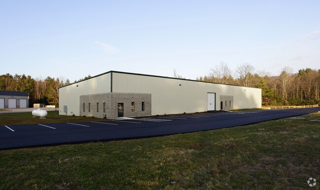
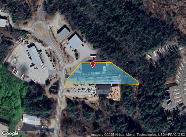
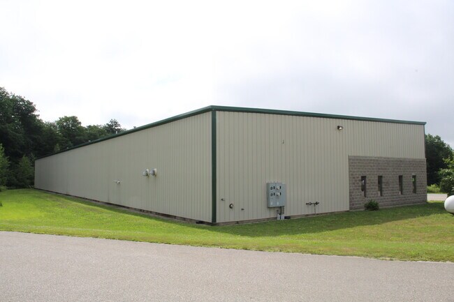
Property Record
9 Willey Rd, Saco, ME 04072
NEARBY LISTINGS FOR SALE OR LEASE
Property Detail
9 Willey Rd
SACO-000073-000014
York
Industrialgeneral
Maine
X
14
23031C0316G
2.29 AC
2024
York County
2024
Portland/South Portland
005200
Portland-South Portland, ME
14,625 SF
DEMOGRAPHICS near 9 Willey Rd
1 Mile
3 Mile
5 Mile
2024 Total Population
733
25,251
57,252
2029 Population
758
26,808
60,691
Pop Growth 2024-2029
+ 3.41%
+ 6.17%
+ 6.01%
Average Age
42
44
43
2024 Total Households
313
11,492
25,589
HH Growth 2024-2029
+ 3.19%
+ 6.24%
+ 6.23%
Median Household Inc
$73,874
$68,752
$67,426
Avg Household Size
2.20
2.10
2.20
2024 Avg HH Vehicles
2.00
2.00
2.00
Median Home Value
$319,711
$313,025
$339,292
Median Year Built
1983
1984
1978
Nearby Places
Map Layers
Map Styles
 Street
 Aerial
- Restaurants
- Banks
- Shops
- Fitness
- Groceries
PUBLIC TRANSPORTATION
COMMUTER RAIL
DRIVE
WALK
Distance
9 min
4.3 mi
DRIVE
WALK
Distance
9 min
4.8 mi
AIRPORT
Portland International Jetport
DRIVE
WALK
Distance
Portland International Jetport
23 min
14.2 mi
SALE & LEASE HISTORY
LISTING DATE
SALE/LEASE

Sep 08, 2017
For Sale
May 27, 2022
For Lease
Aug 06, 2020
For Sale
Aug 03, 2017
For Lease
Nearby Properties
Address
Land Use
TOTAL SIZE
Lot Size
Zoning
Address
Land Use
TOTAL SIZE
Lot Size
Zoning
10 AC
B-4
Address
Land Use
TOTAL SIZE
Lot Size
Zoning
141.57 AC
I-1
Address
Land Use
TOTAL SIZE
Lot Size
Zoning
Address
Land Use
TOTAL SIZE
Lot Size
Zoning
27.50 AC
R-1B
Address
Land Use
TOTAL SIZE
Lot Size
Zoning
2,295.68 AC
B-6
Address
Land Use
TOTAL SIZE
Lot Size
Zoning
7.86 AC
B2A
Address
Land Use
TOTAL SIZE
Lot Size
Zoning
2,637 SF
81.33 AC
MZ
Address
Land Use
TOTAL SIZE
Lot Size
Zoning
Address
Land Use
TOTAL SIZE
Lot Size
Zoning
2.50 AC
R-1
Address
Land Use
TOTAL SIZE
Lot Size
Zoning
Address
Land Use
TOTAL SIZE
Lot Size
Zoning
11.40 AC
B-1
Address
Land Use
TOTAL SIZE
Lot Size
Zoning
708 SF
52.01 AC
R-4
Address
Land Use
TOTAL SIZE
Lot Size
Zoning
62,610 SF
2.61 AC
R-1A
Address
Land Use
TOTAL SIZE
Lot Size
Zoning
110 AC
R-1D
Address
Land Use
TOTAL SIZE
Lot Size
Zoning
52,582 SF
12.58 AC
B-6
Address
Land Use
TOTAL SIZE
Lot Size
Zoning
3,033 SF
55.01 AC
RD
Address
Land Use
TOTAL SIZE
Lot Size
Zoning
35,714 SF
39.79 AC
MU3
Address
Land Use
TOTAL SIZE
Lot Size
Zoning
63,300 SF
11.76 AC
B-2D
Address
Land Use
TOTAL SIZE
Lot Size
Zoning
124,800 SF
30.53 AC
Address
Land Use
TOTAL SIZE
Lot Size
Zoning
104.72 AC
B-6
Address
Land Use
TOTAL SIZE
Lot Size
Zoning
4,296 SF
27.94 AC
MZ
Address
Land Use
TOTAL SIZE
Lot Size
Zoning
47,532 SF
4.76 AC
MZ
Address
Land Use
TOTAL SIZE
Lot Size
Zoning
127,292 SF
12.55 AC
I-1
Address
Land Use
TOTAL SIZE
Lot Size
Zoning
75,288 SF
6.27 AC
Address
Land Use
TOTAL SIZE
Lot Size
Zoning
7,216 SF
10.40 AC
MZ
Address
Land Use
TOTAL SIZE
Lot Size
Zoning
5,000 SF
8.30 AC
PMUD
Address
Land Use
TOTAL SIZE
Lot Size
Zoning
80,064 SF
9.80 AC
R-1B
Address
Land Use
TOTAL SIZE
Lot Size
Zoning
41,036 SF
0.68 AC
B-3
Address
Land Use
TOTAL SIZE
Lot Size
Zoning
39,552 SF
56.22 AC
B-6
Address
Land Use
TOTAL SIZE
Lot Size
Zoning
84,274 SF
24 AC
I-2
The World's #1 Commercial Real Estate Marketplace
Connect with us
© 2026 CoStar Group
The information above has been obtained from sources believed reliable. While we do not doubt its accuracy we have not verified it and make no guarantee, warranty or representation about it. It is your responsibility to independently confirm its accuracy and completeness. Any projections, opinions, assumptions, or estimates used are for example only and do not represent the current or future performance of the property. The value of this transaction to you depends on tax and other factors which should be evaluated by your tax, financial, and legal advisors. You and your advisors should conduct a careful, independent investigation of the property to determine to your satisfaction the suitability of the property for your needs.