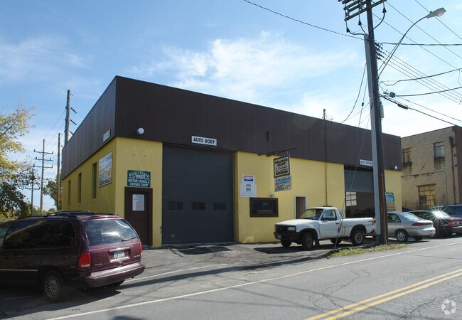
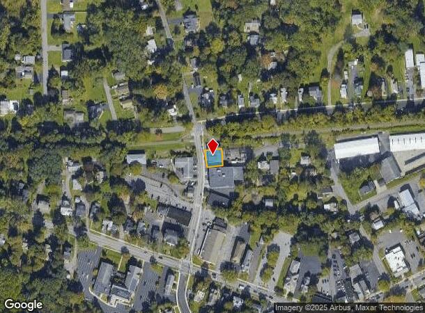
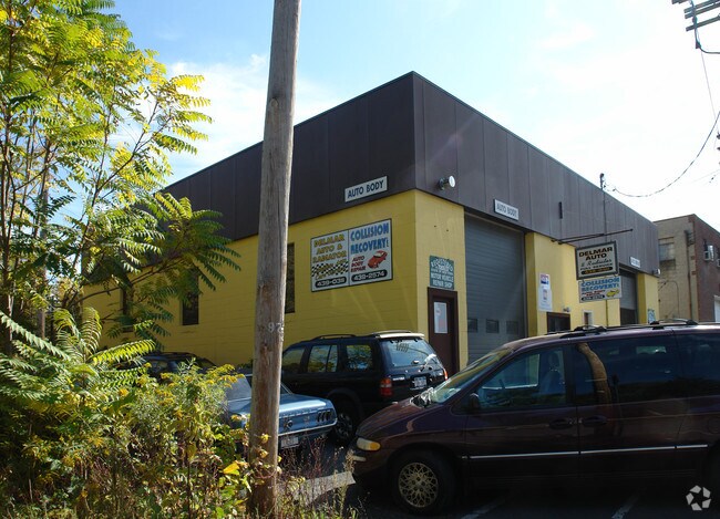
Property Record
90 Adams St, Delmar, NY 12054
NEARBY LISTINGS FOR SALE OR LEASE
Property Detail
90 Adams St
012200-085-012-0003-016-000-0000
DELMAR
Warehouse
Albany
X
New York
36001C0302D
16.000
2025
0.10 AC
2024
W Outer Albany County
014202
Albany/Schenectady/Troy
3,360 SF
Albany-Schenectady-Troy, NY
DEMOGRAPHICS near 90 Adams St
1 Mile
3 Mile
5 Mile
2024 Total Population
7,834
43,692
143,314
2029 Population
7,770
43,277
141,910
Pop Growth 2024-2029
(0.82%)
(0.95%)
(0.98%)
Average Age
44
43
38
2024 Total Households
3,241
18,645
59,773
HH Growth 2024-2029
(0.77%)
(0.92%)
(0.99%)
Median Household Inc
$107,105
$95,899
$68,175
Avg Household Size
2.30
2.30
2.10
2024 Avg HH Vehicles
2.00
2.00
1.00
Median Home Value
$301,609
$280,943
$255,517
Median Year Built
1952
1965
1956
Nearby Places
- Restaurants
- Banks
- Shops
- Fitness
- Groceries
PUBLIC TRANSPORTATION
COMMUTER RAIL
DRIVE
WALK
Distance
13 min
6.0 mi
AIRPORT
Albany International
DRIVE
WALK
Distance
Albany International
26 min
15.3 mi
Freight Ports
Albany, NY Port
DRIVE
WALK
Distance
Albany, NY Port
12 min
5.4 mi
Nearby Properties
Address
Land Use
TOTAL SIZE
Lot Size
Zoning
Address
Land Use
TOTAL SIZE
Lot Size
Zoning
502,950 SF
12.50 AC
CO
Address
Land Use
TOTAL SIZE
Lot Size
Zoning
133,984 SF
205.20 AC
C2
Address
Land Use
TOTAL SIZE
Lot Size
Zoning
9,208 SF
290.80 AC
LC
Address
Land Use
TOTAL SIZE
Lot Size
Zoning
191.95 AC
LC
Address
Land Use
TOTAL SIZE
Lot Size
Zoning
5,248 SF
200.90 AC
LC
Address
Land Use
TOTAL SIZE
Lot Size
Zoning
78,458 SF
28.70 AC
R1B
Address
Land Use
TOTAL SIZE
Lot Size
Zoning
441,152 SF
3.32 AC
CO
Address
Land Use
TOTAL SIZE
Lot Size
Zoning
349,516 SF
22.61 AC
MED
Address
Land Use
TOTAL SIZE
Lot Size
Zoning
65,219 SF
35 AC
R1B
Address
Land Use
TOTAL SIZE
Lot Size
Zoning
59,442 SF
69.20 AC
R1LL
Address
Land Use
TOTAL SIZE
Lot Size
Zoning
315,680 SF
73.80 AC
RA
Address
Land Use
TOTAL SIZE
Lot Size
Zoning
96,554 SF
18.50 AC
R1B
Address
Land Use
TOTAL SIZE
Lot Size
Zoning
58.90 AC
LC
Address
Land Use
TOTAL SIZE
Lot Size
Zoning
18,390 SF
15.52 AC
PDD
Address
Land Use
TOTAL SIZE
Lot Size
Zoning
89,373 SF
3 AC
R3A
Address
Land Use
TOTAL SIZE
Lot Size
Zoning
39,449 SF
3.80 AC
R3A
Address
Land Use
TOTAL SIZE
Lot Size
Zoning
203,781 SF
39.30 AC
C
Address
Land Use
TOTAL SIZE
Lot Size
Zoning
143,970 SF
2.40 AC
R1B
Address
Land Use
TOTAL SIZE
Lot Size
Zoning
16,739 SF
14.20 AC
PDD
Address
Land Use
TOTAL SIZE
Lot Size
Zoning
7,472 SF
18.40 AC
PDD
Address
Land Use
TOTAL SIZE
Lot Size
Zoning
96,218 SF
4.30 AC
CO
Address
Land Use
TOTAL SIZE
Lot Size
Zoning
204,860 SF
26.40 AC
CR
Address
Land Use
TOTAL SIZE
Lot Size
Zoning
45,898 SF
12.91 AC
CH
Address
Land Use
TOTAL SIZE
Lot Size
Zoning
57,691 SF
19.70 AC
CO
Address
Land Use
TOTAL SIZE
Lot Size
Zoning
5,587 SF
48.83 AC
PDD
Address
Land Use
TOTAL SIZE
Lot Size
Zoning
86,664 SF
1.96 AC
R2A
Address
Land Use
TOTAL SIZE
Lot Size
Zoning
140,609 SF
14.50 AC
CR
Address
Land Use
TOTAL SIZE
Lot Size
Zoning
44,097 SF
9 AC
CH
Address
Land Use
TOTAL SIZE
Lot Size
Zoning
121,323 SF
13.54 AC
CH
Address
Land Use
TOTAL SIZE
Lot Size
Zoning
9,120 SF
12.95 AC
H
The World's #1 Commercial Real Estate Marketplace
Connect with us
© 2025 CoStar Group
The information above has been obtained from sources believed reliable. While we do not doubt its accuracy we have not verified it and make no guarantee, warranty or representation about it. It is your responsibility to independently confirm its accuracy and completeness. Any projections, opinions, assumptions, or estimates used are for example only and do not represent the current or future performance of the property. The value of this transaction to you depends on tax and other factors which should be evaluated by your tax, financial, and legal advisors. You and your advisors should conduct a careful, independent investigation of the property to determine to your satisfaction the suitability of the property for your needs.