Property Record
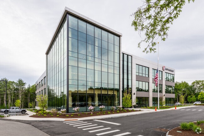
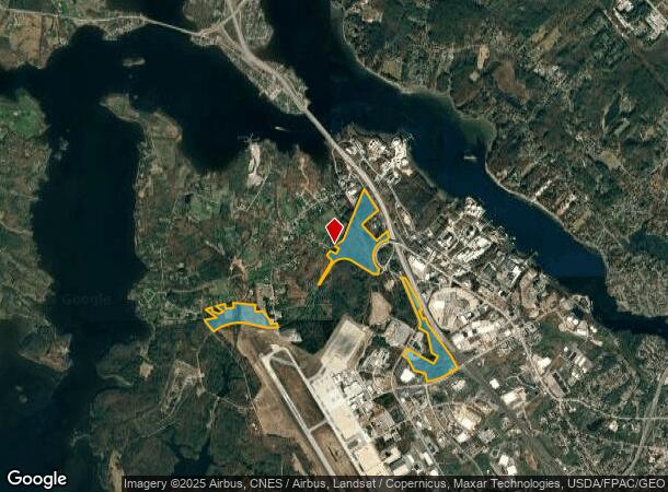
Pease Blvd, Portsmouth, NH 03801
Current Lease Availabilities
NEARBY LISTINGS FOR SALE OR LEASE
Property Detail
Pease Blvd
Taxexempt
Rockingham
X
New Hampshire
33015C0360E
Rockingham
0
Boston
2024
Boston-Cambridge-Newton, MA-NH
069200
PRSM-000319
2,304 SF
DEMOGRAPHICS near Pease Blvd
1 Mile
3 Mile
5 Mile
2024 Total Population
364
18,654
43,715
2029 Population
374
19,570
45,722
Pop Growth 2024-2029
+ 2.75%
+ 4.91%
+ 4.59%
Average Age
40
43
44
2024 Total Households
167
8,768
19,623
HH Growth 2024-2029
+ 2.40%
+ 4.89%
+ 4.57%
Median Household Inc
$47,500
$97,932
$100,703
Avg Household Size
2.20
2.10
2.20
2024 Avg HH Vehicles
1.00
2.00
2.00
Median Home Value
$382,758
$538,543
$526,082
Median Year Built
1982
1959
1969
Nearby Places
- Restaurants
- Banks
- Shops
- Fitness
- Groceries
PUBLIC TRANSPORTATION
COMMUTER RAIL
Durham (Downeaster - Amtrak)
DRIVE
WALK
Distance
Durham (Downeaster - Amtrak)
19 min
9.0 mi
Dover (Downeaster - Amtrak)
DRIVE
WALK
Distance
Dover (Downeaster - Amtrak)
17 min
9.1 mi
AIRPORT
Portsmouth International at Pease
DRIVE
WALK
Distance
Portsmouth International at Pease
9 min
4.0 mi
Freight Ports
Portland, ME
DRIVE
WALK
Distance
Portland, ME
67 min
56.3 mi
Nearby Properties
Address
Land Use
TOTAL SIZE
Lot Size
Zoning
Address
Land Use
TOTAL SIZE
Lot Size
Zoning
58.25 AC
COMM
Address
Land Use
TOTAL SIZE
Lot Size
Zoning
1,575 SF
52.95 AC
COMM
Address
Land Use
TOTAL SIZE
Lot Size
Zoning
19.26 AC
G1
Address
Land Use
TOTAL SIZE
Lot Size
Zoning
11.30 AC
G1
Address
Land Use
TOTAL SIZE
Lot Size
Zoning
15.94 AC
G1
Address
Land Use
TOTAL SIZE
Lot Size
Zoning
48.95 AC
WIND
Address
Land Use
TOTAL SIZE
Lot Size
Zoning
3.78 AC
COMM
Address
Land Use
TOTAL SIZE
Lot Size
Zoning
127,896 SF
20.32 AC
ABC
Address
Land Use
TOTAL SIZE
Lot Size
Zoning
205,891 SF
LI
Address
Land Use
TOTAL SIZE
Lot Size
Zoning
64.76 AC
WIND
Address
Land Use
TOTAL SIZE
Lot Size
Zoning
18.49 AC
GRB
Address
Land Use
TOTAL SIZE
Lot Size
Zoning
23.29 AC
G1
Address
Land Use
TOTAL SIZE
Lot Size
Zoning
17.11 AC
ABC
Address
Land Use
TOTAL SIZE
Lot Size
Zoning
137,809 SF
13.18 AC
ABC
Address
Land Use
TOTAL SIZE
Lot Size
Zoning
204,800 SF
ABC
Address
Land Use
TOTAL SIZE
Lot Size
Zoning
3.97 AC
SD
Address
Land Use
TOTAL SIZE
Lot Size
Zoning
9,060 SF
7.02 AC
IND
Address
Land Use
TOTAL SIZE
Lot Size
Zoning
70,555 SF
9.81 AC
ABC
Address
Land Use
TOTAL SIZE
Lot Size
Zoning
39,780 SF
8.82 AC
OR
Address
Land Use
TOTAL SIZE
Lot Size
Zoning
126,280 SF
28.92 AC
ABC
Address
Land Use
TOTAL SIZE
Lot Size
Zoning
5.45 AC
OFF
Address
Land Use
TOTAL SIZE
Lot Size
Zoning
117,028 SF
12.25 AC
G1
Address
Land Use
TOTAL SIZE
Lot Size
Zoning
238,513 SF
31.02 AC
COMM
Address
Land Use
TOTAL SIZE
Lot Size
Zoning
81,964 SF
6.99 AC
OR
Address
Land Use
TOTAL SIZE
Lot Size
Zoning
129,262 SF
PDA
Address
Land Use
TOTAL SIZE
Lot Size
Zoning
65,550 SF
10 AC
ABC
Address
Land Use
TOTAL SIZE
Lot Size
Zoning
Address
Land Use
TOTAL SIZE
Lot Size
Zoning
101,643 SF
8.41 AC
OFF
Address
Land Use
TOTAL SIZE
Lot Size
Zoning
63,087 SF
1.83 AC
G1
Address
Land Use
TOTAL SIZE
Lot Size
Zoning
45,824 SF
7.36 AC
ABC
The World's #1 Commercial Real Estate Marketplace
Connect with us
© 2025 CoStar Group
The information above has been obtained from sources believed reliable. While we do not doubt its accuracy we have not verified it and make no guarantee, warranty or representation about it. It is your responsibility to independently confirm its accuracy and completeness. Any projections, opinions, assumptions, or estimates used are for example only and do not represent the current or future performance of the property. The value of this transaction to you depends on tax and other factors which should be evaluated by your tax, financial, and legal advisors. You and your advisors should conduct a careful, independent investigation of the property to determine to your satisfaction the suitability of the property for your needs.