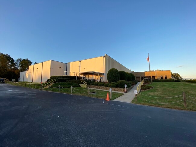
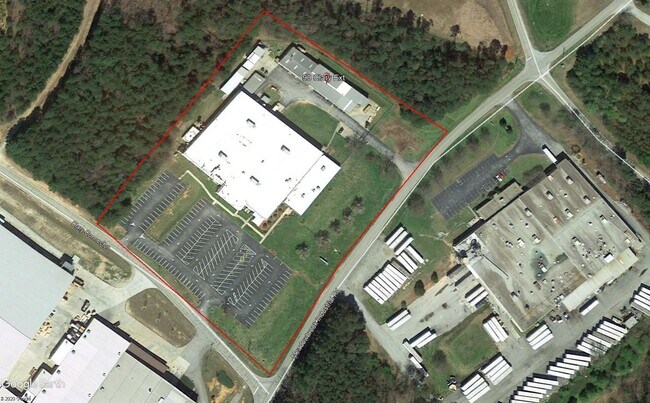
Property Record
90 Clary Connector Ext, Eastanollee, GA 30538
NEARBY LISTINGS FOR SALE OR LEASE
Property Detail
90 Clary Connector Ext
044-174
8500 - Primary - Ac
Manufacturinglight
PARCEL A MEADOWBROOK DR
X
Stephens
13257C0118D
Georgia
2025
7.68 AC
2025
Georgia Northeast
970401
Other Market Areas
67,353 SF
Toccoa, GA
DEMOGRAPHICS near 90 Clary Connector Ext
1 Mile
3 Mile
5 Mile
2024 Total Population
254
6,396
18,676
2029 Population
258
6,511
19,092
Pop Growth 2024-2029
+ 1.57%
+ 1.80%
+ 2.23%
Average Age
42
42
42
2024 Total Households
99
2,551
7,484
HH Growth 2024-2029
+ 2.02%
+ 1.49%
+ 2.02%
Median Household Inc
$71,249
$50,678
$49,036
Avg Household Size
2.50
2.50
2.40
2024 Avg HH Vehicles
3.00
2.00
2.00
Median Home Value
$162,903
$150,987
$148,724
Median Year Built
1987
1982
1980
Nearby Places
Map Layers
Map Styles
 Street
 Aerial
- Restaurants
- Banks
- Shops
- Fitness
- Groceries
PUBLIC TRANSPORTATION
COMMUTER RAIL
Toccoa Amtrak Station (Crescent - Amtrak)
DRIVE
WALK
Distance
Toccoa Amtrak Station (Crescent - Amtrak)
10 min
6.7 mi
Freight Ports
Georgia Ports - Savannah
DRIVE
WALK
Distance
Georgia Ports - Savannah
302 min
245.7 mi
SALE & LEASE HISTORY
LISTING DATE
SALE/LEASE

Dec 17, 2020
For Sale
Nearby Properties
Address
Land Use
TOTAL SIZE
Lot Size
Zoning
Address
Land Use
TOTAL SIZE
Lot Size
Zoning
3.47 AC
CI
Address
Land Use
TOTAL SIZE
Lot Size
Zoning
218,215 SF
25.17 AC
CG
Address
Land Use
TOTAL SIZE
Lot Size
Zoning
391,121 SF
62.73 AC
CG
Address
Land Use
TOTAL SIZE
Lot Size
Zoning
52,140 SF
115.88 AC
CG
Address
Land Use
TOTAL SIZE
Lot Size
Zoning
4.24 AC
M-I
Address
Land Use
TOTAL SIZE
Lot Size
Zoning
192,404 SF
27.79 AC
B-II
Address
Land Use
TOTAL SIZE
Lot Size
Zoning
Address
Land Use
TOTAL SIZE
Lot Size
Zoning
61,105 SF
64.49 AC
CG
Address
Land Use
TOTAL SIZE
Lot Size
Zoning
0.58 AC
CI
Address
Land Use
TOTAL SIZE
Lot Size
Zoning
148,256 SF
24.53 AC
CI
Address
Land Use
TOTAL SIZE
Lot Size
Zoning
68,998 SF
24.53 AC
CG
Address
Land Use
TOTAL SIZE
Lot Size
Zoning
75,274 SF
39.40 AC
CG
Address
Land Use
TOTAL SIZE
Lot Size
Zoning
23,193 SF
5.89 AC
CG
Address
Land Use
TOTAL SIZE
Lot Size
Zoning
13,568 SF
7.50 AC
B-II
Address
Land Use
TOTAL SIZE
Lot Size
Zoning
123,520 SF
25.28 AC
CI
Address
Land Use
TOTAL SIZE
Lot Size
Zoning
111,150 SF
5.91 AC
CI
Address
Land Use
TOTAL SIZE
Lot Size
Zoning
39,460 SF
8.20 AC
B-II
Address
Land Use
TOTAL SIZE
Lot Size
Zoning
34,170 SF
12.91 AC
CG
Address
Land Use
TOTAL SIZE
Lot Size
Zoning
21,332 SF
147.93 AC
CI
Address
Land Use
TOTAL SIZE
Lot Size
Zoning
Address
Land Use
TOTAL SIZE
Lot Size
Zoning
32,440 SF
81.75 AC
R-IA
Address
Land Use
TOTAL SIZE
Lot Size
Zoning
Address
Land Use
TOTAL SIZE
Lot Size
Zoning
167,500 SF
20.98 AC
CI
Address
Land Use
TOTAL SIZE
Lot Size
Zoning
131,717 SF
23.47 AC
CI
Address
Land Use
TOTAL SIZE
Lot Size
Zoning
27,013 SF
3.25 AC
R-IA
Address
Land Use
TOTAL SIZE
Lot Size
Zoning
375 AC
LI
Address
Land Use
TOTAL SIZE
Lot Size
Zoning
50,225 SF
17 AC
B-II
Address
Land Use
TOTAL SIZE
Lot Size
Zoning
5,100 SF
5.75 AC
CI
Address
Land Use
TOTAL SIZE
Lot Size
Zoning
176,000 SF
16.59 AC
CI
Address
Land Use
TOTAL SIZE
Lot Size
Zoning
16,872 SF
2.53 AC
B-II
The World's #1 Commercial Real Estate Marketplace
Connect with us
© 2026 CoStar Group
The information above has been obtained from sources believed reliable. While we do not doubt its accuracy we have not verified it and make no guarantee, warranty or representation about it. It is your responsibility to independently confirm its accuracy and completeness. Any projections, opinions, assumptions, or estimates used are for example only and do not represent the current or future performance of the property. The value of this transaction to you depends on tax and other factors which should be evaluated by your tax, financial, and legal advisors. You and your advisors should conduct a careful, independent investigation of the property to determine to your satisfaction the suitability of the property for your needs.