Property Record
90 Dart Cir, Rome, NY 13441
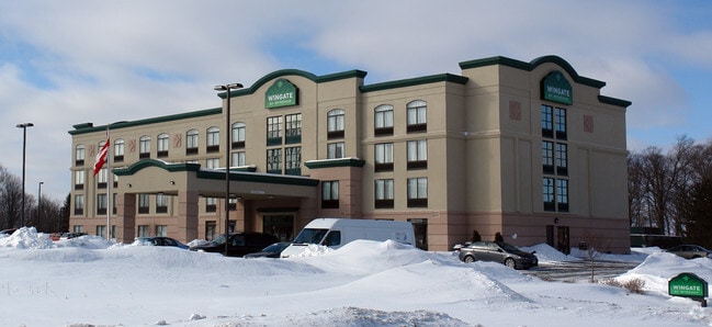

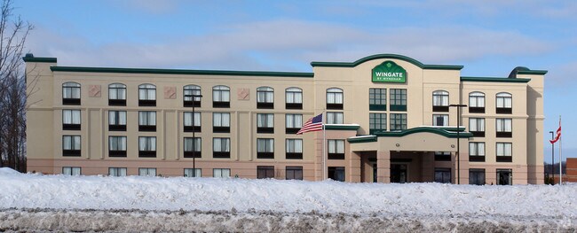
Property Detail
90 Dart Cir
243-000-0001-001-018-0000
Oneida
Hotel
New York
GB
1.018
B and X Area of moderate flood hazard, usually the area between the limits of the 100-year and 500-year floods.
3 AC
0
Central New York Area/Thousand Island
2025
Utica/Rome
022500
Utica-Rome, NY
47,173 SF
NEARBY LISTINGS FOR SALE OR LEASE
-
-
View all Rome listings for sale on LoopNet.com
DEMOGRAPHICS near 90 Dart Cir
1 mile
3 mile
5 mile
2025 Total Population
2,169
24,235
35,740
2030 Population
2,224
24,201
35,655
Pop Growth 2025-2030
+ 2.54%
(0.14%)
(0.24%)
Average Age
35
41
42
2025 Total Households
923
10,586
14,772
HH Growth 2025-2030
+ 2.38%
(0.37%)
(0.40%)
Median Household Inc
$48,610
$49,643
$56,069
Avg Household Size
2.20
2.20
2.20
2025 Avg HH Vehicles
2.00
1.00
2.00
Median Home Value
$129,389
$148,458
$159,399
Median Year Built
1970
1952
1955
Nearby Places
Map Layers
Map Styles
 Street
 Aerial
Layers
 Traffic
 Biking
Places
Listings with unknown addresses are not visible on the map
- Restaurants
- Banks
- Shops
- Fitness
- Groceries
PUBLIC TRANSPORTATION
COMMUTER RAIL
Drive
Walk
Distance
6 min
2.7 mi
Nearby Properties
Address
Land Use
TOTAL SIZE
Lot Size
Zoning
Address
Land Use
TOTAL SIZE
Lot Size
Zoning
261,699 SF
7.70 AC
I
Address
Land Use
TOTAL SIZE
Lot Size
Zoning
16,970 SF
1,263.52 AC
GB
Address
Land Use
TOTAL SIZE
Lot Size
Zoning
273,250 SF
78.37 AC
GB
Address
Land Use
TOTAL SIZE
Lot Size
Zoning
70,000 SF
126.93 AC
GB
Address
Land Use
TOTAL SIZE
Lot Size
Zoning
70,000 SF
126.93 AC
GB
Address
Land Use
TOTAL SIZE
Lot Size
Zoning
777,552 SF
63.78 AC
GB
Address
Land Use
TOTAL SIZE
Lot Size
Zoning
25,110 SF
51.76 AC
AG
Address
Land Use
TOTAL SIZE
Lot Size
Zoning
918,608 SF
86.69 AC
GB
Address
Land Use
TOTAL SIZE
Lot Size
Zoning
11,842 SF
18.34 AC
GB
Address
Land Use
TOTAL SIZE
Lot Size
Zoning
78,658 SF
1.92 AC
AG
Address
Land Use
TOTAL SIZE
Lot Size
Zoning
385,216 SF
30.87 AC
GB
Address
Land Use
TOTAL SIZE
Lot Size
Zoning
10.50 AC
NA
Address
Land Use
TOTAL SIZE
Lot Size
Zoning
77,604 SF
4.34 AC
GB
Address
Land Use
TOTAL SIZE
Lot Size
Zoning
80 AC
GB
Address
Land Use
TOTAL SIZE
Lot Size
Zoning
195,839 SF
22.69 AC
GB
Address
Land Use
TOTAL SIZE
Lot Size
Zoning
60,450 SF
2.95 AC
R-P
Address
Land Use
TOTAL SIZE
Lot Size
Zoning
150,113 SF
12.17 AC
GB
Address
Land Use
TOTAL SIZE
Lot Size
Zoning
58,560 SF
2.44 AC
R-P
Address
Land Use
TOTAL SIZE
Lot Size
Zoning
112,259 SF
2.59 AC
C-3
Address
Land Use
TOTAL SIZE
Lot Size
Zoning
10,836 SF
11.24 AC
R-3
Address
Land Use
TOTAL SIZE
Lot Size
Zoning
6,104 SF
123.23 AC
GB
Address
Land Use
TOTAL SIZE
Lot Size
Zoning
131,001 SF
14.70 AC
R-2
Address
Land Use
TOTAL SIZE
Lot Size
Zoning
173,579 SF
14.46 AC
R-1-8
Address
Land Use
TOTAL SIZE
Lot Size
Zoning
41,262 SF
16.30 AC
R-1-8
Address
Land Use
TOTAL SIZE
Lot Size
Zoning
113,024 SF
10.39 AC
GB
Address
Land Use
TOTAL SIZE
Lot Size
Zoning
8,430 SF
60.20 AC
Address
Land Use
TOTAL SIZE
Lot Size
Zoning
72,388 SF
0.60 AC
C-3
Address
Land Use
TOTAL SIZE
Lot Size
Zoning
49,643 SF
8 AC
C-1
Address
Land Use
TOTAL SIZE
Lot Size
Zoning
2,630 SF
13.09 AC
R-3
Address
Land Use
TOTAL SIZE
Lot Size
Zoning
3,778 SF
15.52 AC
OS
The World's #1 Commercial Real Estate Marketplace
Connect with us
© 2026 CoStar Group
The information above has been obtained from sources believed reliable. While we do not doubt its accuracy we have not verified it and make no guarantee, warranty or representation about it. It is your responsibility to independently confirm its accuracy and completeness. Any projections, opinions, assumptions, or estimates used are for example only and do not represent the current or future performance of the property. The value of this transaction to you depends on tax and other factors which should be evaluated by your tax, financial, and legal advisors. You and your advisors should conduct a careful, independent investigation of the property to determine to your satisfaction the suitability of the property for your needs.