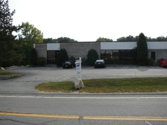
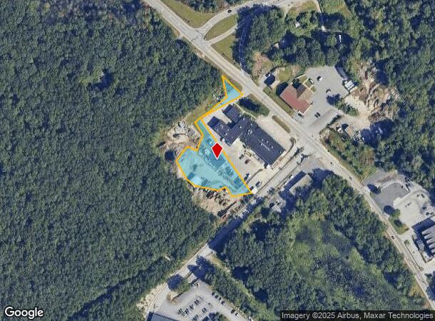
Property Record
90 Douglas Pike, Smithfield, RI 02917
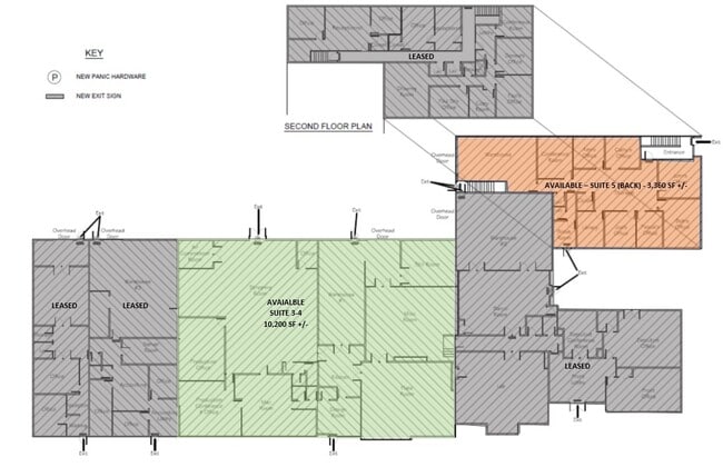
Current Lease Availabilities
NEARBY LISTINGS FOR SALE OR LEASE
Property Detail
90 Douglas Pike
SMIT-000040-000000-000441
Providence
Industrialgeneral
Rhode Island
X
452
44007C0301H
4.50 AC
2025
Smithfield
2025
Providence
012602
Providence-Warwick, RI-MA
2,688 SF
DEMOGRAPHICS near 90 Douglas Pike
1 Mile
3 Mile
5 Mile
2024 Total Population
5,216
71,833
270,543
2029 Population
5,251
71,658
268,383
Pop Growth 2024-2029
+ 0.67%
(0.24%)
(0.80%)
Average Age
46
42
39
2024 Total Households
2,357
30,382
107,030
HH Growth 2024-2029
+ 0.64%
(0.32%)
(0.77%)
Median Household Inc
$84,966
$75,191
$66,764
Avg Household Size
2.20
2.30
2.40
2024 Avg HH Vehicles
2.00
2.00
2.00
Median Home Value
$353,912
$307,533
$307,864
Median Year Built
1983
1967
1955
Nearby Places
Map Layers
Map Styles
 Street
 Aerial
- Restaurants
- Banks
- Shops
- Fitness
- Groceries
PUBLIC TRANSPORTATION
COMMUTER RAIL
Pawtucket/Central Falls (Foxboro Event Service - MBTA, Providence/Stoughton Line - MBTA)
DRIVE
WALK
Distance
Pawtucket/Central Falls (Foxboro Event Service - MBTA, Providence/Stoughton Line - MBTA)
9 min
5.1 mi
Providence (Providence/Stoughton Line - Massachusetts Bay Transportation Authority Commuter Rail (Purple Line))
DRIVE
WALK
Distance
Providence (Providence/Stoughton Line - Massachusetts Bay Transportation Authority Commuter Rail (Purple Line))
9 min
5.8 mi
AIRPORT
Rhode Island Tf Green International
DRIVE
WALK
Distance
Rhode Island Tf Green International
25 min
14.0 mi
Freight Ports
Port of Davisville, RI
DRIVE
WALK
Distance
Port of Davisville, RI
41 min
26.4 mi
Nearby Properties
Address
Land Use
TOTAL SIZE
Lot Size
Zoning
Address
Land Use
TOTAL SIZE
Lot Size
Zoning
12.90 AC
I-2
Address
Land Use
TOTAL SIZE
Lot Size
Zoning
254,488 SF
17.50 AC
IS
Address
Land Use
TOTAL SIZE
Lot Size
Zoning
89.07 AC
PD
Address
Land Use
TOTAL SIZE
Lot Size
Zoning
28.92 AC
PS
Address
Land Use
TOTAL SIZE
Lot Size
Zoning
53.18 AC
C
Address
Land Use
TOTAL SIZE
Lot Size
Zoning
123.25 AC
R40
Address
Land Use
TOTAL SIZE
Lot Size
Zoning
200.05 AC
RA40
Address
Land Use
TOTAL SIZE
Lot Size
Zoning
301,035 SF
21.69 AC
15
Address
Land Use
TOTAL SIZE
Lot Size
Zoning
1,792 SF
28.46 AC
Address
Land Use
TOTAL SIZE
Lot Size
Zoning
140,678 SF
37.04 AC
RA40
Address
Land Use
TOTAL SIZE
Lot Size
Zoning
38.50 AC
RA40
Address
Land Use
TOTAL SIZE
Lot Size
Zoning
159,028 SF
12.09 AC
RG
Address
Land Use
TOTAL SIZE
Lot Size
Zoning
3.88 AC
M-MU-7
Address
Land Use
TOTAL SIZE
Lot Size
Zoning
288,736 SF
11.99 AC
RG
Address
Land Use
TOTAL SIZE
Lot Size
Zoning
11.43 AC
I-2
Address
Land Use
TOTAL SIZE
Lot Size
Zoning
8.96 AC
I-2
Address
Land Use
TOTAL SIZE
Lot Size
Zoning
315.90 AC
I
Address
Land Use
TOTAL SIZE
Lot Size
Zoning
237,440 SF
19.31 AC
IS
Address
Land Use
TOTAL SIZE
Lot Size
Zoning
175,231 SF
9.37 AC
Address
Land Use
TOTAL SIZE
Lot Size
Zoning
21.74 AC
I-2
Address
Land Use
TOTAL SIZE
Lot Size
Zoning
Address
Land Use
TOTAL SIZE
Lot Size
Zoning
69.31 AC
OS
Address
Land Use
TOTAL SIZE
Lot Size
Zoning
185,010 SF
7.75 AC
MG
Address
Land Use
TOTAL SIZE
Lot Size
Zoning
137,704 SF
11.57 AC
Address
Land Use
TOTAL SIZE
Lot Size
Zoning
48.58 AC
I-2
Address
Land Use
TOTAL SIZE
Lot Size
Zoning
56,451 SF
5 AC
C
Address
Land Use
TOTAL SIZE
Lot Size
Zoning
22,868 SF
12.22 AC
R20
Address
Land Use
TOTAL SIZE
Lot Size
Zoning
135,476 SF
10.30 AC
MG
Address
Land Use
TOTAL SIZE
Lot Size
Zoning
124,397 SF
13.66 AC
C
Address
Land Use
TOTAL SIZE
Lot Size
Zoning
37,080 SF
1.28 AC
I-2
The World's #1 Commercial Real Estate Marketplace
Connect with us
© 2025 CoStar Group
The information above has been obtained from sources believed reliable. While we do not doubt its accuracy we have not verified it and make no guarantee, warranty or representation about it. It is your responsibility to independently confirm its accuracy and completeness. Any projections, opinions, assumptions, or estimates used are for example only and do not represent the current or future performance of the property. The value of this transaction to you depends on tax and other factors which should be evaluated by your tax, financial, and legal advisors. You and your advisors should conduct a careful, independent investigation of the property to determine to your satisfaction the suitability of the property for your needs.