Property Record
90 Duval Rd, Lancaster, MA 01523

Save to a Folder
{{folder.Name}}
{{folder.ListingIds.length}} Properties
{{folder.ListingIds.length}} Property
Create a New Folder
Property Detail
90 Duval Rd
LANC-000030-000000-000020
Worcester
Commercialnec
Massachusetts
B and X Area of moderate flood hazard, usually the area between the limits of the 100-year and 500-year floods.
2.0
2025
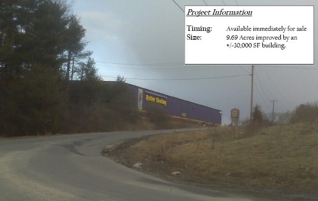
9.69 AC
2025
Fitchburg/Leominster
713100
Boston
30,630 SF
Worcester, MA
NEARBY LISTINGS FOR SALE OR LEASE
DEMOGRAPHICS near 90 Duval Rd
1 mile
3 mile
5 mile
2025 Total Population
1,183
32,069
67,089
2030 Population
1,213
32,701
68,708
Pop Growth 2025-2030
+ 2.54%
+ 1.97%
+ 2.41%
Average Age
43
41
42
2025 Total Households
359
12,582
25,835
HH Growth 2025-2030
+ 2.51%
+ 2.00%
+ 2.45%
Median Household Inc
$137,500
$82,821
$93,123
Avg Household Size
2.70
2.40
2.40
2025 Avg HH Vehicles
2.00
2.00
2.00
Median Home Value
$460,280
$402,472
$419,672
Median Year Built
1979
1959
1966
Nearby Places
Map Layers
Map Styles
 Street
 Aerial
Layers
 Traffic
 Biking
Places
Listings with unknown addresses are not visible on the map
- Restaurants
- Banks
- Shops
- Fitness
- Groceries
PUBLIC TRANSPORTATION
COMMUTER RAIL
North Leominster (Fitchburg/South Acton Line - Massachusetts Bay Transportation Authority Commuter Rail (Purple Line))
Drive
Walk
Distance
North Leominster (Fitchburg/South Acton Line - Massachusetts Bay Transportation Authority Commuter Rail (Purple Line))
5 min
2.6 mi
Shirley (Fitchburg/South Acton Line - Massachusetts Bay Transportation Authority Commuter Rail (Purple Line))
Drive
Walk
Distance
Shirley (Fitchburg/South Acton Line - Massachusetts Bay Transportation Authority Commuter Rail (Purple Line))
10 min
5.5 mi
AIRPORT
Worcester Regional
Drive
Walk
Distance
Worcester Regional
39 min
26.7 mi
Manchester Boston Regional
Drive
Walk
Distance
Manchester Boston Regional
71 min
40.8 mi
Nearby Properties
Address
Land Use
TOTAL SIZE
Lot Size
Zoning
Address
Land Use
TOTAL SIZE
Lot Size
Zoning
663,948 SF
516.30 AC
Address
Land Use
TOTAL SIZE
Lot Size
Zoning
20.19 AC
Address
Land Use
TOTAL SIZE
Lot Size
Zoning
65.15 AC
Address
Land Use
TOTAL SIZE
Lot Size
Zoning
24.35 AC
Address
Land Use
TOTAL SIZE
Lot Size
Zoning
45,066 SF
18.52 AC
Address
Land Use
TOTAL SIZE
Lot Size
Zoning
372,000 SF
30.33 AC
Address
Land Use
TOTAL SIZE
Lot Size
Zoning
552,952 SF
27.44 AC
Address
Land Use
TOTAL SIZE
Lot Size
Zoning
20.30 AC
Address
Land Use
TOTAL SIZE
Lot Size
Zoning
47,173 SF
0.76 AC
Address
Land Use
TOTAL SIZE
Lot Size
Zoning
77,758 SF
7.78 AC
Address
Land Use
TOTAL SIZE
Lot Size
Zoning
9.30 AC
Address
Land Use
TOTAL SIZE
Lot Size
Zoning
68,822 SF
9.83 AC
Address
Land Use
TOTAL SIZE
Lot Size
Zoning
171,063 SF
14.62 AC
Address
Land Use
TOTAL SIZE
Lot Size
Zoning
51,492 SF
9.34 AC
Address
Land Use
TOTAL SIZE
Lot Size
Zoning
56.75 AC
Address
Land Use
TOTAL SIZE
Lot Size
Zoning
11.14 AC
Address
Land Use
TOTAL SIZE
Lot Size
Zoning
Address
Land Use
TOTAL SIZE
Lot Size
Zoning
125,461 SF
11.27 AC
Address
Land Use
TOTAL SIZE
Lot Size
Zoning
66.70 AC
Address
Land Use
TOTAL SIZE
Lot Size
Zoning
274,272 SF
50 AC
Address
Land Use
TOTAL SIZE
Lot Size
Zoning
102,628 SF
10.50 AC
Address
Land Use
TOTAL SIZE
Lot Size
Zoning
Address
Land Use
TOTAL SIZE
Lot Size
Zoning
118,587 SF
22.30 AC
Address
Land Use
TOTAL SIZE
Lot Size
Zoning
81,594 SF
1.59 AC
Address
Land Use
TOTAL SIZE
Lot Size
Zoning
36,386 SF
2.77 AC
Address
Land Use
TOTAL SIZE
Lot Size
Zoning
4.71 AC
Address
Land Use
TOTAL SIZE
Lot Size
Zoning
12.51 AC
Address
Land Use
TOTAL SIZE
Lot Size
Zoning
34.23 AC
I
Address
Land Use
TOTAL SIZE
Lot Size
Zoning
4.30 AC
Address
Land Use
TOTAL SIZE
Lot Size
Zoning
52,440 SF
1 AC
The World's #1 Commercial Real Estate Marketplace
Connect with us
© 2026 CoStar Group
The information above has been obtained from sources believed reliable. While we do not doubt its accuracy we have not verified it and make no guarantee, warranty or representation about it. It is your responsibility to independently confirm its accuracy and completeness. Any projections, opinions, assumptions, or estimates used are for example only and do not represent the current or future performance of the property. The value of this transaction to you depends on tax and other factors which should be evaluated by your tax, financial, and legal advisors. You and your advisors should conduct a careful, independent investigation of the property to determine to your satisfaction the suitability of the property for your needs.