Property Record
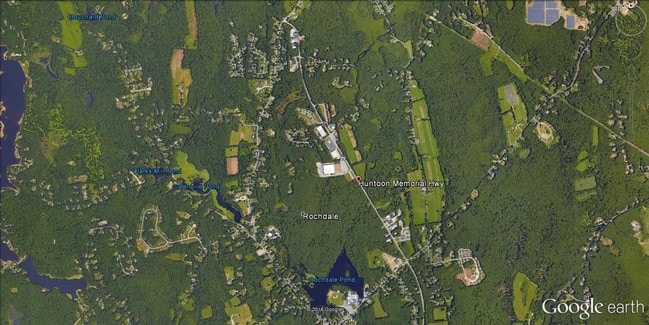
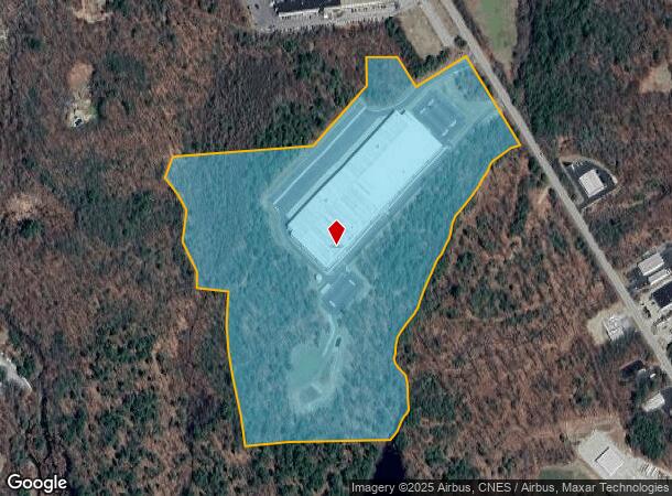
90 Huntoon Memorial Hwy, Rochdale, MA 01542
NEARBY LISTINGS FOR SALE OR LEASE
Property Detail
90 Huntoon Memorial Hwy
Warehouse
Worcester
X
Massachusetts
25027C0783F
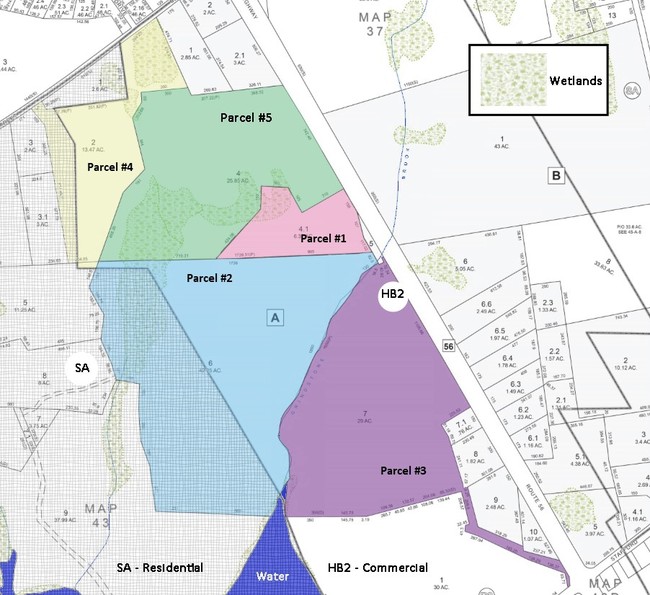
45.87 AC
2025
Outlying Worcester
2025
Boston
735200
Worcester, MA-CT
267,600 SF
LEIC-000044-A000401
DEMOGRAPHICS near 90 Huntoon Memorial Hwy
1 Mile
3 Mile
5 Mile
2024 Total Population
2,125
15,972
61,521
2029 Population
2,102
15,883
61,040
Pop Growth 2024-2029
(1.08%)
(0.56%)
(0.78%)
Average Age
43
43
42
2024 Total Households
812
6,149
24,178
HH Growth 2024-2029
(1.11%)
(0.60%)
(0.78%)
Median Household Inc
$93,446
$96,258
$80,086
Avg Household Size
2.50
2.50
2.40
2024 Avg HH Vehicles
2.00
2.00
2.00
Median Home Value
$341,079
$356,496
$334,173
Median Year Built
1968
1969
1962
Nearby Places
- Restaurants
- Banks
- Shops
- Fitness
- Groceries
PUBLIC TRANSPORTATION
COMMUTER RAIL
Worcester Union Station (Lake Shore Limited - Amtrak)
DRIVE
WALK
Distance
Worcester Union Station (Lake Shore Limited - Amtrak)
13 min
7.6 mi
Worcester (Framingham/Worcester Line - Massachusetts Bay Transportation Authority Commuter Rail (Purple Line))
DRIVE
WALK
Distance
Worcester (Framingham/Worcester Line - Massachusetts Bay Transportation Authority Commuter Rail (Purple Line))
13 min
7.8 mi
AIRPORT
Worcester Regional
DRIVE
WALK
Distance
Worcester Regional
16 min
7.8 mi
Freight Ports
Port of Boston
DRIVE
WALK
Distance
Port of Boston
70 min
51.1 mi
SALE & LEASE HISTORY
LISTING DATE
SALE/LEASE

Feb 13, 2018
For Sale
Dec 19, 2018
For Sale
Nearby Properties
Address
Land Use
TOTAL SIZE
Lot Size
Zoning
Address
Land Use
TOTAL SIZE
Lot Size
Zoning
118,112 SF
6.54 AC
Address
Land Use
TOTAL SIZE
Lot Size
Zoning
41.84 AC
Address
Land Use
TOTAL SIZE
Lot Size
Zoning
40 AC
B
Address
Land Use
TOTAL SIZE
Lot Size
Zoning
42.81 AC
Address
Land Use
TOTAL SIZE
Lot Size
Zoning
145,401 SF
23.20 AC
GB
Address
Land Use
TOTAL SIZE
Lot Size
Zoning
175,701 SF
25.85 AC
HB2
Address
Land Use
TOTAL SIZE
Lot Size
Zoning
11.30 AC
Address
Land Use
TOTAL SIZE
Lot Size
Zoning
3,552 SF
13 AC
NB
Address
Land Use
TOTAL SIZE
Lot Size
Zoning
53,096 SF
5.60 AC
Address
Land Use
TOTAL SIZE
Lot Size
Zoning
51,755 SF
5.93 AC
R1
Address
Land Use
TOTAL SIZE
Lot Size
Zoning
18,970 SF
1.91 AC
R2
Address
Land Use
TOTAL SIZE
Lot Size
Zoning
16,444 SF
0.93 AC
CB
Address
Land Use
TOTAL SIZE
Lot Size
Zoning
2.60 AC
Address
Land Use
TOTAL SIZE
Lot Size
Zoning
63,120 SF
9.10 AC
Address
Land Use
TOTAL SIZE
Lot Size
Zoning
56,415 SF
4.38 AC
B1-B
Address
Land Use
TOTAL SIZE
Lot Size
Zoning
52,128 SF
9.30 AC
Address
Land Use
TOTAL SIZE
Lot Size
Zoning
3.20 AC
Address
Land Use
TOTAL SIZE
Lot Size
Zoning
9,221 SF
15.08 AC
B
Address
Land Use
TOTAL SIZE
Lot Size
Zoning
45,172 SF
9.13 AC
Address
Land Use
TOTAL SIZE
Lot Size
Zoning
43,471 SF
1.93 AC
Address
Land Use
TOTAL SIZE
Lot Size
Zoning
1,500 SF
4.45 AC
GB
Address
Land Use
TOTAL SIZE
Lot Size
Zoning
21,770 SF
4.34 AC
Address
Land Use
TOTAL SIZE
Lot Size
Zoning
16,688 SF
6.83 AC
Address
Land Use
TOTAL SIZE
Lot Size
Zoning
23,296 SF
2.35 AC
R2
Address
Land Use
TOTAL SIZE
Lot Size
Zoning
22,818 SF
3 AC
Address
Land Use
TOTAL SIZE
Lot Size
Zoning
19 AC
R2
Address
Land Use
TOTAL SIZE
Lot Size
Zoning
48,000 SF
4.20 AC
BI-B
Address
Land Use
TOTAL SIZE
Lot Size
Zoning
9,070 SF
0.69 AC
R2
Address
Land Use
TOTAL SIZE
Lot Size
Zoning
31.58 AC
SA
The World's #1 Commercial Real Estate Marketplace
Connect with us
© 2025 CoStar Group
The information above has been obtained from sources believed reliable. While we do not doubt its accuracy we have not verified it and make no guarantee, warranty or representation about it. It is your responsibility to independently confirm its accuracy and completeness. Any projections, opinions, assumptions, or estimates used are for example only and do not represent the current or future performance of the property. The value of this transaction to you depends on tax and other factors which should be evaluated by your tax, financial, and legal advisors. You and your advisors should conduct a careful, independent investigation of the property to determine to your satisfaction the suitability of the property for your needs.