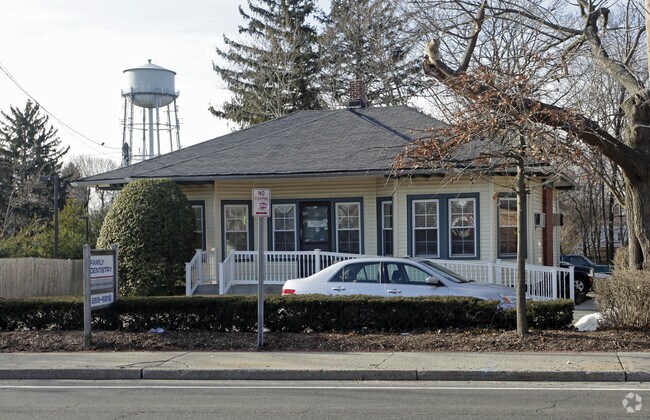
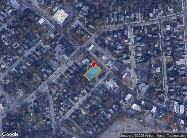
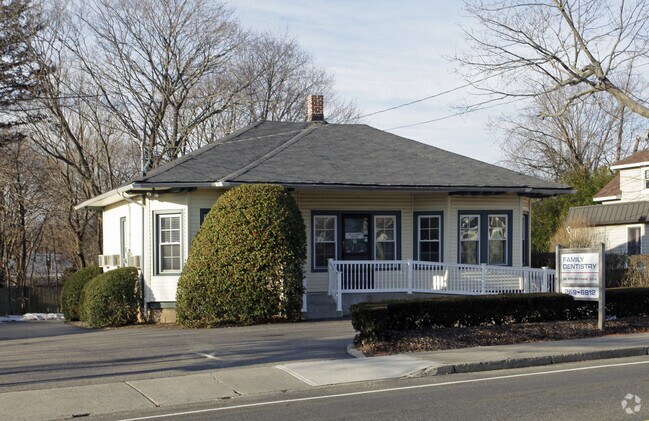
Property Record
90 Main St, Kings Park, NY 11754
NEARBY LISTINGS FOR SALE OR LEASE
Property Detail
90 Main St
Nassau County-Suffolk County, NY
12-463351 TC-63 *338 PT L21&PL 22 LOTS OC AT K P CARLSON
0800-014-00-03-00-052-000
Suffolk
Officebuilding
New York
X
52
36103C0344H
1.19 AC
2024
Western Suffolk
2024
Long Island (New York)
134702
DEMOGRAPHICS near 90 Main St
1 Mile
3 Mile
5 Mile
2024 Total Population
7,939
52,812
129,083
2029 Population
7,786
52,055
127,077
Pop Growth 2024-2029
(1.93%)
(1.43%)
(1.55%)
Average Age
45
43
43
2024 Total Households
3,046
17,581
43,757
HH Growth 2024-2029
(2.36%)
(1.83%)
(1.89%)
Median Household Inc
$101,536
$153,769
$147,632
Avg Household Size
2.50
2.90
2.80
2024 Avg HH Vehicles
2.00
2.00
2.00
Median Home Value
$514,745
$665,666
$663,921
Median Year Built
1965
1965
1963
Nearby Places
- Restaurants
- Banks
- Shops
- Fitness
- Groceries
PUBLIC TRANSPORTATION
TRANSIT/SUBWAY
Kings Park Station (Port Jefferson Branch - Long Island Rail Road)
DRIVE
WALK
Distance
Kings Park Station (Port Jefferson Branch - Long Island Rail Road)
1 min
5 min
0.3 mi
COMMUTER RAIL
Kings Park Station (Port Jefferson Branch - Long Island Rail Road)
DRIVE
WALK
Distance
Kings Park Station (Port Jefferson Branch - Long Island Rail Road)
1 min
7 min
0.4 mi
Northport Station (Port Jefferson Branch - Long Island Rail Road)
DRIVE
WALK
Distance
Northport Station (Port Jefferson Branch - Long Island Rail Road)
8 min
4.2 mi
AIRPORT
Long Island MacArthur
DRIVE
WALK
Distance
Long Island MacArthur
25 min
14.9 mi
John F Kennedy International
DRIVE
WALK
Distance
John F Kennedy International
55 min
43.0 mi
Freight Ports
NY - Red Hook Container Terminal
DRIVE
WALK
Distance
NY - Red Hook Container Terminal
70 min
49.3 mi
Nearby Properties
Address
Land Use
TOTAL SIZE
Lot Size
Zoning
Address
Land Use
TOTAL SIZE
Lot Size
Zoning
853.98 AC
Address
Land Use
TOTAL SIZE
Lot Size
Zoning
3,060 SF
0.10 AC
VILLA
Address
Land Use
TOTAL SIZE
Lot Size
Zoning
26.60 AC
Address
Land Use
TOTAL SIZE
Lot Size
Zoning
5,792 SF
0.36 AC
VILLA
Address
Land Use
TOTAL SIZE
Lot Size
Zoning
9,000 SF
0.18 AC
VILLA
Address
Land Use
TOTAL SIZE
Lot Size
Zoning
300 AC
R80
Address
Land Use
TOTAL SIZE
Lot Size
Zoning
1,648 SF
0.02 AC
VILLA
Address
Land Use
TOTAL SIZE
Lot Size
Zoning
14.50 AC
Address
Land Use
TOTAL SIZE
Lot Size
Zoning
368.36 AC
Address
Land Use
TOTAL SIZE
Lot Size
Zoning
159.25 AC
Address
Land Use
TOTAL SIZE
Lot Size
Zoning
0.23 AC
R10
Address
Land Use
TOTAL SIZE
Lot Size
Zoning
251.38 AC
Address
Land Use
TOTAL SIZE
Lot Size
Zoning
Address
Land Use
TOTAL SIZE
Lot Size
Zoning
Address
Land Use
TOTAL SIZE
Lot Size
Zoning
Address
Land Use
TOTAL SIZE
Lot Size
Zoning
18.82 AC
Address
Land Use
TOTAL SIZE
Lot Size
Zoning
6.41 AC
Address
Land Use
TOTAL SIZE
Lot Size
Zoning
267.48 AC
Address
Land Use
TOTAL SIZE
Lot Size
Zoning
6.75 AC
Address
Land Use
TOTAL SIZE
Lot Size
Zoning
0.01 AC
B1
Address
Land Use
TOTAL SIZE
Lot Size
Zoning
23.95 AC
Address
Land Use
TOTAL SIZE
Lot Size
Zoning
1,295 SF
12.40 AC
Address
Land Use
TOTAL SIZE
Lot Size
Zoning
229.06 AC
Address
Land Use
TOTAL SIZE
Lot Size
Zoning
0.52 AC
Address
Land Use
TOTAL SIZE
Lot Size
Zoning
9.97 AC
Address
Land Use
TOTAL SIZE
Lot Size
Zoning
Address
Land Use
TOTAL SIZE
Lot Size
Zoning
12.90 AC
Address
Land Use
TOTAL SIZE
Lot Size
Zoning
25.80 AC
Address
Land Use
TOTAL SIZE
Lot Size
Zoning
69.15 AC
Address
Land Use
TOTAL SIZE
Lot Size
Zoning
16.77 AC
The World's #1 Commercial Real Estate Marketplace
Connect with us
© 2025 CoStar Group
The information above has been obtained from sources believed reliable. While we do not doubt its accuracy we have not verified it and make no guarantee, warranty or representation about it. It is your responsibility to independently confirm its accuracy and completeness. Any projections, opinions, assumptions, or estimates used are for example only and do not represent the current or future performance of the property. The value of this transaction to you depends on tax and other factors which should be evaluated by your tax, financial, and legal advisors. You and your advisors should conduct a careful, independent investigation of the property to determine to your satisfaction the suitability of the property for your needs.