Property Record
90 Main St, Topsham, ME 04086


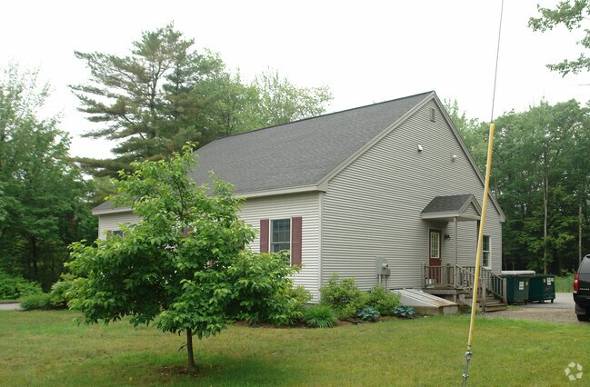
Property Detail
90 Main St
TOPM-000004-000000-000034U
SAGADAHOC
Officebuilding
Maine
NO
34
B and X Area of moderate flood hazard, usually the area between the limits of the 100-year and 500-year floods.
0.96 AC
2025
Sagadahoc County
2025
Portland/South Portland
970302
Portland-South Portland, ME
1,600 SF
NEARBY LISTINGS FOR SALE OR LEASE
DEMOGRAPHICS near 90 Main St
1 mile
3 mile
5 mile
2025 Total Population
3,801
22,459
33,064
2030 Population
3,837
23,202
34,105
Pop Growth 2025-2030
+ 0.95%
+ 3.31%
+ 3.15%
Average Age
48
43
43
2025 Total Households
1,788
9,441
13,972
HH Growth 2025-2030
+ 1.12%
+ 3.25%
+ 3.18%
Median Household Inc
$81,762
$82,699
$80,554
Avg Household Size
2.00
2.10
2.10
2025 Avg HH Vehicles
2.00
2.00
2.00
Median Home Value
$342,198
$383,999
$376,691
Median Year Built
1976
1977
1982
Nearby Places
Map Layers
Map Styles
 Street
 Aerial
Layers
 Traffic
 Biking
Places
Listings with unknown addresses are not visible on the map
- Restaurants
- Banks
- Shops
- Fitness
- Groceries
PUBLIC TRANSPORTATION
COMMUTER RAIL
Drive
Walk
Distance
3 min
1.6 mi
AIRPORT
Portland International Jetport
Drive
Walk
Distance
Portland International Jetport
41 min
30.4 mi
Nearby Properties
Address
Land Use
TOTAL SIZE
Lot Size
Zoning
Address
Land Use
TOTAL SIZE
Lot Size
Zoning
21,788 SF
34.10 AC
GC1
Address
Land Use
TOTAL SIZE
Lot Size
Zoning
11.05 AC
GM7
Address
Land Use
TOTAL SIZE
Lot Size
Zoning
616.11 AC
NO
Address
Land Use
TOTAL SIZE
Lot Size
Zoning
Address
Land Use
TOTAL SIZE
Lot Size
Zoning
17,228 SF
67.60 AC
GC5
Address
Land Use
TOTAL SIZE
Lot Size
Zoning
111,099 SF
10.40 AC
GR8
Address
Land Use
TOTAL SIZE
Lot Size
Zoning
413,793 SF
4.94 AC
GM6
Address
Land Use
TOTAL SIZE
Lot Size
Zoning
5.77 AC
Address
Land Use
TOTAL SIZE
Lot Size
Zoning
158,044 SF
29.13 AC
GM4
Address
Land Use
TOTAL SIZE
Lot Size
Zoning
96,823 SF
13 AC
GR9
Address
Land Use
TOTAL SIZE
Lot Size
Zoning
199,222 SF
46.56 AC
NO
Address
Land Use
TOTAL SIZE
Lot Size
Zoning
5,238 SF
3.99 AC
GC1
Address
Land Use
TOTAL SIZE
Lot Size
Zoning
51,162 SF
29.25 AC
GR9
Address
Land Use
TOTAL SIZE
Lot Size
Zoning
55 AC
GR4
Address
Land Use
TOTAL SIZE
Lot Size
Zoning
30.78 AC
NO
Address
Land Use
TOTAL SIZE
Lot Size
Zoning
49,175 SF
6.70 AC
GM7
Address
Land Use
TOTAL SIZE
Lot Size
Zoning
74,778 SF
23.51 AC
GM8
Address
Land Use
TOTAL SIZE
Lot Size
Zoning
124,514 SF
10.76 AC
NO
Address
Land Use
TOTAL SIZE
Lot Size
Zoning
16,090 SF
3.77 AC
GC2
Address
Land Use
TOTAL SIZE
Lot Size
Zoning
73,164 SF
5.94 AC
GI
Address
Land Use
TOTAL SIZE
Lot Size
Zoning
44,245 SF
2.81 AC
GC3
Address
Land Use
TOTAL SIZE
Lot Size
Zoning
168,560 SF
11.61 AC
GA
Address
Land Use
TOTAL SIZE
Lot Size
Zoning
25,262 SF
1.03 AC
GC1
Address
Land Use
TOTAL SIZE
Lot Size
Zoning
29,788 SF
0.93 AC
GC1
Address
Land Use
TOTAL SIZE
Lot Size
Zoning
101,903 SF
7.25 AC
NO
Address
Land Use
TOTAL SIZE
Lot Size
Zoning
94,968 SF
16.88 AC
NO
Address
Land Use
TOTAL SIZE
Lot Size
Zoning
111,786 SF
4.20 AC
GM3
Address
Land Use
TOTAL SIZE
Lot Size
Zoning
78,120 SF
28.71 AC
NO
Address
Land Use
TOTAL SIZE
Lot Size
Zoning
27,134 SF
2.45 AC
GM5
Address
Land Use
TOTAL SIZE
Lot Size
Zoning
59,854 SF
10.35 AC
GM8
The World's #1 Commercial Real Estate Marketplace
Connect with us
© 2026 CoStar Group
The information above has been obtained from sources believed reliable. While we do not doubt its accuracy we have not verified it and make no guarantee, warranty or representation about it. It is your responsibility to independently confirm its accuracy and completeness. Any projections, opinions, assumptions, or estimates used are for example only and do not represent the current or future performance of the property. The value of this transaction to you depends on tax and other factors which should be evaluated by your tax, financial, and legal advisors. You and your advisors should conduct a careful, independent investigation of the property to determine to your satisfaction the suitability of the property for your needs.