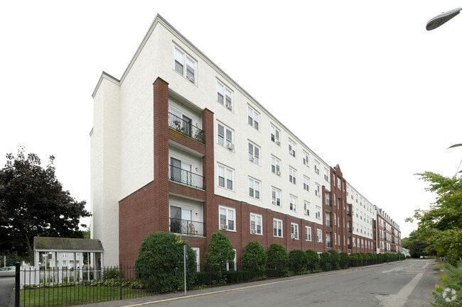
Property Record
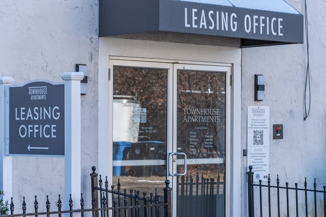
90 Myrtle Ave, Whitman, MA 02382
NEARBY LISTINGS FOR SALE OR LEASE
-
-
View all Whitman listings for sale on LoopNet.com
Property Detail
90 Myrtle Ave
WHIT-000003-000037-000006
Plymouth
Apartment
Massachusetts
X
6
25023C0179J
1.17 AC
2025
South Plymouth County
2025
Boston
521102
Boston-Cambridge-Newton, MA-NH
60,840 SF
DEMOGRAPHICS near 90 Myrtle Ave
1 mile
3 mile
5 mile
2024 Total Population
8,900
44,962
157,075
2029 Population
8,807
44,964
155,954
Pop Growth 2024-2029
(1.04%)
0.00%
(0.71%)
Average Age
40
41
40
2024 Total Households
3,391
16,112
55,230
HH Growth 2024-2029
(1.18%)
(0.14%)
(0.76%)
Median Household Inc
$94,261
$100,474
$89,288
Avg Household Size
2.60
2.70
2.70
2024 Avg HH Vehicles
2.00
2.00
2.00
Median Home Value
$412,585
$425,446
$411,217
Median Year Built
1949
1966
1959
Nearby Places
Map Layers
Map Styles
 Street
 Aerial
Transit
 Traffic
 Biking
Places
Listings with unknown addresses are not visible on the map
- Restaurants
- Banks
- Shops
- Fitness
- Groceries
PUBLIC TRANSPORTATION
COMMUTER RAIL
Whitman (Kingston/Plymouth Line - Massachusetts Bay Transportation Authority Commuter Rail (Purple Line))
Drive
Walk
Distance
Whitman (Kingston/Plymouth Line - Massachusetts Bay Transportation Authority Commuter Rail (Purple Line))
3 min
1.2 mi
Abington (Kingston/Plymouth Line - Massachusetts Bay Transportation Authority Commuter Rail (Purple Line))
Drive
Walk
Distance
Abington (Kingston/Plymouth Line - Massachusetts Bay Transportation Authority Commuter Rail (Purple Line))
5 min
2.3 mi
AIRPORT
General Edward Lawrence Logan International
Drive
Walk
Distance
General Edward Lawrence Logan International
40 min
25.5 mi
Freight Ports
Port of Boston
Drive
Walk
Distance
Port of Boston
37 min
23.3 mi
Nearby Properties
Address
Land Use
TOTAL SIZE
Lot Size
Zoning
Address
Land Use
TOTAL SIZE
Lot Size
Zoning
95.27 AC
R1C
Address
Land Use
TOTAL SIZE
Lot Size
Zoning
780 SF
10.81 AC
C5
Address
Land Use
TOTAL SIZE
Lot Size
Zoning
69.93 AC
100
Address
Land Use
TOTAL SIZE
Lot Size
Zoning
449,704 SF
3.56 AC
C2
Address
Land Use
TOTAL SIZE
Lot Size
Zoning
412,500 SF
48.94 AC
100
Address
Land Use
TOTAL SIZE
Lot Size
Zoning
733 SF
16.41 AC
R1C
Address
Land Use
TOTAL SIZE
Lot Size
Zoning
36.20 AC
Address
Land Use
TOTAL SIZE
Lot Size
Zoning
920 SF
13.48 AC
R1C
Address
Land Use
TOTAL SIZE
Lot Size
Zoning
35.10 AC
Address
Land Use
TOTAL SIZE
Lot Size
Zoning
1,172 SF
32.67 AC
R1C
Address
Land Use
TOTAL SIZE
Lot Size
Zoning
16.12 AC
RESIDE
Address
Land Use
TOTAL SIZE
Lot Size
Zoning
22.54 AC
C2
Address
Land Use
TOTAL SIZE
Lot Size
Zoning
48,997 SF
5.68 AC
R3
Address
Land Use
TOTAL SIZE
Lot Size
Zoning
69,184 SF
7.90 AC
100
Address
Land Use
TOTAL SIZE
Lot Size
Zoning
53,538 SF
2.95 AC
C5
Address
Land Use
TOTAL SIZE
Lot Size
Zoning
2.24 AC
GB
Address
Land Use
TOTAL SIZE
Lot Size
Zoning
9.30 AC
BUSINE
Address
Land Use
TOTAL SIZE
Lot Size
Zoning
55.90 AC
Address
Land Use
TOTAL SIZE
Lot Size
Zoning
106,907 SF
26.42 AC
A1
Address
Land Use
TOTAL SIZE
Lot Size
Zoning
63,760 SF
9.67 AC
Address
Land Use
TOTAL SIZE
Lot Size
Zoning
43.94 AC
100
Address
Land Use
TOTAL SIZE
Lot Size
Zoning
127,644 SF
15.76 AC
Address
Land Use
TOTAL SIZE
Lot Size
Zoning
78,120 SF
1.61 AC
GB
Address
Land Use
TOTAL SIZE
Lot Size
Zoning
14.20 AC
Address
Land Use
TOTAL SIZE
Lot Size
Zoning
116,122 SF
19.57 AC
Address
Land Use
TOTAL SIZE
Lot Size
Zoning
1,824 SF
12.42 AC
R2
Address
Land Use
TOTAL SIZE
Lot Size
Zoning
118,745 SF
18.78 AC
Address
Land Use
TOTAL SIZE
Lot Size
Zoning
25.10 AC
Address
Land Use
TOTAL SIZE
Lot Size
Zoning
66,412 SF
10.36 AC
HB
The World's #1 Commercial Real Estate Marketplace
Connect with us
© 2026 CoStar Group
The information above has been obtained from sources believed reliable. While we do not doubt its accuracy we have not verified it and make no guarantee, warranty or representation about it. It is your responsibility to independently confirm its accuracy and completeness. Any projections, opinions, assumptions, or estimates used are for example only and do not represent the current or future performance of the property. The value of this transaction to you depends on tax and other factors which should be evaluated by your tax, financial, and legal advisors. You and your advisors should conduct a careful, independent investigation of the property to determine to your satisfaction the suitability of the property for your needs.