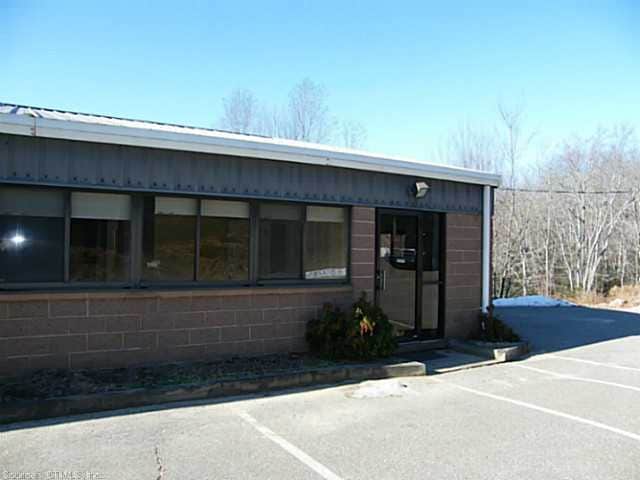
Property Record
90 Pond Meadow Rd, Ivoryton, CT 06442

NEARBY LISTINGS FOR SALE OR LEASE
-
-
View all Ivoryton listings for lease on LoopNet.com
Property Detail
90 Pond Meadow Rd
ESSE-000088-000005-000001
Middlesex
Industrialgeneral
Connecticut
AE
1
09007C0329G
3.41 AC
2025
SW Midlsx/Old Saybrk
2025
Hartford
630101
Hartford-West Hartford-East Hartford, CT
9,986 SF
DEMOGRAPHICS near 90 Pond Meadow Rd
1 Mile
3 Mile
5 Mile
2024 Total Population
1,515
10,106
34,659
2029 Population
1,509
10,043
34,949
Pop Growth 2024-2029
(0.40%)
(0.62%)
+ 0.84%
Average Age
46
47
48
2024 Total Households
603
4,100
15,141
HH Growth 2024-2029
(0.66%)
(0.71%)
+ 0.88%
Median Household Inc
$98,089
$97,807
$96,212
Avg Household Size
2.40
2.30
2.20
2024 Avg HH Vehicles
2.00
2.00
2.00
Median Home Value
$384,396
$373,326
$371,190
Median Year Built
1980
1976
1970
Nearby Places
Map Layers
Map Styles
 Street
 Aerial
- Restaurants
- Banks
- Shops
- Fitness
- Groceries
PUBLIC TRANSPORTATION
COMMUTER RAIL
DRIVE
WALK
Distance
13 min
5.0 mi
Westbrook (Shore Line East - Shore Line East)
DRIVE
WALK
Distance
Westbrook (Shore Line East - Shore Line East)
13 min
5.0 mi
AIRPORT
Tweed/New Haven
DRIVE
WALK
Distance
Tweed/New Haven
41 min
27.0 mi
SALE & LEASE HISTORY
LISTING DATE
SALE/LEASE

Mar 20, 2018
For Lease
Dec 31, 2020
For Lease
Nearby Properties
Address
Land Use
TOTAL SIZE
Lot Size
Zoning
Address
Land Use
TOTAL SIZE
Lot Size
Zoning
66.05 AC
PRD
Address
Land Use
TOTAL SIZE
Lot Size
Zoning
108.89 AC
RLC
Address
Land Use
TOTAL SIZE
Lot Size
Zoning
159,832 SF
110.10 AC
RR
Address
Land Use
TOTAL SIZE
Lot Size
Zoning
38.67 AC
R60
Address
Land Use
TOTAL SIZE
Lot Size
Zoning
39.32 AC
LI/LDR
Address
Land Use
TOTAL SIZE
Lot Size
Zoning
322.64 AC
RR/MDR
Address
Land Use
TOTAL SIZE
Lot Size
Zoning
2,100 SF
434.75 AC
R80
Address
Land Use
TOTAL SIZE
Lot Size
Zoning
189,678 SF
44.72 AC
LI
Address
Land Use
TOTAL SIZE
Lot Size
Zoning
14.98 AC
VR
Address
Land Use
TOTAL SIZE
Lot Size
Zoning
85,800 SF
11.56 AC
LI/RR
Address
Land Use
TOTAL SIZE
Lot Size
Zoning
18,494 SF
10.40 AC
RU
Address
Land Use
TOTAL SIZE
Lot Size
Zoning
37,246 SF
25.83 AC
LDR
Address
Land Use
TOTAL SIZE
Lot Size
Zoning
317.02 AC
RR
Address
Land Use
TOTAL SIZE
Lot Size
Zoning
849 AC
C
Address
Land Use
TOTAL SIZE
Lot Size
Zoning
3.87 AC
LI
Address
Land Use
TOTAL SIZE
Lot Size
Zoning
27,277 SF
C
Address
Land Use
TOTAL SIZE
Lot Size
Zoning
8.10 AC
C
Address
Land Use
TOTAL SIZE
Lot Size
Zoning
15,730 SF
2.19 AC
B
Address
Land Use
TOTAL SIZE
Lot Size
Zoning
25,248 SF
1.65 AC
B
Address
Land Use
TOTAL SIZE
Lot Size
Zoning
50.35 AC
CIP
Address
Land Use
TOTAL SIZE
Lot Size
Zoning
5.18 AC
LI
Address
Land Use
TOTAL SIZE
Lot Size
Zoning
128,547 SF
8.65 AC
LI
Address
Land Use
TOTAL SIZE
Lot Size
Zoning
4 AC
LI
Address
Land Use
TOTAL SIZE
Lot Size
Zoning
2 AC
C
Address
Land Use
TOTAL SIZE
Lot Size
Zoning
5.45 AC
LI
Address
Land Use
TOTAL SIZE
Lot Size
Zoning
49,106 SF
11 AC
LI
Address
Land Use
TOTAL SIZE
Lot Size
Zoning
3.87 AC
C
Address
Land Use
TOTAL SIZE
Lot Size
Zoning
54,940 SF
13.94 AC
LI
Address
Land Use
TOTAL SIZE
Lot Size
Zoning
42,500 SF
LI
Address
Land Use
TOTAL SIZE
Lot Size
Zoning
13.31 AC
RU
The World's #1 Commercial Real Estate Marketplace
Connect with us
© 2025 CoStar Group
The information above has been obtained from sources believed reliable. While we do not doubt its accuracy we have not verified it and make no guarantee, warranty or representation about it. It is your responsibility to independently confirm its accuracy and completeness. Any projections, opinions, assumptions, or estimates used are for example only and do not represent the current or future performance of the property. The value of this transaction to you depends on tax and other factors which should be evaluated by your tax, financial, and legal advisors. You and your advisors should conduct a careful, independent investigation of the property to determine to your satisfaction the suitability of the property for your needs.