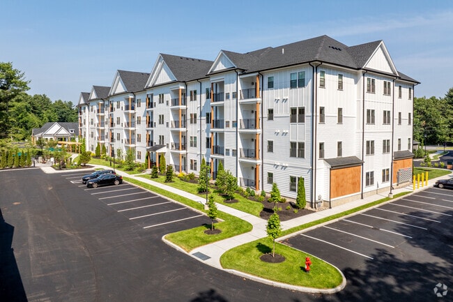
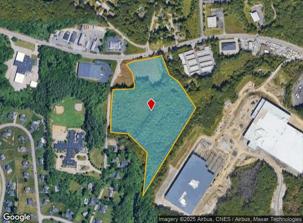
Property Record
100 Shrewsbury St, Boylston, MA 01505
Current Lease Availabilities
NEARBY LISTINGS FOR SALE OR LEASE
Property Detail
100 Shrewsbury St
BOYL-000012-000025-000002
Worcester
Apartment
Massachusetts
X
2
25027C0628G
18.14 AC
2025
Northeast Worcester County
2025
Boston
718100
Worcester, MA-CT
72,596 SF
DEMOGRAPHICS near 100 Shrewsbury St
1 Mile
3 Mile
5 Mile
2024 Total Population
1,922
30,055
111,687
2029 Population
2,014
30,928
114,378
Pop Growth 2024-2029
+ 4.79%
+ 2.90%
+ 2.41%
Average Age
44
41
41
2024 Total Households
742
11,115
43,768
HH Growth 2024-2029
+ 4.85%
+ 2.98%
+ 2.47%
Median Household Inc
$124,689
$110,313
$104,435
Avg Household Size
2.60
2.60
2.50
2024 Avg HH Vehicles
2.00
2.00
2.00
Median Home Value
$684,673
$496,754
$482,272
Median Year Built
1982
1967
1965
Nearby Places
Map Layers
Map Styles
 Street
 Aerial
- Restaurants
- Banks
- Shops
- Fitness
- Groceries
PUBLIC TRANSPORTATION
COMMUTER RAIL
Worcester Union Station (Lake Shore Limited - Amtrak)
DRIVE
WALK
Distance
Worcester Union Station (Lake Shore Limited - Amtrak)
12 min
8.5 mi
Worcester (Framingham/Worcester Line - Massachusetts Bay Transportation Authority Commuter Rail (Purple Line))
DRIVE
WALK
Distance
Worcester (Framingham/Worcester Line - Massachusetts Bay Transportation Authority Commuter Rail (Purple Line))
13 min
8.5 mi
AIRPORT
Worcester Regional
DRIVE
WALK
Distance
Worcester Regional
22 min
13.0 mi
Freight Ports
Port of Boston
DRIVE
WALK
Distance
Port of Boston
62 min
46.9 mi
Nearby Properties
Address
Land Use
TOTAL SIZE
Lot Size
Zoning
Address
Land Use
TOTAL SIZE
Lot Size
Zoning
362,937 SF
91.58 AC
Address
Land Use
TOTAL SIZE
Lot Size
Zoning
295,000 SF
194.17 AC
RUR B
Address
Land Use
TOTAL SIZE
Lot Size
Zoning
30.93 AC
RG-5
Address
Land Use
TOTAL SIZE
Lot Size
Zoning
15.37 AC
RS-7
Address
Land Use
TOTAL SIZE
Lot Size
Zoning
13.95 AC
RG-5
Address
Land Use
TOTAL SIZE
Lot Size
Zoning
217,500 SF
51.71 AC
LIM CO
Address
Land Use
TOTAL SIZE
Lot Size
Zoning
1,839.82 AC
Address
Land Use
TOTAL SIZE
Lot Size
Zoning
373,550 SF
29.05 AC
Address
Land Use
TOTAL SIZE
Lot Size
Zoning
6.70 AC
RG-5
Address
Land Use
TOTAL SIZE
Lot Size
Zoning
24,243 SF
168.59 AC
Address
Land Use
TOTAL SIZE
Lot Size
Zoning
423,883 SF
59.55 AC
Address
Land Use
TOTAL SIZE
Lot Size
Zoning
40,733 SF
4.93 AC
LIM CO
Address
Land Use
TOTAL SIZE
Lot Size
Zoning
299,228 SF
32.39 AC
Address
Land Use
TOTAL SIZE
Lot Size
Zoning
5.67 AC
RG-5
Address
Land Use
TOTAL SIZE
Lot Size
Zoning
6.09 AC
RG-5
Address
Land Use
TOTAL SIZE
Lot Size
Zoning
83,148 SF
2.63 AC
ML-.5
Address
Land Use
TOTAL SIZE
Lot Size
Zoning
84.73 AC
RES A
Address
Land Use
TOTAL SIZE
Lot Size
Zoning
2,144 SF
8.14 AC
RG-5
Address
Land Use
TOTAL SIZE
Lot Size
Zoning
20.50 AC
LIM IN
Address
Land Use
TOTAL SIZE
Lot Size
Zoning
206,734 SF
13.49 AC
RS-7
Address
Land Use
TOTAL SIZE
Lot Size
Zoning
32,844 SF
13.30 AC
Address
Land Use
TOTAL SIZE
Lot Size
Zoning
99,584 SF
5.72 AC
RS-7
Address
Land Use
TOTAL SIZE
Lot Size
Zoning
300 SF
1,808.83 AC
Address
Land Use
TOTAL SIZE
Lot Size
Zoning
69,375 SF
3.07 AC
RG-5
Address
Land Use
TOTAL SIZE
Lot Size
Zoning
3.39 AC
RG-5
Address
Land Use
TOTAL SIZE
Lot Size
Zoning
59,839 SF
17.30 AC
Address
Land Use
TOTAL SIZE
Lot Size
Zoning
573.65 AC
Address
Land Use
TOTAL SIZE
Lot Size
Zoning
86,038 SF
26.68 AC
Address
Land Use
TOTAL SIZE
Lot Size
Zoning
5.46 AC
BL-1
The World's #1 Commercial Real Estate Marketplace
Connect with us
© 2026 CoStar Group
The information above has been obtained from sources believed reliable. While we do not doubt its accuracy we have not verified it and make no guarantee, warranty or representation about it. It is your responsibility to independently confirm its accuracy and completeness. Any projections, opinions, assumptions, or estimates used are for example only and do not represent the current or future performance of the property. The value of this transaction to you depends on tax and other factors which should be evaluated by your tax, financial, and legal advisors. You and your advisors should conduct a careful, independent investigation of the property to determine to your satisfaction the suitability of the property for your needs.