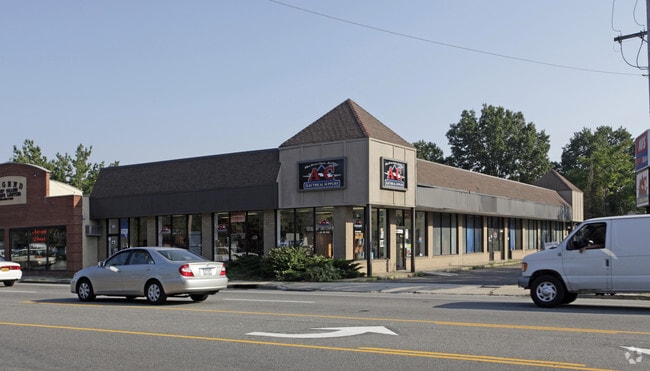
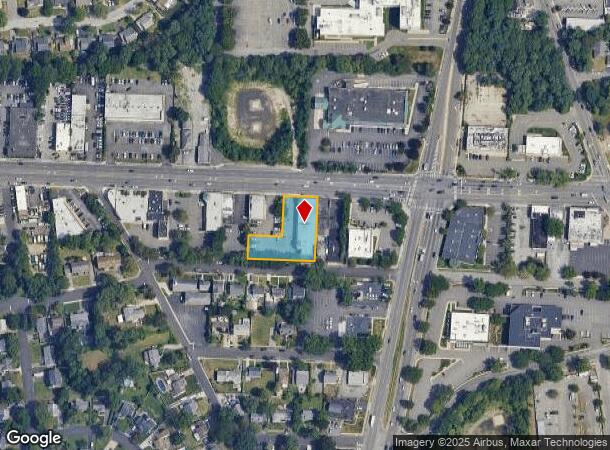
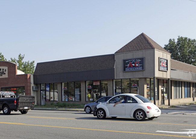
Property Record
90 W Jericho Tpke, Huntington Station, NY 11746
NEARBY LISTINGS FOR SALE OR LEASE
Property Detail
90 W Jericho Tpke
Nassau County-Suffolk County, NY
FILED LOTS 26-30 &,LOTS 5& S 70,OF LOTS 63-67
0400-195-00-04-00-019-004
Suffolk
Commercialnec
New York
X
19
36103C0610H
0.60 AC
2024
Western Suffolk
2024
Long Island (New York)
112001
DEMOGRAPHICS near 90 W Jericho Tpke
1 Mile
3 Mile
5 Mile
2024 Total Population
14,531
77,852
175,831
2029 Population
14,082
76,094
172,860
Pop Growth 2024-2029
(3.09%)
(2.26%)
(1.69%)
Average Age
39
42
43
2024 Total Households
4,471
25,516
59,229
HH Growth 2024-2029
(3.31%)
(2.41%)
(1.85%)
Median Household Inc
$118,129
$129,879
$147,895
Avg Household Size
3.00
2.90
2.80
2024 Avg HH Vehicles
2.00
2.00
2.00
Median Home Value
$459,923
$645,689
$728,757
Median Year Built
1956
1960
1962
Nearby Places
- Restaurants
- Banks
- Shops
- Fitness
- Groceries
PUBLIC TRANSPORTATION
COMMUTER RAIL
Huntington Station (Port Jefferson Branch - Long Island Rail Road)
DRIVE
WALK
Distance
Huntington Station (Port Jefferson Branch - Long Island Rail Road)
5 min
2.0 mi
Cold Spring Harbor Station (Port Jefferson Branch - Long Island Rail Road)
DRIVE
WALK
Distance
Cold Spring Harbor Station (Port Jefferson Branch - Long Island Rail Road)
6 min
2.8 mi
AIRPORT
Long Island MacArthur
DRIVE
WALK
Distance
Long Island MacArthur
32 min
18.5 mi
John F Kennedy International
DRIVE
WALK
Distance
John F Kennedy International
46 min
31.8 mi
Westchester County
DRIVE
WALK
Distance
Westchester County
75 min
48.6 mi
Freight Ports
NY - Red Hook Container Terminal
DRIVE
WALK
Distance
NY - Red Hook Container Terminal
56 min
36.3 mi
Nearby Properties
Address
Land Use
TOTAL SIZE
Lot Size
Zoning
Address
Land Use
TOTAL SIZE
Lot Size
Zoning
65 AC
C6
Address
Land Use
TOTAL SIZE
Lot Size
Zoning
0.06 AC
VILLA
Address
Land Use
TOTAL SIZE
Lot Size
Zoning
1.50 AC
CR80
Address
Land Use
TOTAL SIZE
Lot Size
Zoning
0.06 AC
VILLA
Address
Land Use
TOTAL SIZE
Lot Size
Zoning
0.02 AC
VILLA
Address
Land Use
TOTAL SIZE
Lot Size
Zoning
0.04 AC
VILLA
Address
Land Use
TOTAL SIZE
Lot Size
Zoning
0.05 AC
VILLA
Address
Land Use
TOTAL SIZE
Lot Size
Zoning
0.05 AC
VILLA
Address
Land Use
TOTAL SIZE
Lot Size
Zoning
0.05 AC
VILLA
Address
Land Use
TOTAL SIZE
Lot Size
Zoning
0.05 AC
VILLA
Address
Land Use
TOTAL SIZE
Lot Size
Zoning
0.03 AC
VILLA
Address
Land Use
TOTAL SIZE
Lot Size
Zoning
0.04 AC
VILLA
Address
Land Use
TOTAL SIZE
Lot Size
Zoning
0.04 AC
VILLA
Address
Land Use
TOTAL SIZE
Lot Size
Zoning
0.03 AC
VILLA
Address
Land Use
TOTAL SIZE
Lot Size
Zoning
0.02 AC
VILLA
Address
Land Use
TOTAL SIZE
Lot Size
Zoning
0.04 AC
VILLA
Address
Land Use
TOTAL SIZE
Lot Size
Zoning
0.04 AC
VILLA
Address
Land Use
TOTAL SIZE
Lot Size
Zoning
0.04 AC
VILLA
Address
Land Use
TOTAL SIZE
Lot Size
Zoning
0.04 AC
VILLA
Address
Land Use
TOTAL SIZE
Lot Size
Zoning
0.04 AC
VILLA
Address
Land Use
TOTAL SIZE
Lot Size
Zoning
0.23 AC
VILLA
Address
Land Use
TOTAL SIZE
Lot Size
Zoning
0.03 AC
VILLA
Address
Land Use
TOTAL SIZE
Lot Size
Zoning
0.03 AC
VILLA
Address
Land Use
TOTAL SIZE
Lot Size
Zoning
0.03 AC
VILLA
Address
Land Use
TOTAL SIZE
Lot Size
Zoning
32.67 AC
R80
Address
Land Use
TOTAL SIZE
Lot Size
Zoning
36 AC
R20
Address
Land Use
TOTAL SIZE
Lot Size
Zoning
0.03 AC
VILLA
Address
Land Use
TOTAL SIZE
Lot Size
Zoning
0.03 AC
VILLA
Address
Land Use
TOTAL SIZE
Lot Size
Zoning
Address
Land Use
TOTAL SIZE
Lot Size
Zoning
0.02 AC
VILLA
The World's #1 Commercial Real Estate Marketplace
Connect with us
© 2025 CoStar Group
The information above has been obtained from sources believed reliable. While we do not doubt its accuracy we have not verified it and make no guarantee, warranty or representation about it. It is your responsibility to independently confirm its accuracy and completeness. Any projections, opinions, assumptions, or estimates used are for example only and do not represent the current or future performance of the property. The value of this transaction to you depends on tax and other factors which should be evaluated by your tax, financial, and legal advisors. You and your advisors should conduct a careful, independent investigation of the property to determine to your satisfaction the suitability of the property for your needs.