Property Record
90 W Thornton St, Akron, OH 44311


Save to a Folder
{{folder.Name}}
{{folder.ListingIds.length}} Properties
{{folder.ListingIds.length}} Property
Create a New Folder
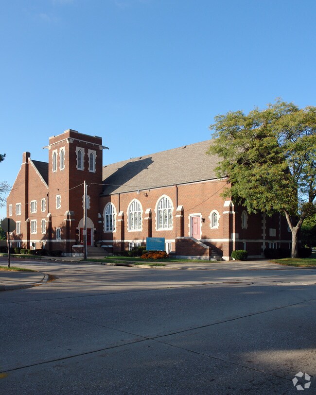
Property Detail
90 W Thornton St
Akron, OH
COBURN LOT 238 ALL LESS N PT THORNTON ST 63.17FT; AUD#11049 ;SEE 68-61819 FOR TAXABLE
68-33967
Summit
Religious
Ohio
B and X Area of moderate flood hazard, usually the area between the limits of the 100-year and 500-year floods.
238
2025
0.21 AC
2026
Akron
501900
Cleveland
15,180 SF
NEARBY LISTINGS FOR SALE OR LEASE
DEMOGRAPHICS near 90 W Thornton St
1 mile
3 mile
5 mile
2025 Total Population
12,252
109,604
212,536
2030 Population
12,426
110,605
213,092
Pop Growth 2025-2030
+ 1.42%
+ 0.91%
+ 0.26%
Average Age
34
38
40
2025 Total Households
4,893
46,361
91,907
HH Growth 2025-2030
+ 1.35%
+ 0.88%
+ 0.22%
Median Household Inc
$26,335
$39,894
$49,082
Avg Household Size
2.10
2.20
2.20
2025 Avg HH Vehicles
1.00
1.00
2.00
Median Home Value
$86,110
$95,144
$135,333
Median Year Built
1965
1949
1953
Nearby Places
Map Layers
Map Styles
 Street
 Aerial
Layers
 Traffic
 Biking
Places
Listings with unknown addresses are not visible on the map
- Restaurants
- Banks
- Shops
- Fitness
- Groceries
PUBLIC TRANSPORTATION
COMMUTER RAIL
Drive
Walk
Distance
6 min
2.2 mi
Drive
Walk
Distance
12 min
5.4 mi
AIRPORT
Akron-Canton Regional
Drive
Walk
Distance
Akron-Canton Regional
19 min
13.7 mi
Cleveland-Hopkins International
Drive
Walk
Distance
Cleveland-Hopkins International
53 min
39.4 mi
Nearby Properties
Address
Land Use
TOTAL SIZE
Lot Size
Zoning
Address
Land Use
TOTAL SIZE
Lot Size
Zoning
1,811,279 SF
38.71 AC
Address
Land Use
TOTAL SIZE
Lot Size
Zoning
1,004,220 SF
3.84 AC
Address
Land Use
TOTAL SIZE
Lot Size
Zoning
148,212 SF
2.84 AC
Address
Land Use
TOTAL SIZE
Lot Size
Zoning
184.01 AC
Address
Land Use
TOTAL SIZE
Lot Size
Zoning
348,519 SF
7.45 AC
Address
Land Use
TOTAL SIZE
Lot Size
Zoning
472,380 SF
4.55 AC
Address
Land Use
TOTAL SIZE
Lot Size
Zoning
225,751 SF
0.16 AC
Address
Land Use
TOTAL SIZE
Lot Size
Zoning
404,207 SF
2.19 AC
Address
Land Use
TOTAL SIZE
Lot Size
Zoning
203,458 SF
10.41 AC
Address
Land Use
TOTAL SIZE
Lot Size
Zoning
9.19 AC
Address
Land Use
TOTAL SIZE
Lot Size
Zoning
92,152 SF
1.69 AC
Address
Land Use
TOTAL SIZE
Lot Size
Zoning
121,738 SF
1.60 AC
Address
Land Use
TOTAL SIZE
Lot Size
Zoning
246,312 SF
17.50 AC
Address
Land Use
TOTAL SIZE
Lot Size
Zoning
56.06 AC
Address
Land Use
TOTAL SIZE
Lot Size
Zoning
23.26 AC
Address
Land Use
TOTAL SIZE
Lot Size
Zoning
3.15 AC
Address
Land Use
TOTAL SIZE
Lot Size
Zoning
257,958 SF
4.64 AC
Address
Land Use
TOTAL SIZE
Lot Size
Zoning
186,867 SF
1.48 AC
Address
Land Use
TOTAL SIZE
Lot Size
Zoning
10.78 AC
Address
Land Use
TOTAL SIZE
Lot Size
Zoning
423,125 SF
5.57 AC
Address
Land Use
TOTAL SIZE
Lot Size
Zoning
0.41 AC
Address
Land Use
TOTAL SIZE
Lot Size
Zoning
183,227 SF
4.29 AC
Address
Land Use
TOTAL SIZE
Lot Size
Zoning
347,139 SF
9.65 AC
Address
Land Use
TOTAL SIZE
Lot Size
Zoning
51,702 SF
0.36 AC
Address
Land Use
TOTAL SIZE
Lot Size
Zoning
3.16 AC
Address
Land Use
TOTAL SIZE
Lot Size
Zoning
66,302 SF
10.87 AC
Address
Land Use
TOTAL SIZE
Lot Size
Zoning
52,803 SF
1.33 AC
Address
Land Use
TOTAL SIZE
Lot Size
Zoning
275,025 SF
0.98 AC
Address
Land Use
TOTAL SIZE
Lot Size
Zoning
232,791 SF
8.16 AC
Address
Land Use
TOTAL SIZE
Lot Size
Zoning
210,474 SF
1.87 AC
The World's #1 Commercial Real Estate Marketplace
Connect with us
© 2026 CoStar Group
The information above has been obtained from sources believed reliable. While we do not doubt its accuracy we have not verified it and make no guarantee, warranty or representation about it. It is your responsibility to independently confirm its accuracy and completeness. Any projections, opinions, assumptions, or estimates used are for example only and do not represent the current or future performance of the property. The value of this transaction to you depends on tax and other factors which should be evaluated by your tax, financial, and legal advisors. You and your advisors should conduct a careful, independent investigation of the property to determine to your satisfaction the suitability of the property for your needs.