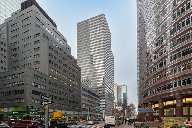
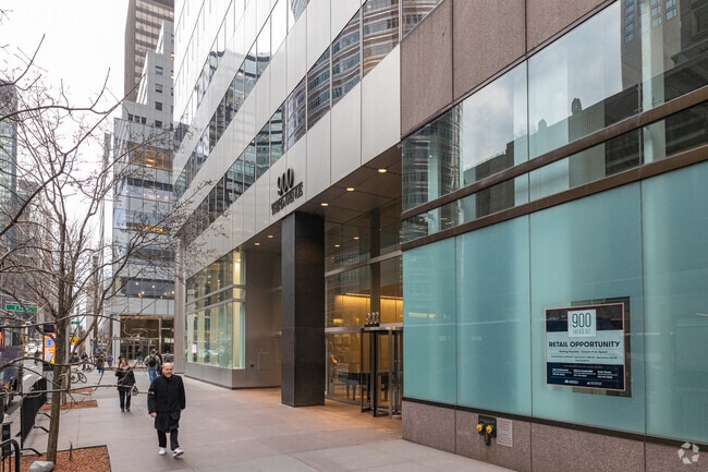
Property Record
900 3Rd Ave, New York, NY 10022


Save to a Folder
{{folder.Name}}
{{folder.ListingIds.length}} Properties
{{folder.ListingIds.length}} Property
Create a New Folder
Current Lease Availabilities
Property Detail
900 3Rd Ave
1309-0032
New York
Officebuilding
New York
C6-6
32
B and X Area of moderate flood hazard, usually the area between the limits of the 100-year and 500-year floods.
0.39 AC
2025
Plaza District
2026
New York City
010000
New York-Jersey City-White Plains, NY-NJ
516,710 SF
NEARBY LISTINGS FOR SALE OR LEASE
DEMOGRAPHICS near 900 3Rd Ave
1 mile
3 mile
5 mile
2025 Total Population
177,031
1,405,695
3,081,560
2030 Population
187,452
1,468,048
3,189,492
Pop Growth 2025-2030
+ 5.89%
+ 4.44%
+ 3.50%
Average Age
44
41
40
2025 Total Households
99,734
703,014
1,361,255
HH Growth 2025-2030
+ 6.37%
+ 4.76%
+ 3.90%
Median Household Inc
$158,912
$122,144
$101,398
Avg Household Size
1.70
1.90
2.10
2025 Avg HH Vehicles
.00
.00
.00
Median Home Value
$1,020,946
$1,014,895
$904,340
Median Year Built
1961
1957
1957
Nearby Places
Map Layers
Map Styles
 Street
 Aerial
Layers
 Traffic
 Biking
Places
Listings with unknown addresses are not visible on the map
- Restaurants
- Banks
- Shops
- Fitness
- Groceries
PUBLIC TRANSPORTATION
TRANSIT/SUBWAY
Lexington Av/53 St (8 Avenue Local - MTA New York City Transit, Queens Blvd Local/6 Av Local - MTA New York City Transit)
Drive
Walk
Distance
Lexington Av/53 St (8 Avenue Local - MTA New York City Transit, Queens Blvd Local/6 Av Local - MTA New York City Transit)
1 min
1 min
0.1 mi
Lexington Avenue-53 Street (E - New York MTA Subway (The Subway), M - New York MTA Subway (The Subway))
Drive
Walk
Distance
Lexington Avenue-53 Street (E - New York MTA Subway (The Subway), M - New York MTA Subway (The Subway))
0 min
3 min
0.2 mi
51 Street (4 - New York MTA Subway (The Subway), 6 - New York MTA Subway (The Subway))
Drive
Walk
Distance
51 Street (4 - New York MTA Subway (The Subway), 6 - New York MTA Subway (The Subway))
1 min
5 min
0.3 mi
59 Street (4,5,6 Line) (4 - New York MTA Subway (The Subway), 5 - New York MTA Subway (The Subway), 6 - New York MTA Subway (The Subway))
Drive
Walk
Distance
59 Street (4,5,6 Line) (4 - New York MTA Subway (The Subway), 5 - New York MTA Subway (The Subway), 6 - New York MTA Subway (The Subway))
1 min
6 min
0.3 mi
Lexington Av/59 St (Broadway Local - N - MTA New York City Transit, Broadway Local - R - MTA New York City Transit, Broadway Local - W - MTA New York City Transit)
Drive
Walk
Distance
Lexington Av/59 St (Broadway Local - N - MTA New York City Transit, Broadway Local - R - MTA New York City Transit, Broadway Local - W - MTA New York City Transit)
1 min
6 min
0.3 mi
COMMUTER RAIL
Grand Central (Babylon Branch - Long Island Rail Road, Far Rockaway Branch - Long Island Rail Road, Hempstead Branch - Long Island Rail Road, Port Jefferson Branch - Long Island Rail Road, Port Washington Branch - Long Island Rail Road)
Drive
Walk
Distance
Grand Central (Babylon Branch - Long Island Rail Road, Far Rockaway Branch - Long Island Rail Road, Hempstead Branch - Long Island Rail Road, Port Jefferson Branch - Long Island Rail Road, Port Washington Branch - Long Island Rail Road)
2 min
10 min
0.6 mi
Grand Central Terminal (Harlem Line - Metro-North Commuter Railroad Company (Metro-North), Hudson Line - Metro-North Commuter Railroad Company (Metro-North), New Haven Line - Metro-North Commuter Railroad Company (Metro-North))
Drive
Walk
Distance
Grand Central Terminal (Harlem Line - Metro-North Commuter Railroad Company (Metro-North), Hudson Line - Metro-North Commuter Railroad Company (Metro-North), New Haven Line - Metro-North Commuter Railroad Company (Metro-North))
2 min
14 min
0.8 mi
AIRPORT
LaGuardia
Drive
Walk
Distance
LaGuardia
14 min
6.8 mi
Newark Liberty International
Drive
Walk
Distance
Newark Liberty International
23 min
15.4 mi
John F Kennedy International
Drive
Walk
Distance
John F Kennedy International
26 min
16.6 mi
Freight Ports
NY - Red Hook Container Terminal
Drive
Walk
Distance
NY - Red Hook Container Terminal
19 min
8.3 mi
Nearby Properties
Address
Land Use
TOTAL SIZE
Lot Size
Zoning
Address
Land Use
TOTAL SIZE
Lot Size
Zoning
4,060,596 SF
22.09 AC
M2-3
Address
Land Use
TOTAL SIZE
Lot Size
Zoning
2,245,112 SF
2.02 AC
C6-6
Address
Land Use
TOTAL SIZE
Lot Size
Zoning
1,783,434 SF
1.94 AC
C5-3
Address
Land Use
TOTAL SIZE
Lot Size
Zoning
2,521,850 SF
1.59 AC
C6-4
Address
Land Use
TOTAL SIZE
Lot Size
Zoning
8,462,176 SF
61.41 AC
R7-2
Address
Land Use
TOTAL SIZE
Lot Size
Zoning
2,050,615 SF
1.84 AC
C5-3
Address
Land Use
TOTAL SIZE
Lot Size
Zoning
940,000 SF
1.44 AC
C6-2
Address
Land Use
TOTAL SIZE
Lot Size
Zoning
2,221,336 SF
1.55 AC
C6-4
Address
Land Use
TOTAL SIZE
Lot Size
Zoning
2,636,182 SF
2.35 AC
C65.5
Address
Land Use
TOTAL SIZE
Lot Size
Zoning
2,161,994 SF
3.79 AC
M1-5
Address
Land Use
TOTAL SIZE
Lot Size
Zoning
1,678,135 SF
1.01 AC
C5-3
Address
Land Use
TOTAL SIZE
Lot Size
Zoning
1,642,675 SF
1.05 AC
C6-7
Address
Land Use
TOTAL SIZE
Lot Size
Zoning
1,233,684 SF
16.94 AC
PARK
Address
Land Use
TOTAL SIZE
Lot Size
Zoning
2,734,038 SF
4.24 AC
C52.5
Address
Land Use
TOTAL SIZE
Lot Size
Zoning
1,897,491 SF
2.06 AC
C52.5
Address
Land Use
TOTAL SIZE
Lot Size
Zoning
1,638,259 SF
1.43 AC
C52.5
Address
Land Use
TOTAL SIZE
Lot Size
Zoning
2,360,627 SF
2.08 AC
C6-7
Address
Land Use
TOTAL SIZE
Lot Size
Zoning
1,984,228 SF
1.95 AC
C65.5
Address
Land Use
TOTAL SIZE
Lot Size
Zoning
1,962,900 SF
1.89 AC
C66.5
Address
Land Use
TOTAL SIZE
Lot Size
Zoning
1,048,620 SF
5.67 AC
C6-4
Address
Land Use
TOTAL SIZE
Lot Size
Zoning
1,946,157 SF
1.49 AC
C6-4
Address
Land Use
TOTAL SIZE
Lot Size
Zoning
1,586,876 SF
1.87 AC
C5-3
Address
Land Use
TOTAL SIZE
Lot Size
Zoning
1,842,991 SF
2.08 AC
C66.5
Address
Land Use
TOTAL SIZE
Lot Size
Zoning
1,751,641 SF
1.84 AC
C6-4
Address
Land Use
TOTAL SIZE
Lot Size
Zoning
2,535,958 SF
2.94 AC
C6-4
Address
Land Use
TOTAL SIZE
Lot Size
Zoning
1,178,640 SF
0.92 AC
C6-4
Address
Land Use
TOTAL SIZE
Lot Size
Zoning
1,613,847 SF
1.84 AC
C66.5
Address
Land Use
TOTAL SIZE
Lot Size
Zoning
2,215,000 SF
6.43 AC
R9
Address
Land Use
TOTAL SIZE
Lot Size
Zoning
1,596,521 SF
1.34 AC
C6-4
Address
Land Use
TOTAL SIZE
Lot Size
Zoning
1,805,894 SF
1.42 AC
C6-4
The World's #1 Commercial Real Estate Marketplace
Connect with us
© 2026 CoStar Group
The information above has been obtained from sources believed reliable. While we do not doubt its accuracy we have not verified it and make no guarantee, warranty or representation about it. It is your responsibility to independently confirm its accuracy and completeness. Any projections, opinions, assumptions, or estimates used are for example only and do not represent the current or future performance of the property. The value of this transaction to you depends on tax and other factors which should be evaluated by your tax, financial, and legal advisors. You and your advisors should conduct a careful, independent investigation of the property to determine to your satisfaction the suitability of the property for your needs.