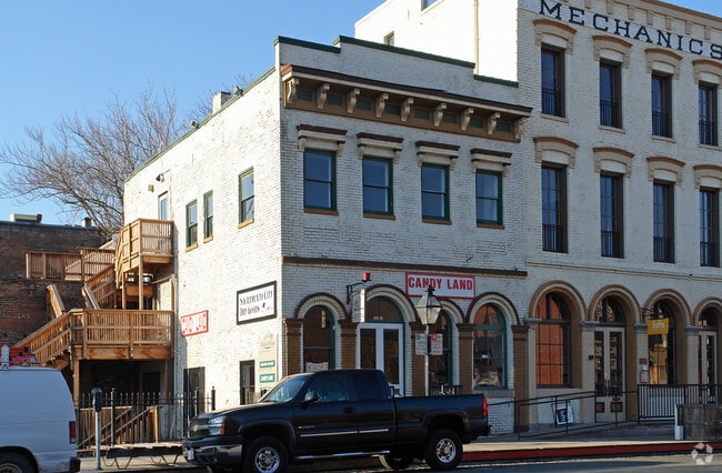
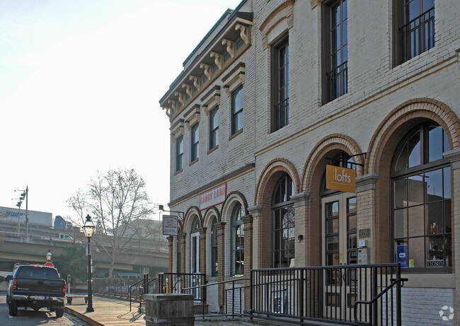
Property Record
122 I St, Sacramento, CA 95814

NEARBY LISTINGS FOR SALE OR LEASE
Property Detail
122 I St
Sacramento--Roseville--Arden-Arcade, CA
Blocks Bounder By I-L & By The Embarcade
006-0012-036
E25.14FT PCL 2 IN PM 3 21 EXC S9FT AL
Storesoffices
Sacramento
X
California
06067C0160J
2
2024
0.44 AC
2025
DTown/Midtown/E Sac
000700
Sacramento
7,195 SF
DEMOGRAPHICS near 122 I St
1 Mile
3 Mile
5 Mile
2024 Total Population
17,218
148,840
330,925
2029 Population
17,621
150,921
335,179
Pop Growth 2024-2029
+ 2.34%
+ 1.40%
+ 1.29%
Average Age
40
39
38
2024 Total Households
7,833
64,073
130,992
HH Growth 2024-2029
+ 2.86%
+ 1.63%
+ 1.40%
Median Household Inc
$50,203
$74,384
$73,522
Avg Household Size
1.80
2.10
2.40
2024 Avg HH Vehicles
1.00
2.00
2.00
Median Home Value
$476,530
$518,482
$484,707
Median Year Built
1976
1970
1970
Nearby Places
Map Layers
Map Styles
 Street
 Aerial
- Restaurants
- Banks
- Shops
- Fitness
- Groceries
PUBLIC TRANSPORTATION
TRANSIT/SUBWAY
Sacramento Valley Station (Gold Line - Sacramento Regional Transit District Light Rail (The RT))
DRIVE
WALK
Distance
Sacramento Valley Station (Gold Line - Sacramento Regional Transit District Light Rail (The RT))
2 min
7 min
0.4 mi
7th & I/County Center (Gold Line - Sacramento Regional Transit District Light Rail (The RT))
DRIVE
WALK
Distance
7th & I/County Center (Gold Line - Sacramento Regional Transit District Light Rail (The RT))
2 min
9 min
0.5 mi
8th & K (Gold Line - Sacramento Regional Transit District Light Rail (The RT))
DRIVE
WALK
Distance
8th & K (Gold Line - Sacramento Regional Transit District Light Rail (The RT))
3 min
12 min
0.6 mi
St. Rose of Lima Park - 9th & K (Blue Line - Sacramento Regional Transit District Light Rail (The RT))
DRIVE
WALK
Distance
St. Rose of Lima Park - 9th & K (Blue Line - Sacramento Regional Transit District Light Rail (The RT))
2 min
13 min
0.7 mi
7th & Capitol (Blue Line - Sacramento Regional Transit District Light Rail (The RT), Gold Line - Sacramento Regional Transit District Light Rail (The RT))
DRIVE
WALK
Distance
7th & Capitol (Blue Line - Sacramento Regional Transit District Light Rail (The RT), Gold Line - Sacramento Regional Transit District Light Rail (The RT))
3 min
13 min
0.7 mi
COMMUTER RAIL
DRIVE
WALK
Distance
2 min
5 min
0.3 mi
AIRPORT
Sacramento International
DRIVE
WALK
Distance
Sacramento International
18 min
11.2 mi
Freight Ports
Port of Stockton
DRIVE
WALK
Distance
Port of Stockton
55 min
47.0 mi
SALE & LEASE HISTORY
LISTING DATE
SALE/LEASE

May 17, 2018
For Lease
Nearby Properties
Address
Land Use
TOTAL SIZE
Lot Size
Zoning
Address
Land Use
TOTAL SIZE
Lot Size
Zoning
1,095,507 SF
1.39 AC
H-SPD C-2-
Address
Land Use
TOTAL SIZE
Lot Size
Zoning
5.64 AC
C-3-SPD
Address
Land Use
TOTAL SIZE
Lot Size
Zoning
10.28 AC
H
Address
Land Use
TOTAL SIZE
Lot Size
Zoning
487,483 SF
1.12 AC
C-3-SPD
Address
Land Use
TOTAL SIZE
Lot Size
Zoning
756,831 SF
1.39 AC
C-2-SPD
Address
Land Use
TOTAL SIZE
Lot Size
Zoning
399,626 SF
2.41 AC
C-3-SPD
Address
Land Use
TOTAL SIZE
Lot Size
Zoning
366,730 SF
0.89 AC
C-3-SPD
Address
Land Use
TOTAL SIZE
Lot Size
Zoning
200,616 SF
2.54 AC
C-2-SPD
Address
Land Use
TOTAL SIZE
Lot Size
Zoning
594,942 SF
2.39 AC
C-3-SPD
Address
Land Use
TOTAL SIZE
Lot Size
Zoning
676,447 SF
1.43 AC
C-3-SPD
Address
Land Use
TOTAL SIZE
Lot Size
Zoning
193,521 SF
0.60 AC
C-3-SPD
Address
Land Use
TOTAL SIZE
Lot Size
Zoning
339,329 SF
6.40 AC
R-5-PUD-SP
Address
Land Use
TOTAL SIZE
Lot Size
Zoning
213,557 SF
2.33 AC
C-3-SPD
Address
Land Use
TOTAL SIZE
Lot Size
Zoning
0.65 AC
C-4-SPD
Address
Land Use
TOTAL SIZE
Lot Size
Zoning
467,970 SF
4.59 AC
W-F
Address
Land Use
TOTAL SIZE
Lot Size
Zoning
410,420 SF
0.95 AC
C-3-SPD
Address
Land Use
TOTAL SIZE
Lot Size
Zoning
320,072 SF
2.65 AC
C-2
Address
Land Use
TOTAL SIZE
Lot Size
Zoning
318,616 SF
16.40 AC
R-2B-PUD
Address
Land Use
TOTAL SIZE
Lot Size
Zoning
R-4-PUD C-
Address
Land Use
TOTAL SIZE
Lot Size
Zoning
0.13 AC
WF
Address
Land Use
TOTAL SIZE
Lot Size
Zoning
26,712 SF
1.90 AC
R-5-PUD-SP
Address
Land Use
TOTAL SIZE
Lot Size
Zoning
26,712 SF
1.85 AC
R-5-PUD-SP
Address
Land Use
TOTAL SIZE
Lot Size
Zoning
2.88 AC
C-3-SPD
Address
Land Use
TOTAL SIZE
Lot Size
Zoning
508,916 SF
0.71 AC
C-3-SPD
Address
Land Use
TOTAL SIZE
Lot Size
Zoning
303,254 SF
10.63 AC
OB-PUD
Address
Land Use
TOTAL SIZE
Lot Size
Zoning
246,417 SF
1.19 AC
C-3-SPD
Address
Land Use
TOTAL SIZE
Lot Size
Zoning
405,074 SF
2.39 AC
C-3-SPD
Address
Land Use
TOTAL SIZE
Lot Size
Zoning
119,055 SF
1.18 AC
C-2-SPD
Address
Land Use
TOTAL SIZE
Lot Size
Zoning
383,000 SF
25.52 AC
M-1
Address
Land Use
TOTAL SIZE
Lot Size
Zoning
0.90 AC
C-3-SPD
The World's #1 Commercial Real Estate Marketplace
Connect with us
© 2026 CoStar Group
The information above has been obtained from sources believed reliable. While we do not doubt its accuracy we have not verified it and make no guarantee, warranty or representation about it. It is your responsibility to independently confirm its accuracy and completeness. Any projections, opinions, assumptions, or estimates used are for example only and do not represent the current or future performance of the property. The value of this transaction to you depends on tax and other factors which should be evaluated by your tax, financial, and legal advisors. You and your advisors should conduct a careful, independent investigation of the property to determine to your satisfaction the suitability of the property for your needs.