Property Record
900 Nw 36Th St, Miami, FL 33127
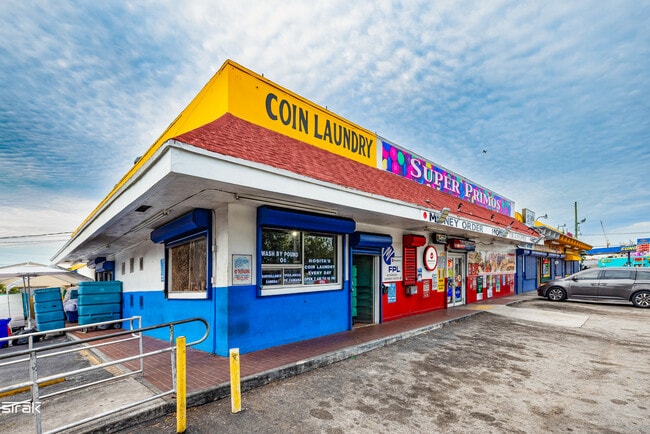
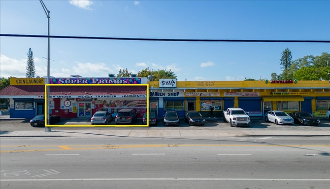

This Property Is For Sale
NEARBY LISTINGS FOR SALE OR LEASE
Property Detail
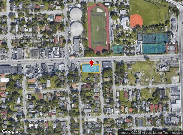
900 Nw 36Th St
Miami-Miami Beach-Kendall, FL
Buena Vista Park
01-3126-030-0170
BUENA VISTA PARK PB 4-170 LOTS 9 & 10 LESS N10FT & LESS E5FT & LOT 11 LESS W5FT & LESS EXT AREA OF CURVE IN NW COR & LOT 12 LESS W5FT BLK 2 LOT SIZE 22800 SQ FT OR 19384-0602/20132-4720 1201 4 COC 23810-3118 11 2004 1
Storemultistory
Miami/Dade
X
Florida
12086C0312L
9-12
2024
0.52 AC
2025
Miami
002202
South Florida
11,193 SF
DEMOGRAPHICS near 900 Nw 36Th St
1 Mile
3 Mile
5 Mile
2024 Total Population
27,139
279,505
591,551
2029 Population
26,661
277,634
583,037
Pop Growth 2024-2029
(1.76%)
(0.67%)
(1.44%)
Average Age
39
39
41
2024 Total Households
9,045
113,680
241,284
HH Growth 2024-2029
(2.00%)
(0.56%)
(1.42%)
Median Household Inc
$38,260
$41,341
$50,846
Avg Household Size
2.80
2.30
2.30
2024 Avg HH Vehicles
1.00
1.00
1.00
Median Home Value
$356,220
$361,278
$394,899
Median Year Built
1960
1979
1974
Nearby Places
Map Layers
Map Styles
 Street
 Aerial
- Restaurants
- Banks
- Shops
- Fitness
- Groceries
PUBLIC TRANSPORTATION
TRANSIT/SUBWAY
Allapattah (Metrorail Green Line - Miami-Dade Transit (Metrorail/Metromover))
DRIVE
WALK
Distance
Allapattah (Metrorail Green Line - Miami-Dade Transit (Metrorail/Metromover))
2 min
7 min
0.4 mi
COMMUTER RAIL
Allapattah (Metrorail Green Line - Miami-Dade Transit (Metrorail/Metromover))
DRIVE
WALK
Distance
Allapattah (Metrorail Green Line - Miami-Dade Transit (Metrorail/Metromover))
2 min
7 min
0.4 mi
Santa Clara (Metrorail Green Line - Miami-Dade Transit (Metrorail/Metromover))
DRIVE
WALK
Distance
Santa Clara (Metrorail Green Line - Miami-Dade Transit (Metrorail/Metromover))
3 min
1.2 mi
AIRPORT
Miami International
DRIVE
WALK
Distance
Miami International
20 min
8.6 mi
Fort Lauderdale/Hollywood International
DRIVE
WALK
Distance
Fort Lauderdale/Hollywood International
32 min
20.8 mi
Freight Ports
Port of Miami
DRIVE
WALK
Distance
Port of Miami
12 min
5.2 mi
Nearby Properties
Address
Land Use
TOTAL SIZE
Lot Size
Zoning
Address
Land Use
TOTAL SIZE
Lot Size
Zoning
955,966 SF
38.91 AC
9600
Address
Land Use
TOTAL SIZE
Lot Size
Zoning
2,039,308 SF
2.46 AC
6401
Address
Land Use
TOTAL SIZE
Lot Size
Zoning
928,000 SF
14.30 AC
8000
Address
Land Use
TOTAL SIZE
Lot Size
Zoning
16.13 AC
6100
Address
Land Use
TOTAL SIZE
Lot Size
Zoning
2,403,353 SF
7.37 AC
6100
Address
Land Use
TOTAL SIZE
Lot Size
Zoning
1,938,271 SF
6.62 AC
6402
Address
Land Use
TOTAL SIZE
Lot Size
Zoning
1,075,124 SF
1.61 AC
6405
Address
Land Use
TOTAL SIZE
Lot Size
Zoning
1,544,491 SF
0.97 AC
6401
Address
Land Use
TOTAL SIZE
Lot Size
Zoning
1,657,362 SF
1.15 AC
6401
Address
Land Use
TOTAL SIZE
Lot Size
Zoning
244,533 SF
3.53 AC
6600
Address
Land Use
TOTAL SIZE
Lot Size
Zoning
303,989 SF
1.47 AC
6600
Address
Land Use
TOTAL SIZE
Lot Size
Zoning
416,675 SF
6.48 AC
6401
Address
Land Use
TOTAL SIZE
Lot Size
Zoning
256,089 SF
20.35 AC
7600
Address
Land Use
TOTAL SIZE
Lot Size
Zoning
1,004,006 SF
0.92 AC
6401
Address
Land Use
TOTAL SIZE
Lot Size
Zoning
585,775 SF
1.86 AC
6101
Address
Land Use
TOTAL SIZE
Lot Size
Zoning
868,860 SF
2.14 AC
6402
Address
Land Use
TOTAL SIZE
Lot Size
Zoning
491,308 SF
0.14 AC
6401
Address
Land Use
TOTAL SIZE
Lot Size
Zoning
903,993 SF
0.60 AC
6412
Address
Land Use
TOTAL SIZE
Lot Size
Zoning
872,245 SF
0.56 AC
6401
Address
Land Use
TOTAL SIZE
Lot Size
Zoning
615,785 SF
3.81 AC
4604
Address
Land Use
TOTAL SIZE
Lot Size
Zoning
2 AC
8000
Address
Land Use
TOTAL SIZE
Lot Size
Zoning
1,262,330 SF
1.39 AC
6402
Address
Land Use
TOTAL SIZE
Lot Size
Zoning
616,963 SF
0.75 AC
6401
Address
Land Use
TOTAL SIZE
Lot Size
Zoning
845,870 SF
1.30 AC
6412
Address
Land Use
TOTAL SIZE
Lot Size
Zoning
790,139 SF
1.80 AC
6110
Address
Land Use
TOTAL SIZE
Lot Size
Zoning
604,146 SF
5.66 AC
6600
Address
Land Use
TOTAL SIZE
Lot Size
Zoning
656,110 SF
1.75 AC
6401
Address
Land Use
TOTAL SIZE
Lot Size
Zoning
570,694 SF
1.37 AC
4604
Address
Land Use
TOTAL SIZE
Lot Size
Zoning
655,148 SF
0.30 AC
6401
Address
Land Use
TOTAL SIZE
Lot Size
Zoning
990,766 SF
1.16 AC
6420
The World's #1 Commercial Real Estate Marketplace
Connect with us
© 2026 CoStar Group
The information above has been obtained from sources believed reliable. While we do not doubt its accuracy we have not verified it and make no guarantee, warranty or representation about it. It is your responsibility to independently confirm its accuracy and completeness. Any projections, opinions, assumptions, or estimates used are for example only and do not represent the current or future performance of the property. The value of this transaction to you depends on tax and other factors which should be evaluated by your tax, financial, and legal advisors. You and your advisors should conduct a careful, independent investigation of the property to determine to your satisfaction the suitability of the property for your needs.