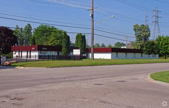
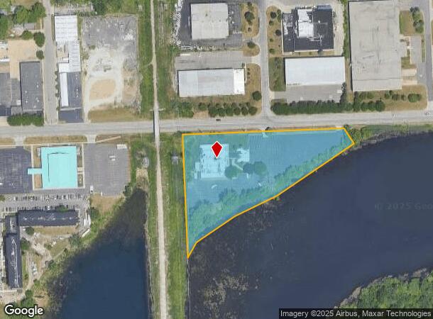
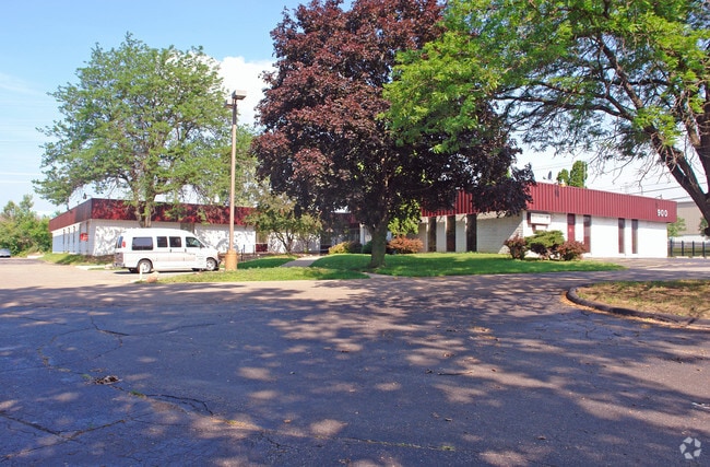
Property Record
900 Auburn Ave, Pontiac, MI 48342
This Property Is For Sale
NEARBY LISTINGS FOR SALE OR LEASE
Property Detail
900 Auburn Ave
Detroit-Warren-Dearborn, MI
Spring Lake
14-34-201-009
T3N, R10E, SEC 34 ASSESSOR'S PLAT NO 141 PART OF LOT 1 BEG AT NW LOT COR, TH N 88-03-50 E 662.34 FT, TH S 14-46-12 E 73.90
Officebuilding
Oakland
X
Michigan
26125C0369F
1
2024
4.22 AC
2025
Pontiac
142300
Detroit
19,015 SF
DEMOGRAPHICS near 900 Auburn Ave
1 Mile
3 Mile
5 Mile
2024 Total Population
6,788
68,041
161,908
2029 Population
6,843
68,074
161,389
Pop Growth 2024-2029
+ 0.81%
+ 0.05%
(0.32%)
Average Age
37
39
41
2024 Total Households
2,827
27,217
64,973
HH Growth 2024-2029
+ 0.78%
(0.03%)
(0.35%)
Median Household Inc
$27,226
$51,320
$67,591
Avg Household Size
2.30
2.40
2.40
2024 Avg HH Vehicles
1.00
2.00
2.00
Median Home Value
$86,797
$169,147
$281,607
Median Year Built
1965
1966
1971
Nearby Places
Map Layers
Map Styles
 Street
 Aerial
- Restaurants
- Banks
- Shops
- Fitness
- Groceries
PUBLIC TRANSPORTATION
AIRPORT
Windsor International
DRIVE
WALK
Distance
Windsor International
58 min
38.4 mi
Bishop International
DRIVE
WALK
Distance
Bishop International
59 min
42.6 mi
Detroit Metro Wayne County
DRIVE
WALK
Distance
Detroit Metro Wayne County
62 min
47.9 mi
Nearby Properties
Address
Land Use
TOTAL SIZE
Lot Size
Zoning
Address
Land Use
TOTAL SIZE
Lot Size
Zoning
7,879,586 SF
457.68 AC
TR
Address
Land Use
TOTAL SIZE
Lot Size
Zoning
2,734,739 SF
80.39 AC
Address
Land Use
TOTAL SIZE
Lot Size
Zoning
671,780 SF
Address
Land Use
TOTAL SIZE
Lot Size
Zoning
238,755 SF
Address
Land Use
TOTAL SIZE
Lot Size
Zoning
526,398 SF
32.99 AC
Address
Land Use
TOTAL SIZE
Lot Size
Zoning
715,400 SF
Address
Land Use
TOTAL SIZE
Lot Size
Zoning
711,360 SF
43.86 AC
Address
Land Use
TOTAL SIZE
Lot Size
Zoning
453,700 SF
Address
Land Use
TOTAL SIZE
Lot Size
Zoning
404,427 SF
28.15 AC
TR
Address
Land Use
TOTAL SIZE
Lot Size
Zoning
608,251 SF
50.49 AC
II
Address
Land Use
TOTAL SIZE
Lot Size
Zoning
238,755 SF
18.12 AC
Address
Land Use
TOTAL SIZE
Lot Size
Zoning
1,771,589 SF
96.73 AC
Address
Land Use
TOTAL SIZE
Lot Size
Zoning
337,992 SF
18.96 AC
TR
Address
Land Use
TOTAL SIZE
Lot Size
Zoning
104,434 SF
8.64 AC
Address
Land Use
TOTAL SIZE
Lot Size
Zoning
487,797 SF
34.74 AC
TR
Address
Land Use
TOTAL SIZE
Lot Size
Zoning
278,387 SF
43.37 AC
Address
Land Use
TOTAL SIZE
Lot Size
Zoning
131,817 SF
67 AC
SP
Address
Land Use
TOTAL SIZE
Lot Size
Zoning
374,400 SF
4.10 AC
Address
Land Use
TOTAL SIZE
Lot Size
Zoning
214,772 SF
Address
Land Use
TOTAL SIZE
Lot Size
Zoning
601,151 SF
Address
Land Use
TOTAL SIZE
Lot Size
Zoning
337,992 SF
Address
Land Use
TOTAL SIZE
Lot Size
Zoning
144,349 SF
12.42 AC
SP
Address
Land Use
TOTAL SIZE
Lot Size
Zoning
360,186 SF
38.44 AC
RM2
Address
Land Use
TOTAL SIZE
Lot Size
Zoning
210,000 SF
14.46 AC
TR
Address
Land Use
TOTAL SIZE
Lot Size
Zoning
321,936 SF
29.11 AC
RM1
Address
Land Use
TOTAL SIZE
Lot Size
Zoning
101,409 SF
5.90 AC
Address
Land Use
TOTAL SIZE
Lot Size
Zoning
172,076 SF
11.18 AC
Address
Land Use
TOTAL SIZE
Lot Size
Zoning
278,387 SF
Address
Land Use
TOTAL SIZE
Lot Size
Zoning
64,217 SF
39.13 AC
Address
Land Use
TOTAL SIZE
Lot Size
Zoning
206,590 SF
6.14 AC
RI
The World's #1 Commercial Real Estate Marketplace
Connect with us
© 2026 CoStar Group
The information above has been obtained from sources believed reliable. While we do not doubt its accuracy we have not verified it and make no guarantee, warranty or representation about it. It is your responsibility to independently confirm its accuracy and completeness. Any projections, opinions, assumptions, or estimates used are for example only and do not represent the current or future performance of the property. The value of this transaction to you depends on tax and other factors which should be evaluated by your tax, financial, and legal advisors. You and your advisors should conduct a careful, independent investigation of the property to determine to your satisfaction the suitability of the property for your needs.