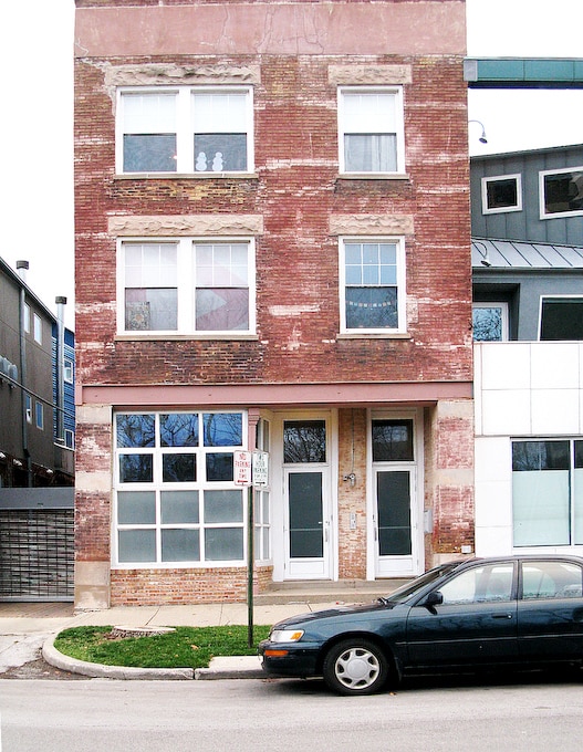
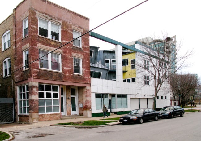
Property Record
900 Grove St, Winnetka, IL 60093
NEARBY LISTINGS FOR SALE OR LEASE
Property Detail
900 Grove St
05-18-105-001-0000
Cook
Taxexempt
Illinois
A
115 AC
17031C0232J
Near North
0
Chicago
2024
Chicago-Naperville-Elgin, IL-IN-WI
800500
DEMOGRAPHICS near 900 Grove St
1 Mile
3 Mile
5 Mile
2024 Total Population
38,702
186,586
439,886
2029 Population
37,809
181,329
427,677
Pop Growth 2024-2029
(2.31%)
(2.82%)
(2.78%)
Average Age
38
40
41
2024 Total Households
16,203
74,387
176,400
HH Growth 2024-2029
(2.25%)
(3.03%)
(3.01%)
Median Household Inc
$72,627
$77,597
$72,439
Avg Household Size
2.00
2.30
2.30
2024 Avg HH Vehicles
1.00
1.00
1.00
Median Home Value
$435,963
$406,506
$389,407
Median Year Built
1956
1951
1952
Nearby Places
Map Layers
Map Styles
 Street
 Aerial
- Restaurants
- Banks
- Shops
- Fitness
- Groceries
PUBLIC TRANSPORTATION
COMMUTER RAIL
Hubbard Woods Station (Union Pacific North Line - Northeast Illinois Regional Commuter Railroad (Metra))
DRIVE
WALK
Distance
Hubbard Woods Station (Union Pacific North Line - Northeast Illinois Regional Commuter Railroad (Metra))
4 min
1.4 mi
Glencoe Station (Union Pacific North Line - Northeast Illinois Regional Commuter Railroad (Metra))
DRIVE
WALK
Distance
Glencoe Station (Union Pacific North Line - Northeast Illinois Regional Commuter Railroad (Metra))
5 min
2.7 mi
AIRPORT
Chicago O'Hare International
DRIVE
WALK
Distance
Chicago O'Hare International
29 min
18.0 mi
Chicago Midway International
DRIVE
WALK
Distance
Chicago Midway International
42 min
26.5 mi
Freight Ports
Port Milwaukee
DRIVE
WALK
Distance
Port Milwaukee
79 min
66.4 mi
Nearby Properties
Address
Land Use
TOTAL SIZE
Lot Size
Zoning
Address
Land Use
TOTAL SIZE
Lot Size
Zoning
8.04 AC
Address
Land Use
TOTAL SIZE
Lot Size
Zoning
629,447 SF
3.96 AC
Address
Land Use
TOTAL SIZE
Lot Size
Zoning
679,109 SF
24.46 AC
Address
Land Use
TOTAL SIZE
Lot Size
Zoning
579,162 SF
6.41 AC
Address
Land Use
TOTAL SIZE
Lot Size
Zoning
14.11 AC
Address
Land Use
TOTAL SIZE
Lot Size
Zoning
333,202 SF
13.88 AC
Address
Land Use
TOTAL SIZE
Lot Size
Zoning
172,538 SF
5.60 AC
Address
Land Use
TOTAL SIZE
Lot Size
Zoning
167,843 SF
12.55 AC
Address
Land Use
TOTAL SIZE
Lot Size
Zoning
215,633 SF
9.78 AC
Address
Land Use
TOTAL SIZE
Lot Size
Zoning
193,804 SF
7.98 AC
Address
Land Use
TOTAL SIZE
Lot Size
Zoning
149,716 SF
6.02 AC
Address
Land Use
TOTAL SIZE
Lot Size
Zoning
58,280 SF
3.46 AC
Address
Land Use
TOTAL SIZE
Lot Size
Zoning
6.90 AC
Address
Land Use
TOTAL SIZE
Lot Size
Zoning
230,886 SF
9.30 AC
Address
Land Use
TOTAL SIZE
Lot Size
Zoning
1.37 AC
Address
Land Use
TOTAL SIZE
Lot Size
Zoning
154,086 SF
5.90 AC
Address
Land Use
TOTAL SIZE
Lot Size
Zoning
109,192 SF
3.64 AC
Address
Land Use
TOTAL SIZE
Lot Size
Zoning
169,657 SF
7.25 AC
Address
Land Use
TOTAL SIZE
Lot Size
Zoning
Address
Land Use
TOTAL SIZE
Lot Size
Zoning
71,565 SF
6.17 AC
Address
Land Use
TOTAL SIZE
Lot Size
Zoning
172,544 SF
7.22 AC
Address
Land Use
TOTAL SIZE
Lot Size
Zoning
160,166 SF
5.67 AC
Address
Land Use
TOTAL SIZE
Lot Size
Zoning
126,621 SF
3.03 AC
Address
Land Use
TOTAL SIZE
Lot Size
Zoning
148,663 SF
13.77 AC
Address
Land Use
TOTAL SIZE
Lot Size
Zoning
60,301 SF
3.35 AC
Address
Land Use
TOTAL SIZE
Lot Size
Zoning
128,372 SF
5.21 AC
Address
Land Use
TOTAL SIZE
Lot Size
Zoning
136,352 SF
10.39 AC
Address
Land Use
TOTAL SIZE
Lot Size
Zoning
78,819 SF
5.86 AC
Address
Land Use
TOTAL SIZE
Lot Size
Zoning
135,000 SF
3.59 AC
Address
Land Use
TOTAL SIZE
Lot Size
Zoning
120,000 SF
8.31 AC
The World's #1 Commercial Real Estate Marketplace
Connect with us
© 2025 CoStar Group
The information above has been obtained from sources believed reliable. While we do not doubt its accuracy we have not verified it and make no guarantee, warranty or representation about it. It is your responsibility to independently confirm its accuracy and completeness. Any projections, opinions, assumptions, or estimates used are for example only and do not represent the current or future performance of the property. The value of this transaction to you depends on tax and other factors which should be evaluated by your tax, financial, and legal advisors. You and your advisors should conduct a careful, independent investigation of the property to determine to your satisfaction the suitability of the property for your needs.