Property Record
900 Kings Hwy, Punta Gorda, FL 33980

NEARBY LISTINGS FOR SALE OR LEASE
Property Detail
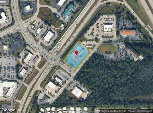
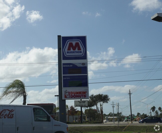
900 Kings Hwy
402307127002
Brookfield Commons
Servicestationmarket
07 40 23 P-1-3 1.68 AC M/L COMM AT NW COR SEC 7 THE E 2295.74 FT SW .64 FT FOR POB TH SE 221.78 FT SW 333.58 FT NW 209.57 FT NE 345.37 FT TO POB AKA PARCEL 1-3 896/1627 E896/1629 RES70-1638 CD1025/2078 1441/1567 2096/1583 CD2197/937 2514/350
X
Charlotte
12015C0068G
Florida
2024
1.68 AC
2025
Charlotte County
020104
Southwest Florida
10,980 SF
Punta Gorda, FL
DEMOGRAPHICS near 900 Kings Hwy
1 Mile
3 Mile
5 Mile
2024 Total Population
6,092
42,367
82,326
2029 Population
7,307
50,413
97,876
Pop Growth 2024-2029
+ 19.94%
+ 18.99%
+ 18.89%
Average Age
56
51
50
2024 Total Households
3,096
18,906
36,603
HH Growth 2024-2029
+ 20.45%
+ 19.37%
+ 19.28%
Median Household Inc
$66,310
$60,812
$56,048
Avg Household Size
1.90
2.20
2.20
2024 Avg HH Vehicles
2.00
2.00
2.00
Median Home Value
$235,085
$231,526
$222,430
Median Year Built
2002
1990
1986
Nearby Places
Map Layers
Map Styles
 Street
 Aerial
- Restaurants
- Banks
- Shops
- Fitness
- Groceries
PUBLIC TRANSPORTATION
AIRPORT
Punta Gorda
DRIVE
WALK
Distance
Punta Gorda
15 min
9.8 mi
Nearby Properties
Address
Land Use
TOTAL SIZE
Lot Size
Zoning
Address
Land Use
TOTAL SIZE
Lot Size
Zoning
202,009 SF
20.89 AC
PD
Address
Land Use
TOTAL SIZE
Lot Size
Zoning
204,731 SF
16.11 AC
PD
Address
Land Use
TOTAL SIZE
Lot Size
Zoning
229,973 SF
21.33 AC
PD
Address
Land Use
TOTAL SIZE
Lot Size
Zoning
249,777 SF
48 AC
RMF10
Address
Land Use
TOTAL SIZE
Lot Size
Zoning
217,784 SF
38.63 AC
PD
Address
Land Use
TOTAL SIZE
Lot Size
Zoning
139,109 SF
23.44 AC
CG
Address
Land Use
TOTAL SIZE
Lot Size
Zoning
102,337 SF
10.43 AC
RSF3.5
Address
Land Use
TOTAL SIZE
Lot Size
Zoning
73,222 SF
5.14 AC
PD
Address
Land Use
TOTAL SIZE
Lot Size
Zoning
50,970 SF
9.74 AC
RSF3.5
Address
Land Use
TOTAL SIZE
Lot Size
Zoning
41,148 SF
155.85 AC
RSF-3
Address
Land Use
TOTAL SIZE
Lot Size
Zoning
83,180 SF
9.31 AC
PD
Address
Land Use
TOTAL SIZE
Lot Size
Zoning
95,547 SF
14.06 AC
PD
Address
Land Use
TOTAL SIZE
Lot Size
Zoning
125.54 AC
PD
Address
Land Use
TOTAL SIZE
Lot Size
Zoning
35,951 SF
24.23 AC
PD
Address
Land Use
TOTAL SIZE
Lot Size
Zoning
35,587 SF
6.27 AC
RMF15
Address
Land Use
TOTAL SIZE
Lot Size
Zoning
27,082 SF
2.05 AC
PD
Address
Land Use
TOTAL SIZE
Lot Size
Zoning
84,500 SF
5.59 AC
CG
Address
Land Use
TOTAL SIZE
Lot Size
Zoning
86,773 SF
5.07 AC
IG
Address
Land Use
TOTAL SIZE
Lot Size
Zoning
23,798 SF
1.71 AC
PD
Address
Land Use
TOTAL SIZE
Lot Size
Zoning
98,552 SF
11.42 AC
CG
Address
Land Use
TOTAL SIZE
Lot Size
Zoning
51,248 SF
15.96 AC
PD
Address
Land Use
TOTAL SIZE
Lot Size
Zoning
82.27 AC
PD
Address
Land Use
TOTAL SIZE
Lot Size
Zoning
21.61 AC
PD
Address
Land Use
TOTAL SIZE
Lot Size
Zoning
81,226 SF
11.40 AC
OMI
Address
Land Use
TOTAL SIZE
Lot Size
Zoning
12,977 SF
2.29 AC
PD
Address
Land Use
TOTAL SIZE
Lot Size
Zoning
13,642 SF
2.55 AC
PD
Address
Land Use
TOTAL SIZE
Lot Size
Zoning
36,798 SF
19.40 AC
RSF3.5
Address
Land Use
TOTAL SIZE
Lot Size
Zoning
34,983 SF
18.79 AC
RE1
Address
Land Use
TOTAL SIZE
Lot Size
Zoning
11,773 SF
1.55 AC
PD
Address
Land Use
TOTAL SIZE
Lot Size
Zoning
7.81 AC
PD
The World's #1 Commercial Real Estate Marketplace
Connect with us
© 2025 CoStar Group
The information above has been obtained from sources believed reliable. While we do not doubt its accuracy we have not verified it and make no guarantee, warranty or representation about it. It is your responsibility to independently confirm its accuracy and completeness. Any projections, opinions, assumptions, or estimates used are for example only and do not represent the current or future performance of the property. The value of this transaction to you depends on tax and other factors which should be evaluated by your tax, financial, and legal advisors. You and your advisors should conduct a careful, independent investigation of the property to determine to your satisfaction the suitability of the property for your needs.