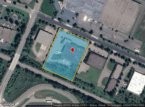
Property Record
900 Mckinley St, Anoka, MN 55303
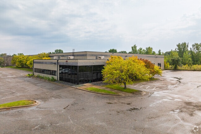
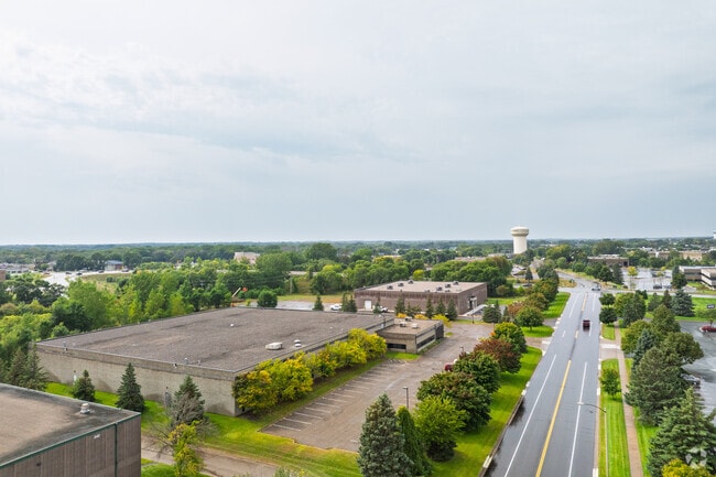
This Property Is For Sale
Current Lease Availabilities
NEARBY LISTINGS FOR SALE OR LEASE
Property Detail
900 Mckinley St
Minneapolis-St. Paul-Bloomington, MN-WI
Anoka Enterprise Park Se
35-32-25-41-0018
LOT 2 BLOCK 1 ANOKA ENTERPRISE PARK SE
Industrialgeneral
Anoka
X
Minnesota
27053C0058F
2
2024
4.36 AC
2025
North Central
050401
Minneapolis/St Paul
48,840 SF
DEMOGRAPHICS near 900 Mckinley St
1 Mile
3 Mile
5 Mile
2024 Total Population
5,167
53,231
109,869
2029 Population
5,363
54,997
112,639
Pop Growth 2024-2029
+ 3.79%
+ 3.32%
+ 2.52%
Average Age
40
40
40
2024 Total Households
2,158
20,547
41,019
HH Growth 2024-2029
+ 3.80%
+ 3.40%
+ 2.58%
Median Household Inc
$73,372
$87,558
$92,826
Avg Household Size
2.30
2.50
2.60
2024 Avg HH Vehicles
2.00
2.00
2.00
Median Home Value
$259,307
$301,954
$304,236
Median Year Built
1986
1988
1986
Nearby Places
- Restaurants
- Banks
- Shops
- Fitness
- Groceries
PUBLIC TRANSPORTATION
COMMUTER RAIL
Anoka Station (Northstar Corridor - Northstar Commuter Rail)
DRIVE
WALK
Distance
Anoka Station (Northstar Corridor - Northstar Commuter Rail)
6 min
2.6 mi
Ramsey Station & Platform (Northstar Commuter Rail - Metro Transit)
DRIVE
WALK
Distance
Ramsey Station & Platform (Northstar Commuter Rail - Metro Transit)
7 min
3.6 mi
AIRPORT
Minneapolis-St Paul International/Wold-Chamberlain
DRIVE
WALK
Distance
Minneapolis-St Paul International/Wold-Chamberlain
49 min
34.6 mi
Freight Ports
Port Milwaukee
DRIVE
WALK
Distance
Port Milwaukee
394 min
356.8 mi
Nearby Properties
Address
Land Use
TOTAL SIZE
Lot Size
Zoning
Address
Land Use
TOTAL SIZE
Lot Size
Zoning
468,099 SF
5.73 AC
MSMU
Address
Land Use
TOTAL SIZE
Lot Size
Zoning
3.80 AC
Address
Land Use
TOTAL SIZE
Lot Size
Zoning
3,491 SF
3.03 AC
Address
Land Use
TOTAL SIZE
Lot Size
Zoning
2,400 SF
72.45 AC
Address
Land Use
TOTAL SIZE
Lot Size
Zoning
5,110 SF
38.62 AC
Address
Land Use
TOTAL SIZE
Lot Size
Zoning
122,816 SF
27.84 AC
Address
Land Use
TOTAL SIZE
Lot Size
Zoning
363,449 SF
82.99 AC
R-1
Address
Land Use
TOTAL SIZE
Lot Size
Zoning
68,362 SF
Address
Land Use
TOTAL SIZE
Lot Size
Zoning
225,748 SF
Address
Land Use
TOTAL SIZE
Lot Size
Zoning
129,060 SF
10.21 AC
Address
Land Use
TOTAL SIZE
Lot Size
Zoning
382,508 SF
Address
Land Use
TOTAL SIZE
Lot Size
Zoning
343,297 SF
25.42 AC
M-1
Address
Land Use
TOTAL SIZE
Lot Size
Zoning
153,964 SF
3.90 AC
Address
Land Use
TOTAL SIZE
Lot Size
Zoning
168,887 SF
7.01 AC
Address
Land Use
TOTAL SIZE
Lot Size
Zoning
140,288 SF
5.12 AC
Address
Land Use
TOTAL SIZE
Lot Size
Zoning
300,547 SF
19.21 AC
Address
Land Use
TOTAL SIZE
Lot Size
Zoning
298,148 SF
17.70 AC
M-1
Address
Land Use
TOTAL SIZE
Lot Size
Zoning
319,019 SF
17.14 AC
Address
Land Use
TOTAL SIZE
Lot Size
Zoning
114,281 SF
3.19 AC
PRD-4
Address
Land Use
TOTAL SIZE
Lot Size
Zoning
319,664 SF
19.62 AC
M-1
Address
Land Use
TOTAL SIZE
Lot Size
Zoning
436,117 SF
17.75 AC
M-1
Address
Land Use
TOTAL SIZE
Lot Size
Zoning
190,285 SF
12.98 AC
Address
Land Use
TOTAL SIZE
Lot Size
Zoning
Address
Land Use
TOTAL SIZE
Lot Size
Zoning
118,208 SF
Address
Land Use
TOTAL SIZE
Lot Size
Zoning
Address
Land Use
TOTAL SIZE
Lot Size
Zoning
155,849 SF
0.83 AC
Address
Land Use
TOTAL SIZE
Lot Size
Zoning
201,859 SF
9.21 AC
Address
Land Use
TOTAL SIZE
Lot Size
Zoning
811,860 SF
Address
Land Use
TOTAL SIZE
Lot Size
Zoning
100 SF
5.42 AC
R-2
Address
Land Use
TOTAL SIZE
Lot Size
Zoning
60,588 SF
4.56 AC
The World's #1 Commercial Real Estate Marketplace
Connect with us
© 2025 CoStar Group
The information above has been obtained from sources believed reliable. While we do not doubt its accuracy we have not verified it and make no guarantee, warranty or representation about it. It is your responsibility to independently confirm its accuracy and completeness. Any projections, opinions, assumptions, or estimates used are for example only and do not represent the current or future performance of the property. The value of this transaction to you depends on tax and other factors which should be evaluated by your tax, financial, and legal advisors. You and your advisors should conduct a careful, independent investigation of the property to determine to your satisfaction the suitability of the property for your needs.