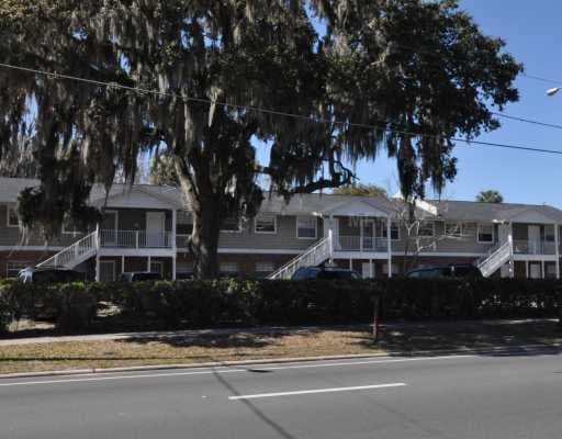
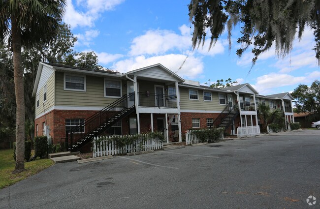
Property Record
900 N Bay St, Eustis, FL 32726

NEARBY LISTINGS FOR SALE OR LEASE
-
-
View all Eustis listings for sale on LoopNet.com
Property Detail
900 N Bay St
Orlando-Kissimmee-Sanford, FL
Northshore
02-19-26-0300-001-00100
EUSTIS NORTHSHORE PB 5 PG 64 LOTS 1 2 BLK 1 ORB 5389 PG 489
Multifamilydwelling
Lake
X
Florida
12069C0356E
1
2024
0.49 AC
2026
Lake County
030206
Orlando
9,216 SF
DEMOGRAPHICS near 900 N Bay St
1 Mile
3 Mile
5 Mile
2024 Total Population
4,861
28,844
70,059
2029 Population
5,643
33,513
81,739
Pop Growth 2024-2029
+ 16.09%
+ 16.19%
+ 16.67%
Average Age
42
43
45
2024 Total Households
2,008
11,841
29,845
HH Growth 2024-2029
+ 15.94%
+ 15.94%
+ 16.53%
Median Household Inc
$37,808
$57,208
$59,717
Avg Household Size
2.30
2.40
2.30
2024 Avg HH Vehicles
2.00
2.00
2.00
Median Home Value
$161,764
$228,076
$244,309
Median Year Built
1974
1982
1984
Nearby Places
Map Layers
Map Styles
 Street
 Aerial
- Restaurants
- Banks
- Shops
- Fitness
- Groceries
PUBLIC TRANSPORTATION
AIRPORT
Orlando Sanford International
DRIVE
WALK
Distance
Orlando Sanford International
57 min
35.8 mi
Freight Ports
Port Canaveral
DRIVE
WALK
Distance
Port Canaveral
116 min
93.4 mi
SALE & LEASE HISTORY
LISTING DATE
SALE/LEASE

Oct 14, 2019
For Sale
Nearby Properties
Address
Land Use
TOTAL SIZE
Lot Size
Zoning
Address
Land Use
TOTAL SIZE
Lot Size
Zoning
278,266 SF
23.85 AC
PD
Address
Land Use
TOTAL SIZE
Lot Size
Zoning
226,508 SF
19.15 AC
Address
Land Use
TOTAL SIZE
Lot Size
Zoning
158,442 SF
17.50 AC
MCI
Address
Land Use
TOTAL SIZE
Lot Size
Zoning
85,539 SF
9.39 AC
Address
Land Use
TOTAL SIZE
Lot Size
Zoning
135,298 SF
9.22 AC
SR
Address
Land Use
TOTAL SIZE
Lot Size
Zoning
190,551 SF
20.31 AC
GC
Address
Land Use
TOTAL SIZE
Lot Size
Zoning
36,261 SF
6.27 AC
PD
Address
Land Use
TOTAL SIZE
Lot Size
Zoning
174,744 SF
38.45 AC
GI
Address
Land Use
TOTAL SIZE
Lot Size
Zoning
94,435 SF
8.16 AC
GC
Address
Land Use
TOTAL SIZE
Lot Size
Zoning
106,175 SF
8.10 AC
UR
Address
Land Use
TOTAL SIZE
Lot Size
Zoning
77,567 SF
5.14 AC
UR
Address
Land Use
TOTAL SIZE
Lot Size
Zoning
100,117 SF
7.45 AC
GC
Address
Land Use
TOTAL SIZE
Lot Size
Zoning
116,261 SF
5.66 AC
Address
Land Use
TOTAL SIZE
Lot Size
Zoning
60,476 SF
6.76 AC
MCR
Address
Land Use
TOTAL SIZE
Lot Size
Zoning
70,525 SF
37.62 AC
R2
Address
Land Use
TOTAL SIZE
Lot Size
Zoning
44,275 SF
22.50 AC
C1
Address
Land Use
TOTAL SIZE
Lot Size
Zoning
12,573 SF
43.71 AC
A
Address
Land Use
TOTAL SIZE
Lot Size
Zoning
2,000 SF
44.77 AC
CFD
Address
Land Use
TOTAL SIZE
Lot Size
Zoning
59,200 SF
7.66 AC
C3
Address
Land Use
TOTAL SIZE
Lot Size
Zoning
46,374 SF
6.96 AC
GC
Address
Land Use
TOTAL SIZE
Lot Size
Zoning
70,765 SF
6.12 AC
SR
Address
Land Use
TOTAL SIZE
Lot Size
Zoning
48,624 SF
12.01 AC
MCR
Address
Land Use
TOTAL SIZE
Lot Size
Zoning
10,979 SF
3.20 AC
MCR
Address
Land Use
TOTAL SIZE
Lot Size
Zoning
2,000 SF
21.47 AC
SR
Address
Land Use
TOTAL SIZE
Lot Size
Zoning
43,644 SF
8.59 AC
C3
Address
Land Use
TOTAL SIZE
Lot Size
Zoning
46,080 SF
5.22 AC
GC
Address
Land Use
TOTAL SIZE
Lot Size
Zoning
43,472 SF
3.52 AC
UR
Address
Land Use
TOTAL SIZE
Lot Size
Zoning
89,805 SF
12.45 AC
C2
Address
Land Use
TOTAL SIZE
Lot Size
Zoning
65,868 SF
9.33 AC
MCR
Address
Land Use
TOTAL SIZE
Lot Size
Zoning
2,000 SF
35.84 AC
PI
The World's #1 Commercial Real Estate Marketplace
Connect with us
© 2026 CoStar Group
The information above has been obtained from sources believed reliable. While we do not doubt its accuracy we have not verified it and make no guarantee, warranty or representation about it. It is your responsibility to independently confirm its accuracy and completeness. Any projections, opinions, assumptions, or estimates used are for example only and do not represent the current or future performance of the property. The value of this transaction to you depends on tax and other factors which should be evaluated by your tax, financial, and legal advisors. You and your advisors should conduct a careful, independent investigation of the property to determine to your satisfaction the suitability of the property for your needs.