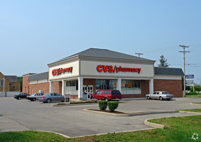
Property Record
900 N Broad St, Fairborn, OH 45324


Current Lease Availabilities
NEARBY LISTINGS FOR SALE OR LEASE
Property Detail
900 N Broad St
Dayton, OH
Trinity Corner Pud
A02-0001-0010-0-0057-00
TRINITY CORNER PUD LOT 7668 0.9888AC N CENTRAL AV
Commercialnec
Greene
X
Ohio
39057C0010D
7668
2024
0.99 AC
2024
East Dayton
200400
Cincinnati/Dayton
10,401 SF
DEMOGRAPHICS near 900 N Broad St
1 Mile
3 Mile
5 Mile
2024 Total Population
5,730
25,534
72,013
2029 Population
5,871
26,151
73,382
Pop Growth 2024-2029
+ 2.46%
+ 2.42%
+ 1.90%
Average Age
40
40
39
2024 Total Households
2,576
11,164
30,495
HH Growth 2024-2029
+ 2.41%
+ 2.43%
+ 2.13%
Median Household Inc
$56,688
$59,720
$66,622
Avg Household Size
2.20
2.20
2.30
2024 Avg HH Vehicles
2.00
2.00
2.00
Median Home Value
$101,770
$136,891
$168,599
Median Year Built
1951
1960
1975
Nearby Places
Map Layers
Map Styles
 Street
 Aerial
- Restaurants
- Banks
- Shops
- Fitness
- Groceries
PUBLIC TRANSPORTATION
AIRPORT
James M Cox Dayton International
DRIVE
WALK
Distance
James M Cox Dayton International
25 min
16.7 mi
Nearby Properties
Address
Land Use
TOTAL SIZE
Lot Size
Zoning
Address
Land Use
TOTAL SIZE
Lot Size
Zoning
101,768 SF
22.02 AC
B1
Address
Land Use
TOTAL SIZE
Lot Size
Zoning
21,740 SF
16.48 AC
Address
Land Use
TOTAL SIZE
Lot Size
Zoning
46,802 SF
25.30 AC
R3
Address
Land Use
TOTAL SIZE
Lot Size
Zoning
4,494 SF
23.15 AC
R1
Address
Land Use
TOTAL SIZE
Lot Size
Zoning
7,772 SF
8.52 AC
R3
Address
Land Use
TOTAL SIZE
Lot Size
Zoning
14,496 SF
0.64 AC
2
Address
Land Use
TOTAL SIZE
Lot Size
Zoning
261,152 SF
15.63 AC
B3
Address
Land Use
TOTAL SIZE
Lot Size
Zoning
24,522 SF
8.46 AC
R3
Address
Land Use
TOTAL SIZE
Lot Size
Zoning
42,733 SF
66.92 AC
Address
Land Use
TOTAL SIZE
Lot Size
Zoning
38,324 SF
2.77 AC
R4
Address
Land Use
TOTAL SIZE
Lot Size
Zoning
31,338 SF
0.25 AC
B2
Address
Land Use
TOTAL SIZE
Lot Size
Zoning
2,556 SF
338.34 AC
Address
Land Use
TOTAL SIZE
Lot Size
Zoning
11,176 SF
9.03 AC
Address
Land Use
TOTAL SIZE
Lot Size
Zoning
11,631 SF
2.44 AC
B3
Address
Land Use
TOTAL SIZE
Lot Size
Zoning
121,316 SF
20.43 AC
AG
Address
Land Use
TOTAL SIZE
Lot Size
Zoning
48,228 SF
1.60 AC
R4
Address
Land Use
TOTAL SIZE
Lot Size
Zoning
31,907 SF
10.96 AC
Address
Land Use
TOTAL SIZE
Lot Size
Zoning
79,032 SF
15.40 AC
IR
Address
Land Use
TOTAL SIZE
Lot Size
Zoning
27,500 SF
18.01 AC
I2
Address
Land Use
TOTAL SIZE
Lot Size
Zoning
17,822 SF
1.88 AC
R1
Address
Land Use
TOTAL SIZE
Lot Size
Zoning
94,317 SF
4.12 AC
PD1
Address
Land Use
TOTAL SIZE
Lot Size
Zoning
14,038 SF
4.88 AC
Address
Land Use
TOTAL SIZE
Lot Size
Zoning
1,358 SF
2.88 AC
R1
Address
Land Use
TOTAL SIZE
Lot Size
Zoning
91,172 SF
18.11 AC
B3
Address
Land Use
TOTAL SIZE
Lot Size
Zoning
56,470 SF
9.84 AC
Address
Land Use
TOTAL SIZE
Lot Size
Zoning
26,283 SF
15.37 AC
PARK
Address
Land Use
TOTAL SIZE
Lot Size
Zoning
31,528 SF
3.95 AC
B3
Address
Land Use
TOTAL SIZE
Lot Size
Zoning
31,910 SF
7.40 AC
IR
Address
Land Use
TOTAL SIZE
Lot Size
Zoning
Address
Land Use
TOTAL SIZE
Lot Size
Zoning
7,310 SF
3 AC
R-1
The World's #1 Commercial Real Estate Marketplace
Connect with us
© 2025 CoStar Group
The information above has been obtained from sources believed reliable. While we do not doubt its accuracy we have not verified it and make no guarantee, warranty or representation about it. It is your responsibility to independently confirm its accuracy and completeness. Any projections, opinions, assumptions, or estimates used are for example only and do not represent the current or future performance of the property. The value of this transaction to you depends on tax and other factors which should be evaluated by your tax, financial, and legal advisors. You and your advisors should conduct a careful, independent investigation of the property to determine to your satisfaction the suitability of the property for your needs.