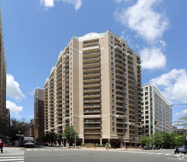
Property Record
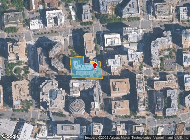
900 N Randolph St, Arlington, VA 22203

NEARBY LISTINGS FOR SALE OR LEASE
Property Detail
900 N Randolph St
Washington-Arlington-Alexandria, DC-VA-MD-WV
Ballston
14-046-029
PARCEL A RICHMOD SQUARE RESUB PARC 1A JEFF SQ LTS 7 8 PT 9 & VAC ALLEY BK 6 CENTER BALLSTON 52,135 SQ FT 1.19685 AC
Apartment
Arlington
X
Virginia
51013C0038D
7
2025
1.20 AC
2025
Ballston/Virginia Square
101407
Washington, DC
996,000 SF
DEMOGRAPHICS near 900 N Randolph St
1 Mile
3 Mile
5 Mile
2024 Total Population
44,654
251,462
615,385
2029 Population
44,112
247,562
593,415
Pop Growth 2024-2029
(1.21%)
(1.55%)
(3.57%)
Average Age
37
38
38
2024 Total Households
21,878
109,849
280,309
HH Growth 2024-2029
(1.28%)
(1.60%)
(4.28%)
Median Household Inc
$139,215
$119,195
$119,647
Avg Household Size
2.00
2.20
2.10
2024 Avg HH Vehicles
1.00
1.00
1.00
Median Home Value
$786,759
$760,516
$777,786
Median Year Built
1991
1974
1967
Nearby Places
Map Layers
Map Styles
 Street
 Aerial
- Restaurants
- Banks
- Shops
- Fitness
- Groceries
PUBLIC TRANSPORTATION
TRANSIT/SUBWAY
Ballston-Mu (Orange Line - Washington Metropolitan Area Transit Authority Metrorail (Metrorail), Silver Line - Washington Metropolitan Area Transit Authority Metrorail (Metrorail))
DRIVE
WALK
Distance
Ballston-Mu (Orange Line - Washington Metropolitan Area Transit Authority Metrorail (Metrorail), Silver Line - Washington Metropolitan Area Transit Authority Metrorail (Metrorail))
0 min
3 min
0.2 mi
Virginia Square-Gmu (Orange Line - Washington Metropolitan Area Transit Authority Metrorail (Metrorail), Silver Line - Washington Metropolitan Area Transit Authority Metrorail (Metrorail))
DRIVE
WALK
Distance
Virginia Square-Gmu (Orange Line - Washington Metropolitan Area Transit Authority Metrorail (Metrorail), Silver Line - Washington Metropolitan Area Transit Authority Metrorail (Metrorail))
1 min
7 min
0.4 mi
Clarendon (Orange Line - Washington Metropolitan Area Transit Authority Metrorail (Metrorail), Silver Line - Washington Metropolitan Area Transit Authority Metrorail (Metrorail))
DRIVE
WALK
Distance
Clarendon (Orange Line - Washington Metropolitan Area Transit Authority Metrorail (Metrorail), Silver Line - Washington Metropolitan Area Transit Authority Metrorail (Metrorail))
2 min
17 min
0.9 mi
COMMUTER RAIL
Crystal City (Fredericksburg Line - Virginia Railway Express, Manassas Line - Virginia Railway Express)
DRIVE
WALK
Distance
Crystal City (Fredericksburg Line - Virginia Railway Express, Manassas Line - Virginia Railway Express)
10 min
4.7 mi
4 (Fredericksburg Line - Virginia Railway Express, Manassas Line - Virginia Railway Express)
DRIVE
WALK
Distance
4 (Fredericksburg Line - Virginia Railway Express, Manassas Line - Virginia Railway Express)
12 min
5.6 mi
AIRPORT
Ronald Reagan Washington Ntl
DRIVE
WALK
Distance
Ronald Reagan Washington Ntl
14 min
6.0 mi
Washington Dulles International
DRIVE
WALK
Distance
Washington Dulles International
36 min
22.1 mi
Freight Ports
Port of Baltimore
DRIVE
WALK
Distance
Port of Baltimore
66 min
44.5 mi
SALE & LEASE HISTORY
LISTING DATE
SALE/LEASE

Jun 02, 2023
For Lease
Nearby Properties
Address
Land Use
TOTAL SIZE
Lot Size
Zoning
Address
Land Use
TOTAL SIZE
Lot Size
Zoning
6,500,000 SF
92.03 AC
S-3A
Address
Land Use
TOTAL SIZE
Lot Size
Zoning
900,000 SF
260 AC
S-3A
Address
Land Use
TOTAL SIZE
Lot Size
Zoning
77.26 AC
R-3/GT
Address
Land Use
TOTAL SIZE
Lot Size
Zoning
636,768 SF
1.91 AC
C-O-ROSSLY
Address
Land Use
TOTAL SIZE
Lot Size
Zoning
508,547 SF
4.58 AC
C-O-2.5
Address
Land Use
TOTAL SIZE
Lot Size
Zoning
293,674 SF
13.45 AC
C-O-2.5
Address
Land Use
TOTAL SIZE
Lot Size
Zoning
20.19 AC
S-3A/S-D
Address
Land Use
TOTAL SIZE
Lot Size
Zoning
45,523 SF
0.24 AC
C-O-ROSSLY
Address
Land Use
TOTAL SIZE
Lot Size
Zoning
62,298 SF
2.58 AC
R-5
Address
Land Use
TOTAL SIZE
Lot Size
Zoning
1,882 SF
0.97 AC
C-O-A
Address
Land Use
TOTAL SIZE
Lot Size
Zoning
580,759 SF
0.69 AC
C-O/C-O-RO
Address
Land Use
TOTAL SIZE
Lot Size
Zoning
633,810 SF
3.45 AC
RA-H-3.2
Address
Land Use
TOTAL SIZE
Lot Size
Zoning
591,243 SF
1.90 AC
RA-H-3.2
Address
Land Use
TOTAL SIZE
Lot Size
Zoning
986,000 SF
2.30 AC
C-O-A
Address
Land Use
TOTAL SIZE
Lot Size
Zoning
597,364 SF
1.66 AC
C-O/C-O-2.
Address
Land Use
TOTAL SIZE
Lot Size
Zoning
224,700 SF
1.30 AC
C-O-2.5
Address
Land Use
TOTAL SIZE
Lot Size
Zoning
12,786 SF
2.19 AC
C-2
Address
Land Use
TOTAL SIZE
Lot Size
Zoning
354,000 SF
0.67 AC
C-O-ROSSLY
Address
Land Use
TOTAL SIZE
Lot Size
Zoning
924,015 SF
89.81 AC
S-3A
Address
Land Use
TOTAL SIZE
Lot Size
Zoning
523,155 SF
1.76 AC
RA-H-3.2
Address
Land Use
TOTAL SIZE
Lot Size
Zoning
0.94 AC
C-O-2.5
Address
Land Use
TOTAL SIZE
Lot Size
Zoning
436 SF
75 AC
UNZONED
Address
Land Use
TOTAL SIZE
Lot Size
Zoning
9,800 SF
1.40 AC
C-O-A
Address
Land Use
TOTAL SIZE
Lot Size
Zoning
727,145 SF
19.72 AC
S-3A
Address
Land Use
TOTAL SIZE
Lot Size
Zoning
528 SF
296.59 AC
MU-11;MU-1
Address
Land Use
TOTAL SIZE
Lot Size
Zoning
12,635 SF
1.75 AC
RA4.8
Address
Land Use
TOTAL SIZE
Lot Size
Zoning
1,600 SF
1.92 AC
RA6-15/RC
The World's #1 Commercial Real Estate Marketplace
Connect with us
© 2026 CoStar Group
The information above has been obtained from sources believed reliable. While we do not doubt its accuracy we have not verified it and make no guarantee, warranty or representation about it. It is your responsibility to independently confirm its accuracy and completeness. Any projections, opinions, assumptions, or estimates used are for example only and do not represent the current or future performance of the property. The value of this transaction to you depends on tax and other factors which should be evaluated by your tax, financial, and legal advisors. You and your advisors should conduct a careful, independent investigation of the property to determine to your satisfaction the suitability of the property for your needs.