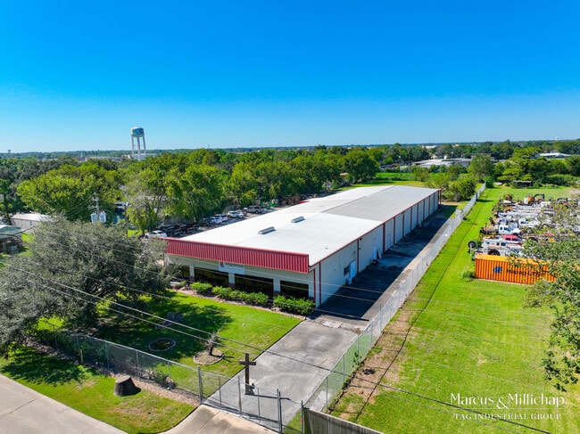
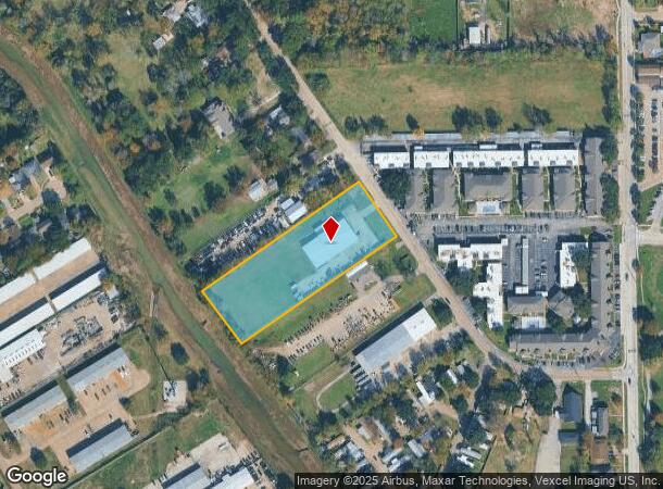
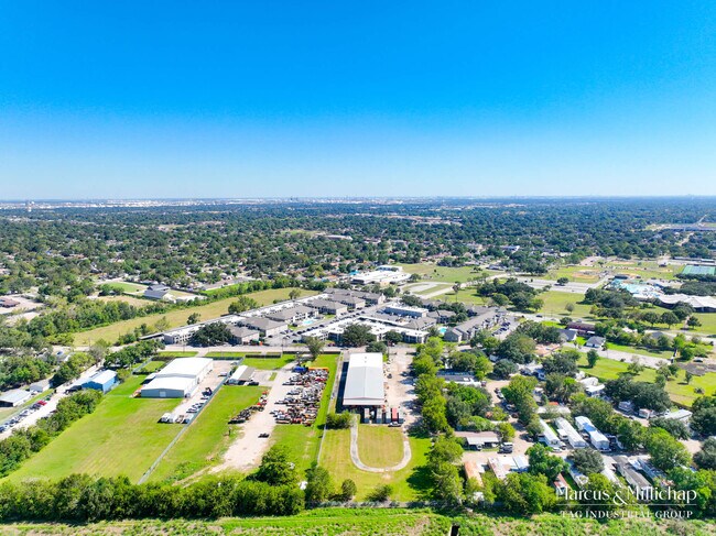
Property Record
900 Perla Rd, Pasadena, TX 77502
NEARBY LISTINGS FOR SALE OR LEASE
Property Detail
900 Perla Rd
0610860000229
Alta Vista Acres
Warehouse
TR 69B ALTA VISTA ACRES
AE
Harris
48201C0915N
Texas
2024
2.81 AC
2025
East-Southeast Far
323500
Houston
12,960 SF
Houston-Pasadena-The Woodlands, TX
DEMOGRAPHICS near 900 Perla Rd
1 Mile
3 Mile
5 Mile
2024 Total Population
21,196
157,514
289,456
2029 Population
21,465
160,311
294,550
Pop Growth 2024-2029
+ 1.27%
+ 1.78%
+ 1.76%
Average Age
34
35
36
2024 Total Households
6,470
50,027
95,645
HH Growth 2024-2029
+ 1.17%
+ 1.67%
+ 1.69%
Median Household Inc
$46,457
$50,990
$53,690
Avg Household Size
3.20
3.10
2.90
2024 Avg HH Vehicles
2.00
2.00
2.00
Median Home Value
$143,707
$146,308
$158,756
Median Year Built
1966
1970
1974
Nearby Places
Map Layers
Map Styles
 Street
 Aerial
- Restaurants
- Banks
- Shops
- Fitness
- Groceries
PUBLIC TRANSPORTATION
AIRPORT
William P Hobby
DRIVE
WALK
Distance
William P Hobby
19 min
7.9 mi
George Bush Intcntl/Houston
DRIVE
WALK
Distance
George Bush Intcntl/Houston
43 min
33.3 mi
Freight Ports
Port of Houston
DRIVE
WALK
Distance
Port of Houston
19 min
8.8 mi
SALE & LEASE HISTORY
LISTING DATE
SALE/LEASE

Oct 28, 2024
For Sale
Nearby Properties
Address
Land Use
TOTAL SIZE
Lot Size
Zoning
Address
Land Use
TOTAL SIZE
Lot Size
Zoning
552,961 SF
25.01 AC
Address
Land Use
TOTAL SIZE
Lot Size
Zoning
345,420 SF
4.02 AC
Address
Land Use
TOTAL SIZE
Lot Size
Zoning
414,017 SF
19.28 AC
Address
Land Use
TOTAL SIZE
Lot Size
Zoning
218,787 SF
10 AC
Address
Land Use
TOTAL SIZE
Lot Size
Zoning
281,470 SF
11.24 AC
Address
Land Use
TOTAL SIZE
Lot Size
Zoning
397,739 SF
15.93 AC
Address
Land Use
TOTAL SIZE
Lot Size
Zoning
504,938 SF
28.96 AC
Address
Land Use
TOTAL SIZE
Lot Size
Zoning
363,740 SF
16.92 AC
Address
Land Use
TOTAL SIZE
Lot Size
Zoning
342,149 SF
23.56 AC
Address
Land Use
TOTAL SIZE
Lot Size
Zoning
188,111 SF
31.13 AC
Address
Land Use
TOTAL SIZE
Lot Size
Zoning
563,016 SF
19.84 AC
Address
Land Use
TOTAL SIZE
Lot Size
Zoning
538,431 SF
21.31 AC
Address
Land Use
TOTAL SIZE
Lot Size
Zoning
157,845 SF
12.52 AC
Address
Land Use
TOTAL SIZE
Lot Size
Zoning
230,218 SF
10.67 AC
Address
Land Use
TOTAL SIZE
Lot Size
Zoning
219,143 SF
10.84 AC
Address
Land Use
TOTAL SIZE
Lot Size
Zoning
321,268 SF
9.59 AC
Address
Land Use
TOTAL SIZE
Lot Size
Zoning
Address
Land Use
TOTAL SIZE
Lot Size
Zoning
203,931 SF
25.06 AC
Address
Land Use
TOTAL SIZE
Lot Size
Zoning
446,728 SF
16.69 AC
Address
Land Use
TOTAL SIZE
Lot Size
Zoning
279,964 SF
11.87 AC
Address
Land Use
TOTAL SIZE
Lot Size
Zoning
155,316 SF
4.26 AC
Address
Land Use
TOTAL SIZE
Lot Size
Zoning
171,935 SF
11.83 AC
Address
Land Use
TOTAL SIZE
Lot Size
Zoning
132,777 SF
14.33 AC
Address
Land Use
TOTAL SIZE
Lot Size
Zoning
166,883 SF
7.71 AC
Address
Land Use
TOTAL SIZE
Lot Size
Zoning
178,312 SF
5.55 AC
Address
Land Use
TOTAL SIZE
Lot Size
Zoning
163,919 SF
5.99 AC
Address
Land Use
TOTAL SIZE
Lot Size
Zoning
225,304 SF
9.93 AC
Address
Land Use
TOTAL SIZE
Lot Size
Zoning
207,056 SF
15.79 AC
Address
Land Use
TOTAL SIZE
Lot Size
Zoning
269,086 SF
16.01 AC
Address
Land Use
TOTAL SIZE
Lot Size
Zoning
259,754 SF
12.35 AC
The World's #1 Commercial Real Estate Marketplace
Connect with us
© 2026 CoStar Group
The information above has been obtained from sources believed reliable. While we do not doubt its accuracy we have not verified it and make no guarantee, warranty or representation about it. It is your responsibility to independently confirm its accuracy and completeness. Any projections, opinions, assumptions, or estimates used are for example only and do not represent the current or future performance of the property. The value of this transaction to you depends on tax and other factors which should be evaluated by your tax, financial, and legal advisors. You and your advisors should conduct a careful, independent investigation of the property to determine to your satisfaction the suitability of the property for your needs.