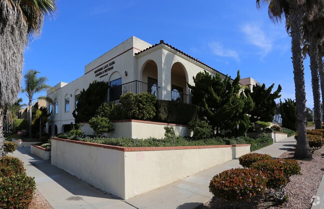
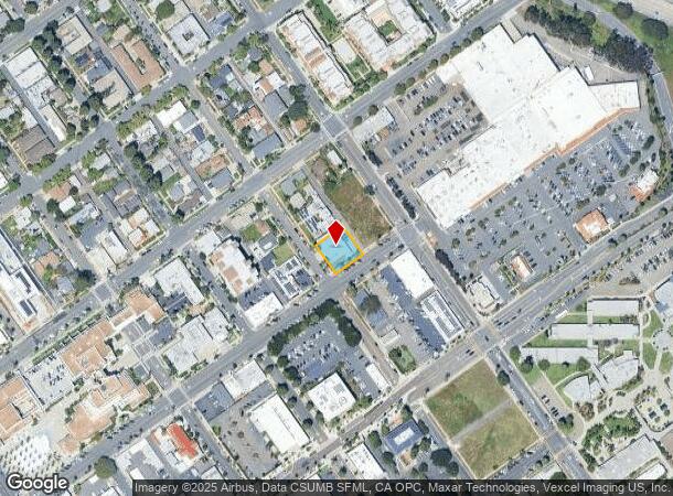
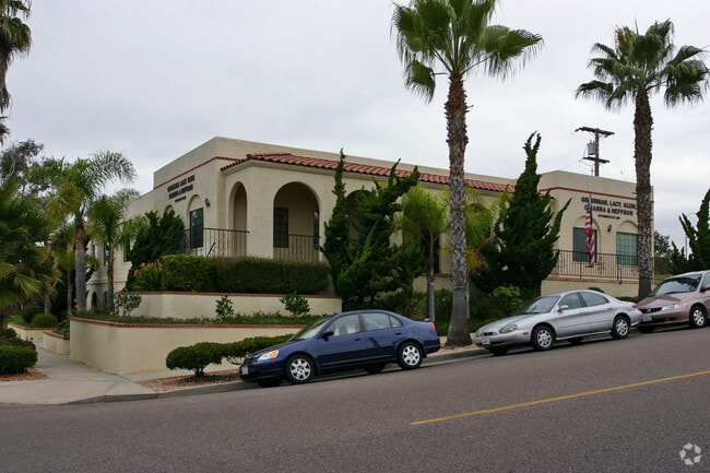
Property Record
900 Pier View Way, Oceanside, CA 92054

NEARBY LISTINGS FOR SALE OR LEASE
Property Detail
900 Pier View Way
San Diego-Carlsbad, CA
City Of Oceanside
147-107-15
LOT 1 TR PM15177
Storesoffices
San Diego
X
California
06073C0734J
1
2024
0.23 AC
2025
Oceanside
018400
San Diego
5,472 SF
DEMOGRAPHICS near 900 Pier View Way
1 Mile
3 Mile
5 Mile
2024 Total Population
20,568
70,400
157,242
2029 Population
20,798
70,679
156,950
Pop Growth 2024-2029
+ 1.12%
+ 0.40%
(0.19%)
Average Age
40
37
38
2024 Total Households
8,668
25,067
56,572
HH Growth 2024-2029
+ 1.67%
+ 0.70%
(0.08%)
Median Household Inc
$65,306
$70,674
$78,286
Avg Household Size
2.30
2.50
2.50
2024 Avg HH Vehicles
2.00
2.00
2.00
Median Home Value
$736,208
$769,786
$732,586
Median Year Built
1977
1977
1981
Nearby Places
Map Layers
Map Styles
 Street
 Aerial
- Restaurants
- Banks
- Shops
- Fitness
- Groceries
PUBLIC TRANSPORTATION
COMMUTER RAIL
Oceanside Transit Center (Orange County Line - Southern California Regional Rail Authority (Metrolink))
DRIVE
WALK
Distance
Oceanside Transit Center (Orange County Line - Southern California Regional Rail Authority (Metrolink))
3 min
15 min
0.8 mi
Carlsbad Village (Coaster - San Diego North County Transit District (Coaster/Sprinter/Breeze))
DRIVE
WALK
Distance
Carlsbad Village (Coaster - San Diego North County Transit District (Coaster/Sprinter/Breeze))
8 min
3.9 mi
AIRPORT
San Diego International
DRIVE
WALK
Distance
San Diego International
45 min
35.8 mi
John Wayne/Orange County
DRIVE
WALK
Distance
John Wayne/Orange County
59 min
49.3 mi
Freight Ports
Port of San Diego
DRIVE
WALK
Distance
Port of San Diego
51 min
40.3 mi
Nearby Properties
Address
Land Use
TOTAL SIZE
Lot Size
Zoning
Address
Land Use
TOTAL SIZE
Lot Size
Zoning
1.38 AC
C
Address
Land Use
TOTAL SIZE
Lot Size
Zoning
5.28 AC
C2
Address
Land Use
TOTAL SIZE
Lot Size
Zoning
1.38 AC
C
Address
Land Use
TOTAL SIZE
Lot Size
Zoning
1.14 AC
C
Address
Land Use
TOTAL SIZE
Lot Size
Zoning
85,000 SF
4.40 AC
CC
Address
Land Use
TOTAL SIZE
Lot Size
Zoning
19.51 AC
C-2-Q
Address
Land Use
TOTAL SIZE
Lot Size
Zoning
1.02 AC
D-1
Address
Land Use
TOTAL SIZE
Lot Size
Zoning
4.68 AC
D-6B
Address
Land Use
TOTAL SIZE
Lot Size
Zoning
64,722 SF
2.17 AC
D-1
Address
Land Use
TOTAL SIZE
Lot Size
Zoning
6,024 SF
6.92 AC
VC
Address
Land Use
TOTAL SIZE
Lot Size
Zoning
92,481 SF
9.53 AC
CG-PBD
Address
Land Use
TOTAL SIZE
Lot Size
Zoning
96,942 SF
4.49 AC
R-3
Address
Land Use
TOTAL SIZE
Lot Size
Zoning
66,816 SF
9.55 AC
RH
Address
Land Use
TOTAL SIZE
Lot Size
Zoning
9.52 AC
CS-HO
Address
Land Use
TOTAL SIZE
Lot Size
Zoning
16.32 AC
PD-3
Address
Land Use
TOTAL SIZE
Lot Size
Zoning
12.19 AC
CS-HO
Address
Land Use
TOTAL SIZE
Lot Size
Zoning
6.76 AC
RM-C
Address
Land Use
TOTAL SIZE
Lot Size
Zoning
10.29 AC
RM-B
Address
Land Use
TOTAL SIZE
Lot Size
Zoning
80,450 SF
2.71 AC
D-1
Address
Land Use
TOTAL SIZE
Lot Size
Zoning
54,168 SF
1.76 AC
R-3
Address
Land Use
TOTAL SIZE
Lot Size
Zoning
82,584 SF
4.14 AC
RM-C
Address
Land Use
TOTAL SIZE
Lot Size
Zoning
75,360 SF
6.41 AC
CC
Address
Land Use
TOTAL SIZE
Lot Size
Zoning
43,032 SF
1.48 AC
R-3
Address
Land Use
TOTAL SIZE
Lot Size
Zoning
68,113 SF
4.19 AC
CS-HO
Address
Land Use
TOTAL SIZE
Lot Size
Zoning
82,810 SF
7.92 AC
CC
Address
Land Use
TOTAL SIZE
Lot Size
Zoning
10.84 AC
CC
Address
Land Use
TOTAL SIZE
Lot Size
Zoning
61,300 SF
1.26 AC
D-6A
Address
Land Use
TOTAL SIZE
Lot Size
Zoning
8.26 AC
CS-HO
Address
Land Use
TOTAL SIZE
Lot Size
Zoning
76,638 SF
2.50 AC
RH
Address
Land Use
TOTAL SIZE
Lot Size
Zoning
2.37 AC
C-2
The World's #1 Commercial Real Estate Marketplace
Connect with us
© 2025 CoStar Group
The information above has been obtained from sources believed reliable. While we do not doubt its accuracy we have not verified it and make no guarantee, warranty or representation about it. It is your responsibility to independently confirm its accuracy and completeness. Any projections, opinions, assumptions, or estimates used are for example only and do not represent the current or future performance of the property. The value of this transaction to you depends on tax and other factors which should be evaluated by your tax, financial, and legal advisors. You and your advisors should conduct a careful, independent investigation of the property to determine to your satisfaction the suitability of the property for your needs.