Property Record
900 Radisson St, Green Bay, WI 54302


Save to a Folder
{{folder.Name}}
{{folder.ListingIds.length}} Properties
{{folder.ListingIds.length}} Property
Create a New Folder
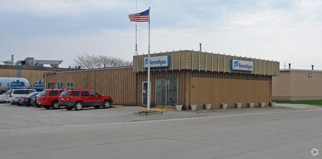
Property Detail
900 Radisson St
Green Bay, WI
2.696 AC M/L EASTMANS ADD LOTS 1 THRU 6 BLK 87 EX THE SLY 18 FT THEREOF & E1/2 VAC VAN BUREN ST ADJ ALSO LOTS 1 THRU 12 BLK 88 & W1/2 VAC VAN BUREN ST ADJ & E1/2 VAC N JACKSON ST ADJ & ALL OF VAC ALLEY ADJ
20-464
BROWN
Industrialgeneral
Wisconsin
B and X Area of moderate flood hazard, usually the area between the limits of the 100-year and 500-year floods.
1-6
2025
2.70 AC
2025
Green Bay
002001
Green Bay
NEARBY LISTINGS FOR SALE OR LEASE
DEMOGRAPHICS near 900 Radisson St
1 mile
3 mile
5 mile
2025 Total Population
5,016
63,921
132,352
2030 Population
5,032
64,754
134,642
Pop Growth 2025-2030
+ 0.32%
+ 1.30%
+ 1.73%
Average Age
35
38
39
2025 Total Households
1,876
26,815
55,646
HH Growth 2025-2030
+ 0.53%
+ 1.35%
+ 1.87%
Median Household Inc
$46,713
$57,603
$65,253
Avg Household Size
2.50
2.30
2.30
2025 Avg HH Vehicles
2.00
2.00
2.00
Median Home Value
$150,647
$168,649
$216,424
Median Year Built
1953
1959
1972
Nearby Places
Map Layers
Map Styles
 Street
 Aerial
Layers
 Traffic
 Biking
Places
Listings with unknown addresses are not visible on the map
- Restaurants
- Banks
- Shops
- Fitness
- Groceries
PUBLIC TRANSPORTATION
AIRPORT
Green Bay/Austin Straubel International
Drive
Walk
Distance
Green Bay/Austin Straubel International
18 min
9.9 mi
Freight Ports
Port Milwaukee
Drive
Walk
Distance
Port Milwaukee
134 min
118.7 mi
Nearby Properties
Address
Land Use
TOTAL SIZE
Lot Size
Zoning
Address
Land Use
TOTAL SIZE
Lot Size
Zoning
197.25 AC
Address
Land Use
TOTAL SIZE
Lot Size
Zoning
36.49 AC
Address
Land Use
TOTAL SIZE
Lot Size
Zoning
6.32 AC
R1
Address
Land Use
TOTAL SIZE
Lot Size
Zoning
3,368 SF
27.55 AC
C1, OR
Address
Land Use
TOTAL SIZE
Lot Size
Zoning
Address
Land Use
TOTAL SIZE
Lot Size
Zoning
96.49 AC
Address
Land Use
TOTAL SIZE
Lot Size
Zoning
Address
Land Use
TOTAL SIZE
Lot Size
Zoning
982 SF
34.29 AC
R1
Address
Land Use
TOTAL SIZE
Lot Size
Zoning
780 SF
0.16 AC
R1
Address
Land Use
TOTAL SIZE
Lot Size
Zoning
14.75 AC
Address
Land Use
TOTAL SIZE
Lot Size
Zoning
23.44 AC
Address
Land Use
TOTAL SIZE
Lot Size
Zoning
28.23 AC
Address
Land Use
TOTAL SIZE
Lot Size
Zoning
13.56 AC
C1, R3
Address
Land Use
TOTAL SIZE
Lot Size
Zoning
0.74 AC
Address
Land Use
TOTAL SIZE
Lot Size
Zoning
0.63 AC
Address
Land Use
TOTAL SIZE
Lot Size
Zoning
1.25 AC
Address
Land Use
TOTAL SIZE
Lot Size
Zoning
15.43 AC
Address
Land Use
TOTAL SIZE
Lot Size
Zoning
28.20 AC
Address
Land Use
TOTAL SIZE
Lot Size
Zoning
25.53 AC
Address
Land Use
TOTAL SIZE
Lot Size
Zoning
39,614 SF
2.40 AC
CON, LI
Address
Land Use
TOTAL SIZE
Lot Size
Zoning
1,782 SF
6.32 AC
R1
Address
Land Use
TOTAL SIZE
Lot Size
Zoning
0.48 AC
Address
Land Use
TOTAL SIZE
Lot Size
Zoning
81,981 SF
0.80 AC
D2
Address
Land Use
TOTAL SIZE
Lot Size
Zoning
567,424 SF
53.92 AC
C1, GI
Address
Land Use
TOTAL SIZE
Lot Size
Zoning
320,146 SF
48.50 AC
GI, R1
Address
Land Use
TOTAL SIZE
Lot Size
Zoning
0.71 AC
Address
Land Use
TOTAL SIZE
Lot Size
Zoning
418,272 SF
31.74 AC
GI
Address
Land Use
TOTAL SIZE
Lot Size
Zoning
268,880 SF
23.35 AC
GI
Address
Land Use
TOTAL SIZE
Lot Size
Zoning
Address
Land Use
TOTAL SIZE
Lot Size
Zoning
936 SF
3.09 AC
R1
The World's #1 Commercial Real Estate Marketplace
Connect with us
© 2026 CoStar Group
The information above has been obtained from sources believed reliable. While we do not doubt its accuracy we have not verified it and make no guarantee, warranty or representation about it. It is your responsibility to independently confirm its accuracy and completeness. Any projections, opinions, assumptions, or estimates used are for example only and do not represent the current or future performance of the property. The value of this transaction to you depends on tax and other factors which should be evaluated by your tax, financial, and legal advisors. You and your advisors should conduct a careful, independent investigation of the property to determine to your satisfaction the suitability of the property for your needs.