Property Record
900 S Main St, Eaton Rapids, MI 48827
NEARBY LISTINGS FOR SALE OR LEASE
-
-
View all Eaton Rapids listings for sale on LoopNet.com
Property Detail
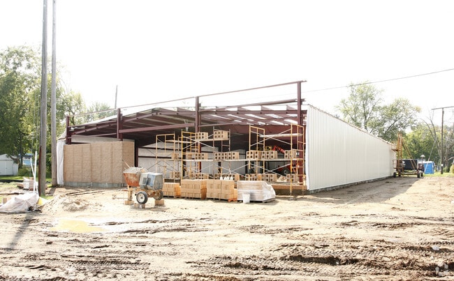
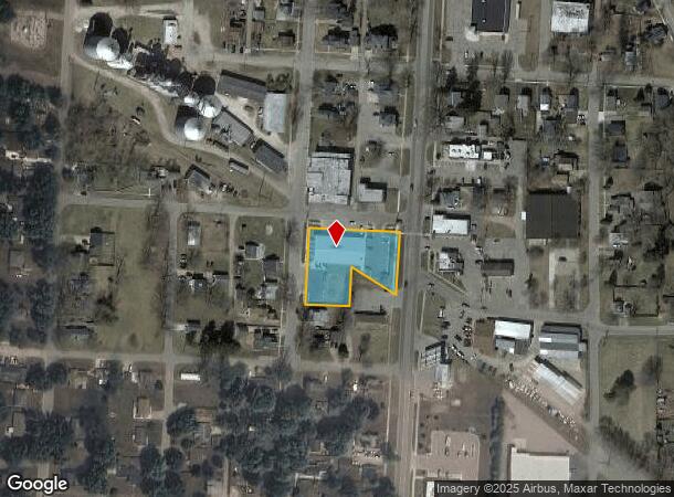
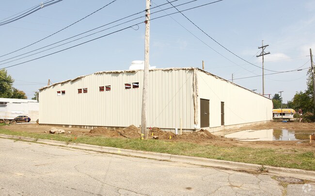
900 S Main St
Lansing-East Lansing, MI
Mrs Waldrons Add
300-086-642-010-01
LOTS 1,2,3,4,5 & 6, EXCEPT COM AT SE COR LOT 5, W TO SW COR LOT 5, N 104 FT, SELY 119 FT TO A PT 38 FT N OF SE COR LOT 5, S 38 FT TO BEG. W 8.25 FT OF VACATED ALLEY ADJACENT TO LOTS 2,3 & 6. E 8.25 FT OF N 94 FT OF VACATED ALLEY ADJACENT TO LOTS 1 &
Wholesaleoutletdiscountstore
Eaton
X
Michigan
26045C0343E
1-6
2024
0.89 AC
2025
Outlying Eaton County
021302
West Michigan
8,955 SF
DEMOGRAPHICS near 900 S Main St
1 Mile
3 Mile
5 Mile
2024 Total Population
4,988
8,850
12,799
2029 Population
5,018
8,871
12,785
Pop Growth 2024-2029
+ 0.60%
+ 0.24%
(0.11%)
Average Age
41
42
42
2024 Total Households
2,083
3,594
5,090
HH Growth 2024-2029
+ 0.67%
+ 0.31%
(0.08%)
Median Household Inc
$50,852
$60,519
$67,676
Avg Household Size
2.30
2.40
2.50
2024 Avg HH Vehicles
2.00
2.00
2.00
Median Home Value
$157,731
$184,824
$205,495
Median Year Built
1963
1969
1973
Nearby Places
Map Layers
Map Styles
 Street
 Aerial
- Restaurants
- Banks
- Shops
- Fitness
- Groceries
PUBLIC TRANSPORTATION
AIRPORT
Capital Region International
DRIVE
WALK
Distance
Capital Region International
36 min
20.7 mi
Nearby Properties
Address
Land Use
TOTAL SIZE
Lot Size
Zoning
Address
Land Use
TOTAL SIZE
Lot Size
Zoning
54,168 SF
2.22 AC
MFRD
Address
Land Use
TOTAL SIZE
Lot Size
Zoning
182,227 SF
15.57 AC
GID
Address
Land Use
TOTAL SIZE
Lot Size
Zoning
49,443 SF
5.21 AC
GID
Address
Land Use
TOTAL SIZE
Lot Size
Zoning
16,600 SF
2.09 AC
MFRD
Address
Land Use
TOTAL SIZE
Lot Size
Zoning
142,559 SF
3.07 AC
MFRD
Address
Land Use
TOTAL SIZE
Lot Size
Zoning
49,834 SF
5.80 AC
MFRD
Address
Land Use
TOTAL SIZE
Lot Size
Zoning
43,924 SF
4.26 AC
GID
Address
Land Use
TOTAL SIZE
Lot Size
Zoning
48,184 SF
2.95 AC
GBD
Address
Land Use
TOTAL SIZE
Lot Size
Zoning
92,931 SF
19.34 AC
GID
Address
Land Use
TOTAL SIZE
Lot Size
Zoning
65,181 SF
6.18 AC
GID
Address
Land Use
TOTAL SIZE
Lot Size
Zoning
732 SF
38.14 AC
Address
Land Use
TOTAL SIZE
Lot Size
Zoning
71,133 SF
7.34 AC
GID
Address
Land Use
TOTAL SIZE
Lot Size
Zoning
80,488 SF
5.05 AC
GID
Address
Land Use
TOTAL SIZE
Lot Size
Zoning
34,584 SF
1.90 AC
MFRD
Address
Land Use
TOTAL SIZE
Lot Size
Zoning
55,280 SF
4.71 AC
GID
Address
Land Use
TOTAL SIZE
Lot Size
Zoning
3,835 SF
1.79 AC
GBD
Address
Land Use
TOTAL SIZE
Lot Size
Zoning
48,034 SF
1.65 AC
MFRD
Address
Land Use
TOTAL SIZE
Lot Size
Zoning
34,380 SF
4.68 AC
GID
Address
Land Use
TOTAL SIZE
Lot Size
Zoning
257.20 AC
LA
Address
Land Use
TOTAL SIZE
Lot Size
Zoning
46,617 SF
2.07 AC
GID
Address
Land Use
TOTAL SIZE
Lot Size
Zoning
8,870 SF
14.45 AC
C2
Address
Land Use
TOTAL SIZE
Lot Size
Zoning
3,156 SF
158.72 AC
LA
Address
Land Use
TOTAL SIZE
Lot Size
Zoning
3,156 SF
158.72 AC
LA
Address
Land Use
TOTAL SIZE
Lot Size
Zoning
11,342 SF
2.64 AC
GBD
Address
Land Use
TOTAL SIZE
Lot Size
Zoning
36,380 SF
9 AC
GID
Address
Land Use
TOTAL SIZE
Lot Size
Zoning
10,895 SF
1.24 AC
GBD
Address
Land Use
TOTAL SIZE
Lot Size
Zoning
37,024 SF
1.50 AC
MFRD
Address
Land Use
TOTAL SIZE
Lot Size
Zoning
41,223 SF
7.44 AC
RD1
Address
Land Use
TOTAL SIZE
Lot Size
Zoning
29,930 SF
4 AC
GID
Address
Land Use
TOTAL SIZE
Lot Size
Zoning
6,912 SF
0.85 AC
GBD
The World's #1 Commercial Real Estate Marketplace
Connect with us
© 2025 CoStar Group
The information above has been obtained from sources believed reliable. While we do not doubt its accuracy we have not verified it and make no guarantee, warranty or representation about it. It is your responsibility to independently confirm its accuracy and completeness. Any projections, opinions, assumptions, or estimates used are for example only and do not represent the current or future performance of the property. The value of this transaction to you depends on tax and other factors which should be evaluated by your tax, financial, and legal advisors. You and your advisors should conduct a careful, independent investigation of the property to determine to your satisfaction the suitability of the property for your needs.