Property Record
900 View Dr, Woodstock, GA 30189
NEARBY LISTINGS FOR SALE OR LEASE
-
-
View all Woodstock listings for sale on LoopNet.com
Property Detail
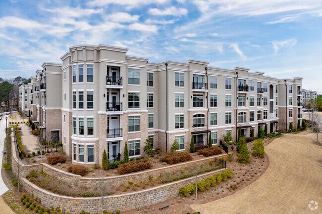
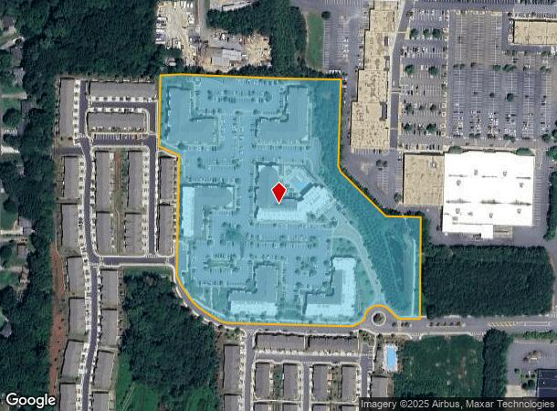
900 View Dr
015N12-00000-017-00A-0000
LL 1231 15TH D
Apartment
Cherokee
X
Georgia
13057C0327E
14.60 AC
2025
Cherokee County
2025
Atlanta
091013
Atlanta-Sandy Springs-Roswell, GA
197,890 SF
DEMOGRAPHICS near 900 View Dr
1 Mile
3 Mile
5 Mile
2024 Total Population
7,021
75,093
188,042
2029 Population
7,966
82,536
203,738
Pop Growth 2024-2029
+ 13.46%
+ 9.91%
+ 8.35%
Average Age
40
39
39
2024 Total Households
2,686
28,111
68,760
HH Growth 2024-2029
+ 13.96%
+ 10.28%
+ 8.56%
Median Household Inc
$92,762
$88,052
$92,862
Avg Household Size
2.60
2.60
2.60
2024 Avg HH Vehicles
2.00
2.00
2.00
Median Home Value
$275,714
$302,164
$313,300
Median Year Built
1991
1992
1993
Nearby Places
Map Layers
Map Styles
 Street
 Aerial
- Restaurants
- Banks
- Shops
- Fitness
- Groceries
PUBLIC TRANSPORTATION
AIRPORT
Hartsfield - Jackson Atlanta International
DRIVE
WALK
Distance
Hartsfield - Jackson Atlanta International
51 min
38.1 mi
Nearby Properties
Address
Land Use
TOTAL SIZE
Lot Size
Zoning
Address
Land Use
TOTAL SIZE
Lot Size
Zoning
523,803 SF
148.37 AC
R-40
Address
Land Use
TOTAL SIZE
Lot Size
Zoning
56,439 SF
13.69 AC
GC
Address
Land Use
TOTAL SIZE
Lot Size
Zoning
189,621 SF
12.16 AC
R-40
Address
Land Use
TOTAL SIZE
Lot Size
Zoning
228,644 SF
7.88 AC
DT-CBD
Address
Land Use
TOTAL SIZE
Lot Size
Zoning
309,011 SF
64.20 AC
PUD
Address
Land Use
TOTAL SIZE
Lot Size
Zoning
175,587 SF
17.71 AC
RTH
Address
Land Use
TOTAL SIZE
Lot Size
Zoning
181,704 SF
17.56 AC
DT-MRA
Address
Land Use
TOTAL SIZE
Lot Size
Zoning
399,085 SF
38.48 AC
LI
Address
Land Use
TOTAL SIZE
Lot Size
Zoning
188,105 SF
25.86 AC
R-5
Address
Land Use
TOTAL SIZE
Lot Size
Zoning
201,331 SF
15.48 AC
RM16
Address
Land Use
TOTAL SIZE
Lot Size
Zoning
346,900 SF
104.10 AC
CD
Address
Land Use
TOTAL SIZE
Lot Size
Zoning
360,937 SF
32.56 AC
RM-12
Address
Land Use
TOTAL SIZE
Lot Size
Zoning
235,861 SF
31.92 AC
RM10
Address
Land Use
TOTAL SIZE
Lot Size
Zoning
238,600 SF
21.10 AC
R-3
Address
Land Use
TOTAL SIZE
Lot Size
Zoning
91,547 SF
18.48 AC
R-3
Address
Land Use
TOTAL SIZE
Lot Size
Zoning
195,033 SF
22.85 AC
RM-8
Address
Land Use
TOTAL SIZE
Lot Size
Zoning
255,460 SF
20.28 AC
RM16
Address
Land Use
TOTAL SIZE
Lot Size
Zoning
232,415 SF
19.23 AC
RM-12
Address
Land Use
TOTAL SIZE
Lot Size
Zoning
189,456 SF
28.35 AC
NC-TCT
Address
Land Use
TOTAL SIZE
Lot Size
Zoning
229,440 SF
13 AC
OI
Address
Land Use
TOTAL SIZE
Lot Size
Zoning
113,849 SF
7.46 AC
R-5
Address
Land Use
TOTAL SIZE
Lot Size
Zoning
186,426 SF
32.52 AC
NC-TCT
Address
Land Use
TOTAL SIZE
Lot Size
Zoning
85,166 SF
3.41 AC
DT-CBD
Address
Land Use
TOTAL SIZE
Lot Size
Zoning
85,671 SF
12.25 AC
RM10
Address
Land Use
TOTAL SIZE
Lot Size
Zoning
194,729 SF
29.67 AC
GC
Address
Land Use
TOTAL SIZE
Lot Size
Zoning
134,017 SF
32.51 AC
AG
Address
Land Use
TOTAL SIZE
Lot Size
Zoning
63,264 SF
8 AC
PUD
Address
Land Use
TOTAL SIZE
Lot Size
Zoning
132,022 SF
12.69 AC
GC
Address
Land Use
TOTAL SIZE
Lot Size
Zoning
5.46 AC
RSL
The World's #1 Commercial Real Estate Marketplace
Connect with us
© 2025 CoStar Group
The information above has been obtained from sources believed reliable. While we do not doubt its accuracy we have not verified it and make no guarantee, warranty or representation about it. It is your responsibility to independently confirm its accuracy and completeness. Any projections, opinions, assumptions, or estimates used are for example only and do not represent the current or future performance of the property. The value of this transaction to you depends on tax and other factors which should be evaluated by your tax, financial, and legal advisors. You and your advisors should conduct a careful, independent investigation of the property to determine to your satisfaction the suitability of the property for your needs.