Property Record
900 W Lincoln Hwy, Langhorne, PA 19047

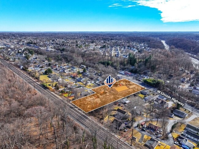
This Property Is For Sale
NEARBY LISTINGS FOR SALE OR LEASE
Property Detail
900 W Lincoln Hwy
Philadelphia
Parkland Plan
Philadelphia-Camden-Wilmington, PA-NJ-DE-MD
PO LOT #1 SEC #1 PARKLAND PLAN 25X50
22-019-059
Bucks
Storageyardjunkautowreckingsalvage
Pennsylvania
2024
1
2025
0.03 AC
100900
Lower Bucks County
DEMOGRAPHICS near 900 W Lincoln Hwy
1 Mile
3 Mile
5 Mile
2024 Total Population
12,440
79,363
233,254
2029 Population
12,419
78,852
230,874
Pop Growth 2024-2029
(0.17%)
(0.64%)
(1.02%)
Average Age
42
43
43
2024 Total Households
4,670
29,787
88,052
HH Growth 2024-2029
(0.19%)
(0.74%)
(1.15%)
Median Household Inc
$99,029
$96,298
$91,073
Avg Household Size
2.50
2.60
2.60
2024 Avg HH Vehicles
2.00
2.00
2.00
Median Home Value
$323,679
$343,127
$325,599
Median Year Built
1974
1974
1971
Nearby Places
Map Layers
Map Styles
 Street
 Aerial
- Restaurants
- Banks
- Shops
- Fitness
- Groceries
PUBLIC TRANSPORTATION
TRANSIT/SUBWAY
Langhorne (R3 - Southeastern Pennsylvania Transportation Authority Regional Rail (SEPTA Regional Rail))
DRIVE
WALK
Distance
Langhorne (R3 - Southeastern Pennsylvania Transportation Authority Regional Rail (SEPTA Regional Rail))
3 min
19 min
1.0 mi
COMMUTER RAIL
Langhorne (R3 - Southeastern Pennsylvania Transportation Authority Regional Rail (SEPTA Regional Rail))
DRIVE
WALK
Distance
Langhorne (R3 - Southeastern Pennsylvania Transportation Authority Regional Rail (SEPTA Regional Rail))
3 min
1.1 mi
Neshaminy Falls (R3 - Southeastern Pennsylvania Transportation Authority Regional Rail (SEPTA Regional Rail))
DRIVE
WALK
Distance
Neshaminy Falls (R3 - Southeastern Pennsylvania Transportation Authority Regional Rail (SEPTA Regional Rail))
6 min
2.7 mi
AIRPORT
Trenton Mercer
DRIVE
WALK
Distance
Trenton Mercer
22 min
13.0 mi
Philadelphia International
DRIVE
WALK
Distance
Philadelphia International
50 min
32.2 mi
Freight Ports
Port of Philadelphia
DRIVE
WALK
Distance
Port of Philadelphia
30 min
18.5 mi
Nearby Properties
Address
Land Use
TOTAL SIZE
Lot Size
Zoning
Address
Land Use
TOTAL SIZE
Lot Size
Zoning
32,912 SF
42.06 AC
AO
Address
Land Use
TOTAL SIZE
Lot Size
Zoning
759,617 SF
23.82 AC
HC
Address
Land Use
TOTAL SIZE
Lot Size
Zoning
116,591 SF
2.65 AC
MI
Address
Land Use
TOTAL SIZE
Lot Size
Zoning
10,025 SF
19.11 AC
CD
Address
Land Use
TOTAL SIZE
Lot Size
Zoning
19.95 AC
CD
Address
Land Use
TOTAL SIZE
Lot Size
Zoning
202,400 SF
20.98 AC
C
Address
Land Use
TOTAL SIZE
Lot Size
Zoning
72,540 SF
14.02 AC
CD
Address
Land Use
TOTAL SIZE
Lot Size
Zoning
3,490 SF
15.80 AC
R1
Address
Land Use
TOTAL SIZE
Lot Size
Zoning
171,918 SF
17.70 AC
AO
Address
Land Use
TOTAL SIZE
Lot Size
Zoning
206,720 SF
0.97 AC
C
Address
Land Use
TOTAL SIZE
Lot Size
Zoning
163,779 SF
20.10 AC
MI
Address
Land Use
TOTAL SIZE
Lot Size
Zoning
41,546 SF
11.67 AC
CD
Address
Land Use
TOTAL SIZE
Lot Size
Zoning
37,550 SF
5.18 AC
M1
Address
Land Use
TOTAL SIZE
Lot Size
Zoning
199,758 SF
22.16 AC
HC
Address
Land Use
TOTAL SIZE
Lot Size
Zoning
4,722 SF
14.30 AC
CD
Address
Land Use
TOTAL SIZE
Lot Size
Zoning
16,990 SF
2.83 AC
C
Address
Land Use
TOTAL SIZE
Lot Size
Zoning
93,562 SF
12.60 AC
AO
Address
Land Use
TOTAL SIZE
Lot Size
Zoning
17,570 SF
21.14 AC
AO
Address
Land Use
TOTAL SIZE
Lot Size
Zoning
117,294 SF
11.80 AC
C
Address
Land Use
TOTAL SIZE
Lot Size
Zoning
142,381 SF
14.69 AC
C
Address
Land Use
TOTAL SIZE
Lot Size
Zoning
33,084 SF
11.32 AC
CD
Address
Land Use
TOTAL SIZE
Lot Size
Zoning
26,340 SF
11.82 AC
CD
Address
Land Use
TOTAL SIZE
Lot Size
Zoning
4,776 SF
22 AC
CD
Address
Land Use
TOTAL SIZE
Lot Size
Zoning
15,905 SF
8.43 AC
M1
Address
Land Use
TOTAL SIZE
Lot Size
Zoning
77,899 SF
18.96 AC
M1
Address
Land Use
TOTAL SIZE
Lot Size
Zoning
75,089 SF
2.03 AC
R2
Address
Land Use
TOTAL SIZE
Lot Size
Zoning
91,910 SF
6.05 AC
GB
Address
Land Use
TOTAL SIZE
Lot Size
Zoning
64,548 SF
11.59 AC
R1
Address
Land Use
TOTAL SIZE
Lot Size
Zoning
133,820 SF
14.10 AC
C
Address
Land Use
TOTAL SIZE
Lot Size
Zoning
52,092 SF
8 AC
CD
The World's #1 Commercial Real Estate Marketplace
Connect with us
© 2026 CoStar Group
The information above has been obtained from sources believed reliable. While we do not doubt its accuracy we have not verified it and make no guarantee, warranty or representation about it. It is your responsibility to independently confirm its accuracy and completeness. Any projections, opinions, assumptions, or estimates used are for example only and do not represent the current or future performance of the property. The value of this transaction to you depends on tax and other factors which should be evaluated by your tax, financial, and legal advisors. You and your advisors should conduct a careful, independent investigation of the property to determine to your satisfaction the suitability of the property for your needs.