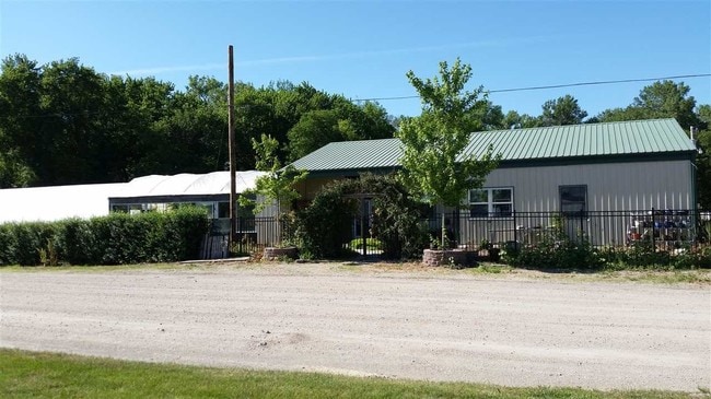
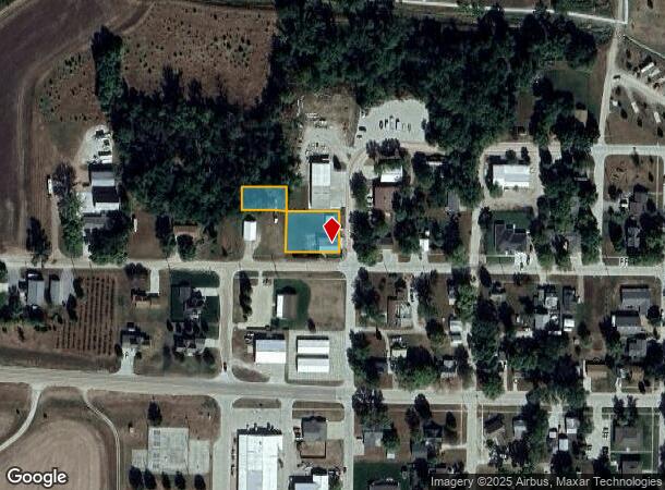
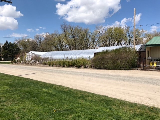
Property Record
900 W Park St, West Point, NE 68788
NEARBY LISTINGS FOR SALE OR LEASE
-
-
View all West Point listings for sale on LoopNet.com
Property Detail
900 W Park St
Other Market Areas
Kings 1St
1062000
KINGS 1ST, LTS 1-2 & ADJ VAC ALLEY, & LT 6, BLK 3, WPC
Commercialnec
Cuming
2024
Nebraska
2025
1-2,6
972800
0.54 AC
2,916 SF
Nebraska Area
DEMOGRAPHICS near 900 W Park St
1 Mile
3 Mile
5 Mile
2024 Total Population
2,757
4,118
4,472
2029 Population
2,770
4,121
4,466
Pop Growth 2024-2029
+ 0.47%
+ 0.07%
(0.13%)
Average Age
40
41
41
2024 Total Households
1,142
1,676
1,819
HH Growth 2024-2029
+ 0.44%
+ 0.06%
(0.11%)
Median Household Inc
$57,659
$64,987
$65,271
Avg Household Size
2.40
2.40
2.40
2024 Avg HH Vehicles
2.00
2.00
2.00
Median Home Value
$105,641
$163,461
$171,543
Median Year Built
1961
1966
1966
Nearby Places
Map Layers
Map Styles
 Street
 Aerial
- Restaurants
- Banks
- Shops
- Fitness
- Groceries
SALE & LEASE HISTORY
LISTING DATE
SALE/LEASE

May 27, 2021
For Sale
Nearby Properties
Address
Land Use
TOTAL SIZE
Lot Size
Zoning
Address
Land Use
TOTAL SIZE
Lot Size
Zoning
119.71 AC
04-INDUSTR
Address
Land Use
TOTAL SIZE
Lot Size
Zoning
10.13 AC
03-COMMERC
Address
Land Use
TOTAL SIZE
Lot Size
Zoning
28,568 SF
2.84 AC
03-COMMERC
Address
Land Use
TOTAL SIZE
Lot Size
Zoning
53,197 SF
13.58 AC
04-INDUSTR
Address
Land Use
TOTAL SIZE
Lot Size
Zoning
15,133 SF
0.79 AC
03-COMMERC
Address
Land Use
TOTAL SIZE
Lot Size
Zoning
65,200 SF
11 AC
03-COMMERC
Address
Land Use
TOTAL SIZE
Lot Size
Zoning
47,392 SF
4.61 AC
04-INDUSTR
Address
Land Use
TOTAL SIZE
Lot Size
Zoning
7,524 SF
4.98 AC
03-COMMERC
Address
Land Use
TOTAL SIZE
Lot Size
Zoning
13,840 SF
1.77 AC
03-COMMERC
Address
Land Use
TOTAL SIZE
Lot Size
Zoning
27,405 SF
1.87 AC
03-COMMERC
Address
Land Use
TOTAL SIZE
Lot Size
Zoning
28,250 SF
3.82 AC
03-COMMERC
Address
Land Use
TOTAL SIZE
Lot Size
Zoning
31,889 SF
3.46 AC
03-COMMERC
Address
Land Use
TOTAL SIZE
Lot Size
Zoning
6,644 SF
0.33 AC
03-COMMERC
Address
Land Use
TOTAL SIZE
Lot Size
Zoning
35,096 SF
1.19 AC
04-INDUSTR
Address
Land Use
TOTAL SIZE
Lot Size
Zoning
12,000 SF
1.89 AC
03-COMMERC
Address
Land Use
TOTAL SIZE
Lot Size
Zoning
3,822 SF
0.78 AC
03-COMMERC
Address
Land Use
TOTAL SIZE
Lot Size
Zoning
4,785 SF
0.20 AC
03-COMMERC
Address
Land Use
TOTAL SIZE
Lot Size
Zoning
6,290 SF
0.20 AC
03-COMMERC
Address
Land Use
TOTAL SIZE
Lot Size
Zoning
18.70 AC
03-COMMERC
Address
Land Use
TOTAL SIZE
Lot Size
Zoning
160 AC
05-AGRICUL
Address
Land Use
TOTAL SIZE
Lot Size
Zoning
1,032 SF
160 AC
05-AGRICUL
Address
Land Use
TOTAL SIZE
Lot Size
Zoning
13,224 SF
0.89 AC
03-COMMERC
Address
Land Use
TOTAL SIZE
Lot Size
Zoning
1,920 SF
162.39 AC
05-AGRICUL
Address
Land Use
TOTAL SIZE
Lot Size
Zoning
15,406 SF
0.94 AC
03-COMMERC
Address
Land Use
TOTAL SIZE
Lot Size
Zoning
22,000 SF
2.25 AC
03-COMMERC
Address
Land Use
TOTAL SIZE
Lot Size
Zoning
22,444 SF
2.24 AC
03-COMMERC
Address
Land Use
TOTAL SIZE
Lot Size
Zoning
1,652 SF
160 AC
05-AGRICUL
Address
Land Use
TOTAL SIZE
Lot Size
Zoning
10,780 SF
1.02 AC
03-COMMERC
Address
Land Use
TOTAL SIZE
Lot Size
Zoning
20,652 SF
0.60 AC
03-COMMERC
The World's #1 Commercial Real Estate Marketplace
Connect with us
© 2026 CoStar Group
The information above has been obtained from sources believed reliable. While we do not doubt its accuracy we have not verified it and make no guarantee, warranty or representation about it. It is your responsibility to independently confirm its accuracy and completeness. Any projections, opinions, assumptions, or estimates used are for example only and do not represent the current or future performance of the property. The value of this transaction to you depends on tax and other factors which should be evaluated by your tax, financial, and legal advisors. You and your advisors should conduct a careful, independent investigation of the property to determine to your satisfaction the suitability of the property for your needs.