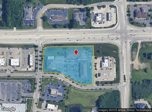
Property Record
9000 76Th St, Pleasant Prairie, WI 53158

NEARBY LISTINGS FOR SALE OR LEASE
Property Detail
9000 76Th St
Chicago-Naperville-Elgin, IL-IN-WI
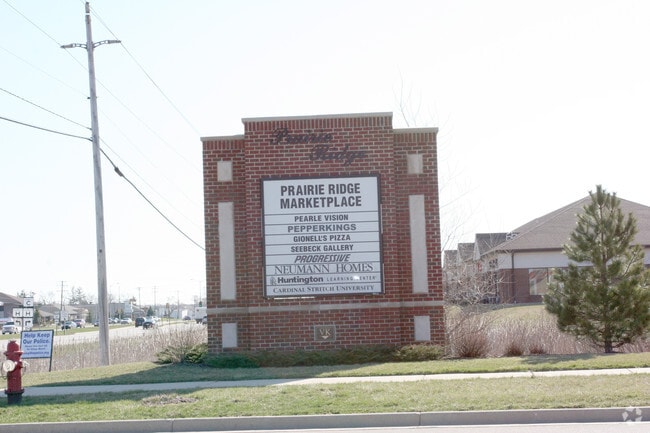
Prairie Ri
91-4-122-081-0110
OUTLOT 19 PRAIRIE RIDGE SUB PLAT #5745 DOC #1088727 PT NE 1/4, NW 1/4, SW 1/4 & SE 1/4 SEC 8 T 1 R 22 EXCP ROW DOC#1847351 TP
Commercialnec
Kenosha
X
Wisconsin
55059C0183D
19
2024
5.05 AC
2024
Kenosha East
002605
Chicago
15,545 SF
DEMOGRAPHICS near 9000 76Th St
1 Mile
3 Mile
5 Mile
2024 Total Population
9,147
32,618
94,589
2029 Population
9,168
32,561
93,692
Pop Growth 2024-2029
+ 0.23%
(0.17%)
(0.95%)
Average Age
39
40
39
2024 Total Households
3,553
12,632
36,629
HH Growth 2024-2029
+ 0.25%
(0.21%)
(0.99%)
Median Household Inc
$92,529
$77,769
$69,740
Avg Household Size
2.50
2.50
2.50
2024 Avg HH Vehicles
2.00
2.00
2.00
Median Home Value
$285,822
$257,933
$215,403
Median Year Built
2000
1990
1972
Nearby Places
Map Layers
Map Styles
 Street
 Aerial
- Restaurants
- Banks
- Shops
- Fitness
- Groceries
PUBLIC TRANSPORTATION
COMMUTER RAIL
Kenosha Station (Union Pacific North Line - Northeast Illinois Regional Commuter Railroad (Metra))
DRIVE
WALK
Distance
Kenosha Station (Union Pacific North Line - Northeast Illinois Regional Commuter Railroad (Metra))
12 min
6.0 mi
AIRPORT
General Mitchell International
DRIVE
WALK
Distance
General Mitchell International
38 min
30.0 mi
SALE & LEASE HISTORY
LISTING DATE
SALE/LEASE

Sep 25, 2016
For Lease
Jul 10, 2019
For Lease
Nearby Properties
Address
Land Use
TOTAL SIZE
Lot Size
Zoning
Address
Land Use
TOTAL SIZE
Lot Size
Zoning
159,194 SF
136.60 AC
Address
Land Use
TOTAL SIZE
Lot Size
Zoning
271,533 SF
125.41 AC
Address
Land Use
TOTAL SIZE
Lot Size
Zoning
176,386 SF
58.38 AC
Address
Land Use
TOTAL SIZE
Lot Size
Zoning
603,010 SF
51.30 AC
Address
Land Use
TOTAL SIZE
Lot Size
Zoning
731,186 SF
81.94 AC
M2
Address
Land Use
TOTAL SIZE
Lot Size
Zoning
67.63 AC
FW
Address
Land Use
TOTAL SIZE
Lot Size
Zoning
12,876 SF
30.13 AC
Address
Land Use
TOTAL SIZE
Lot Size
Zoning
77.22 AC
Address
Land Use
TOTAL SIZE
Lot Size
Zoning
481,854 SF
84.10 AC
FW
Address
Land Use
TOTAL SIZE
Lot Size
Zoning
69,139 SF
12.40 AC
Address
Land Use
TOTAL SIZE
Lot Size
Zoning
57.67 AC
Address
Land Use
TOTAL SIZE
Lot Size
Zoning
606,510 SF
36.02 AC
Address
Land Use
TOTAL SIZE
Lot Size
Zoning
606,510 SF
32.10 AC
Address
Land Use
TOTAL SIZE
Lot Size
Zoning
424,072 SF
29.14 AC
Address
Land Use
TOTAL SIZE
Lot Size
Zoning
16.01 AC
Address
Land Use
TOTAL SIZE
Lot Size
Zoning
47.82 AC
Address
Land Use
TOTAL SIZE
Lot Size
Zoning
850,230 SF
39.46 AC
M2
Address
Land Use
TOTAL SIZE
Lot Size
Zoning
626,520 SF
35.19 AC
M2
Address
Land Use
TOTAL SIZE
Lot Size
Zoning
13.10 AC
Address
Land Use
TOTAL SIZE
Lot Size
Zoning
215,460 SF
40.08 AC
Address
Land Use
TOTAL SIZE
Lot Size
Zoning
20.33 AC
M2
Address
Land Use
TOTAL SIZE
Lot Size
Zoning
35,092 SF
26.34 AC
B2
Address
Land Use
TOTAL SIZE
Lot Size
Zoning
31,809 SF
11.36 AC
BASE
Address
Land Use
TOTAL SIZE
Lot Size
Zoning
50,145 SF
12.76 AC
Address
Land Use
TOTAL SIZE
Lot Size
Zoning
4,643 SF
60 AC
Address
Land Use
TOTAL SIZE
Lot Size
Zoning
15.32 AC
Address
Land Use
TOTAL SIZE
Lot Size
Zoning
253,256 SF
15.22 AC
Address
Land Use
TOTAL SIZE
Lot Size
Zoning
256,810 SF
15.02 AC
Address
Land Use
TOTAL SIZE
Lot Size
Zoning
55,140 SF
21 AC
FW
Address
Land Use
TOTAL SIZE
Lot Size
Zoning
48,284 SF
4.99 AC
The World's #1 Commercial Real Estate Marketplace
Connect with us
© 2025 CoStar Group
The information above has been obtained from sources believed reliable. While we do not doubt its accuracy we have not verified it and make no guarantee, warranty or representation about it. It is your responsibility to independently confirm its accuracy and completeness. Any projections, opinions, assumptions, or estimates used are for example only and do not represent the current or future performance of the property. The value of this transaction to you depends on tax and other factors which should be evaluated by your tax, financial, and legal advisors. You and your advisors should conduct a careful, independent investigation of the property to determine to your satisfaction the suitability of the property for your needs.