Property Record
9000 Co Rd N, Rockford, MN 55373

This Property Is For Sale
NEARBY LISTINGS FOR SALE OR LEASE
Property Detail
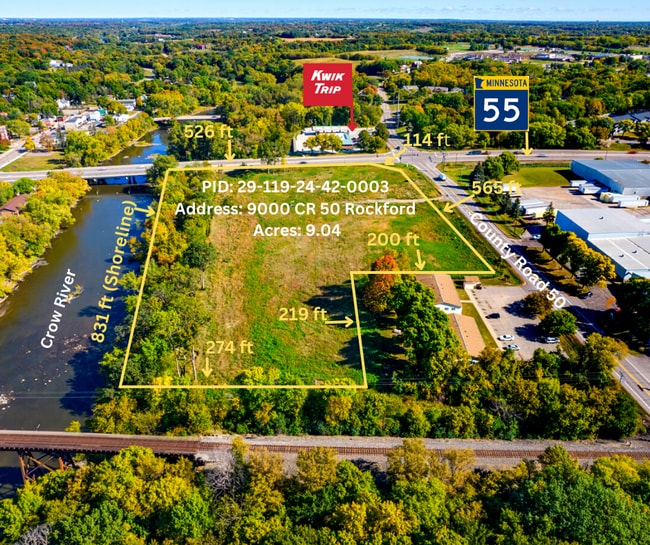
9000 Co Rd N
Minneapolis-St. Paul-Bloomington, MN-WI
Unplatted 29 119 24
29-119-24-42-0003
UNPLATTED 29 119 24 COM AT A PT IN NELY LINE OF SOO LINE R/W DIS 233 13/100 FT NWLY FROM ITS INTERSEC WITH THE CTR LINE OF CO RD NO 50 TH NELY PAR WITH SAID CTR LINE T IRREGULAR
Commercialacreage
Hennepin
AE
Minnesota
27053C0128F
9.04 AC
2024
Northwest
2024
Minneapolis/St Paul
027001
DEMOGRAPHICS near 9000 Co Rd N
1 Mile
3 Mile
5 Mile
2024 Total Population
4,040
8,002
18,646
2029 Population
4,440
8,643
20,139
Pop Growth 2024-2029
+ 9.90%
+ 8.01%
+ 8.01%
Average Age
39
40
40
2024 Total Households
1,597
3,027
6,815
HH Growth 2024-2029
+ 10.14%
+ 8.19%
+ 8.19%
Median Household Inc
$82,491
$95,068
$104,341
Avg Household Size
2.50
2.60
2.70
2024 Avg HH Vehicles
2.00
2.00
2.00
Median Home Value
$206,757
$305,317
$353,089
Median Year Built
1994
1994
1991
Nearby Places
Map Layers
Map Styles
 Street
 Aerial
- Restaurants
- Banks
- Shops
- Fitness
- Groceries
PUBLIC TRANSPORTATION
AIRPORT
Minneapolis-St Paul International/Wold-Chamberlain
DRIVE
WALK
Distance
Minneapolis-St Paul International/Wold-Chamberlain
53 min
37.2 mi
Freight Ports
Port Milwaukee
DRIVE
WALK
Distance
Port Milwaukee
413 min
367.5 mi
Nearby Properties
Address
Land Use
TOTAL SIZE
Lot Size
Zoning
Address
Land Use
TOTAL SIZE
Lot Size
Zoning
4,416 SF
77.41 AC
Address
Land Use
TOTAL SIZE
Lot Size
Zoning
17.68 AC
Address
Land Use
TOTAL SIZE
Lot Size
Zoning
156,250 SF
24.54 AC
Address
Land Use
TOTAL SIZE
Lot Size
Zoning
87,858 SF
30.54 AC
Address
Land Use
TOTAL SIZE
Lot Size
Zoning
Address
Land Use
TOTAL SIZE
Lot Size
Zoning
71,766 SF
12 AC
Address
Land Use
TOTAL SIZE
Lot Size
Zoning
3,850 SF
6.23 AC
Address
Land Use
TOTAL SIZE
Lot Size
Zoning
6.13 AC
Address
Land Use
TOTAL SIZE
Lot Size
Zoning
50,476 SF
5.41 AC
Address
Land Use
TOTAL SIZE
Lot Size
Zoning
4,035 SF
4.86 AC
Address
Land Use
TOTAL SIZE
Lot Size
Zoning
12,248 SF
2.50 AC
Address
Land Use
TOTAL SIZE
Lot Size
Zoning
12,206 SF
2.32 AC
Address
Land Use
TOTAL SIZE
Lot Size
Zoning
4.55 AC
Address
Land Use
TOTAL SIZE
Lot Size
Zoning
9,120 SF
2.13 AC
Address
Land Use
TOTAL SIZE
Lot Size
Zoning
23,880 SF
0.70 AC
Address
Land Use
TOTAL SIZE
Lot Size
Zoning
25,008 SF
1.51 AC
Address
Land Use
TOTAL SIZE
Lot Size
Zoning
6.41 AC
Address
Land Use
TOTAL SIZE
Lot Size
Zoning
12,384 SF
14.77 AC
Address
Land Use
TOTAL SIZE
Lot Size
Zoning
2.63 AC
Address
Land Use
TOTAL SIZE
Lot Size
Zoning
9,807 SF
2 AC
Address
Land Use
TOTAL SIZE
Lot Size
Zoning
46,659 SF
7.50 AC
Address
Land Use
TOTAL SIZE
Lot Size
Zoning
19,640 SF
1.24 AC
Address
Land Use
TOTAL SIZE
Lot Size
Zoning
20,403 SF
1.10 AC
Address
Land Use
TOTAL SIZE
Lot Size
Zoning
Address
Land Use
TOTAL SIZE
Lot Size
Zoning
4.17 AC
Address
Land Use
TOTAL SIZE
Lot Size
Zoning
16,395 SF
2.95 AC
Address
Land Use
TOTAL SIZE
Lot Size
Zoning
4,016 SF
2.79 AC
Address
Land Use
TOTAL SIZE
Lot Size
Zoning
Address
Land Use
TOTAL SIZE
Lot Size
Zoning
The World's #1 Commercial Real Estate Marketplace
Connect with us
© 2026 CoStar Group
The information above has been obtained from sources believed reliable. While we do not doubt its accuracy we have not verified it and make no guarantee, warranty or representation about it. It is your responsibility to independently confirm its accuracy and completeness. Any projections, opinions, assumptions, or estimates used are for example only and do not represent the current or future performance of the property. The value of this transaction to you depends on tax and other factors which should be evaluated by your tax, financial, and legal advisors. You and your advisors should conduct a careful, independent investigation of the property to determine to your satisfaction the suitability of the property for your needs.