Property Record
9000 E 46Th St N, Bel Aire, KS 66722


Current Lease Availabilities
NEARBY LISTINGS FOR SALE OR LEASE
Property Detail
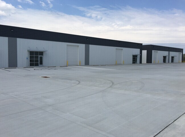
9000 E 46Th St N
Wichita, KS
Bel Aire Industrial Park Add
104-20-0-44-03-004.00
LOT 2 BLOCK 2 BEL AIRE INDUSTRIAL PARK ADD
Warehouse
Sedgwick
X
Kansas
20173C0238G
2
2024
3.65 AC
2025
Northeast
0101061001
Wichita
DEMOGRAPHICS near 9000 E 46Th St N
1 Mile
3 Mile
5 Mile
2024 Total Population
3,364
25,246
67,401
2029 Population
3,399
25,568
68,280
Pop Growth 2024-2029
+ 1.04%
+ 1.28%
+ 1.30%
Average Age
41
40
39
2024 Total Households
1,223
10,342
26,559
HH Growth 2024-2029
+ 0.98%
+ 1.18%
+ 1.16%
Median Household Inc
$99,999
$79,345
$73,768
Avg Household Size
2.60
2.40
2.40
2024 Avg HH Vehicles
2.00
2.00
2.00
Median Home Value
$284,952
$221,008
$229,349
Median Year Built
2002
1993
1990
Nearby Places
Map Layers
Map Styles
 Street
 Aerial
- Restaurants
- Banks
- Shops
- Fitness
- Groceries
PUBLIC TRANSPORTATION
AIRPORT
Wichita Dwight D Eisenhower Ntl
DRIVE
WALK
Distance
Wichita Dwight D Eisenhower Ntl
29 min
19.1 mi
Nearby Properties
Address
Land Use
TOTAL SIZE
Lot Size
Zoning
Address
Land Use
TOTAL SIZE
Lot Size
Zoning
340,322 SF
32.82 AC
SF-5,B
Address
Land Use
TOTAL SIZE
Lot Size
Zoning
256,570 SF
53.92 AC
R3
Address
Land Use
TOTAL SIZE
Lot Size
Zoning
243,768 SF
5.42 AC
LI
Address
Land Use
TOTAL SIZE
Lot Size
Zoning
366,272 SF
332.54 AC
LI
Address
Land Use
TOTAL SIZE
Lot Size
Zoning
129,965 SF
41.88 AC
R3
Address
Land Use
TOTAL SIZE
Lot Size
Zoning
169,134 SF
18.97 AC
SF-5
Address
Land Use
TOTAL SIZE
Lot Size
Zoning
79,739 SF
10.11 AC
R6
Address
Land Use
TOTAL SIZE
Lot Size
Zoning
147,784 SF
39.28 AC
SF-5
Address
Land Use
TOTAL SIZE
Lot Size
Zoning
69,125 SF
16.79 AC
MF-29,MF-1
Address
Land Use
TOTAL SIZE
Lot Size
Zoning
102,200 SF
8.77 AC
R6
Address
Land Use
TOTAL SIZE
Lot Size
Zoning
74,242 SF
23.99 AC
GC
Address
Land Use
TOTAL SIZE
Lot Size
Zoning
67,067 SF
8.36 AC
SF-5
Address
Land Use
TOTAL SIZE
Lot Size
Zoning
74,265 SF
15.01 AC
LC
Address
Land Use
TOTAL SIZE
Lot Size
Zoning
121,541 SF
47.63 AC
LI
Address
Land Use
TOTAL SIZE
Lot Size
Zoning
40,267 SF
10.55 AC
R6
Address
Land Use
TOTAL SIZE
Lot Size
Zoning
92,735 SF
7.28 AC
R4
Address
Land Use
TOTAL SIZE
Lot Size
Zoning
184,788 SF
19.75 AC
M-1
Address
Land Use
TOTAL SIZE
Lot Size
Zoning
70,447 SF
29.66 AC
SF-5,LC
Address
Land Use
TOTAL SIZE
Lot Size
Zoning
60,868 SF
4.17 AC
LI
Address
Land Use
TOTAL SIZE
Lot Size
Zoning
72,002 SF
11.81 AC
LC
Address
Land Use
TOTAL SIZE
Lot Size
Zoning
71,556 SF
19.67 AC
MF-18,MF-2
Address
Land Use
TOTAL SIZE
Lot Size
Zoning
65,637 SF
23.10 AC
SF-5
Address
Land Use
TOTAL SIZE
Lot Size
Zoning
76,382 SF
8.77 AC
R4
Address
Land Use
TOTAL SIZE
Lot Size
Zoning
52,156 SF
5.89 AC
R6
Address
Land Use
TOTAL SIZE
Lot Size
Zoning
91,702 SF
53.96 AC
I-1
Address
Land Use
TOTAL SIZE
Lot Size
Zoning
107,956 SF
3.38 AC
M1
Address
Land Use
TOTAL SIZE
Lot Size
Zoning
39,607 SF
12.81 AC
MF-29
Address
Land Use
TOTAL SIZE
Lot Size
Zoning
38,149 SF
17.12 AC
MF-18,MF-2
Address
Land Use
TOTAL SIZE
Lot Size
Zoning
35,220 SF
7 AC
GO,TF-3
Address
Land Use
TOTAL SIZE
Lot Size
Zoning
34,006 SF
8.01 AC
SF-5
The World's #1 Commercial Real Estate Marketplace
Connect with us
© 2025 CoStar Group
The information above has been obtained from sources believed reliable. While we do not doubt its accuracy we have not verified it and make no guarantee, warranty or representation about it. It is your responsibility to independently confirm its accuracy and completeness. Any projections, opinions, assumptions, or estimates used are for example only and do not represent the current or future performance of the property. The value of this transaction to you depends on tax and other factors which should be evaluated by your tax, financial, and legal advisors. You and your advisors should conduct a careful, independent investigation of the property to determine to your satisfaction the suitability of the property for your needs.