Property Record
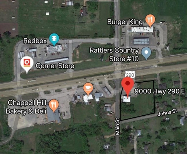
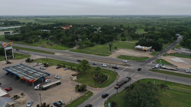
9000 Highway 290 E, Chappell Hill, TX 77426

Property Detail
9000 Highway 290 E
0090-000-06800
A0090 A0090 - MUNSON, WILLIAM, TRACT 68 GIN LOT, ACRES 1.756
Commercialnec
Washington
B and X Area of moderate flood hazard, usually the area between the limits of the 100-year and 500-year floods.
Texas
2025
1.76 AC
2025
Central Texas Area
170601
Other Market Areas
2,512 SF
Brenham, TX
NEARBY LISTINGS FOR SALE OR LEASE
-
-
View all Chappell Hill listings for sale on LoopNet.com
DEMOGRAPHICS near 9000 Highway 290 E
1 mile
3 mile
5 mile
2025 Total Population
532
1,683
2,852
2030 Population
560
1,775
3,003
Pop Growth 2025-2030
+ 5.26%
+ 5.47%
+ 5.29%
Average Age
46
47
46
2025 Total Households
212
677
1,132
HH Growth 2025-2030
+ 6.60%
+ 6.35%
+ 6.27%
Median Household Inc
$92,410
$88,596
$87,630
Avg Household Size
2.40
2.40
2.40
2025 Avg HH Vehicles
2.00
2.00
2.00
Median Home Value
$422,222
$393,430
$392,640
Median Year Built
1999
2000
2000
Nearby Places
Map Layers
Map Styles
 Street
 Aerial
Layers
 Traffic
 Biking
Places
Listings with unknown addresses are not visible on the map
- Restaurants
- Banks
- Shops
- Fitness
- Groceries
SALE & LEASE HISTORY
LISTING DATE
SALE/LEASE

Sep 15, 2020
For Sale
Feb 13, 2020
For Sale
Feb 03, 2020
For Sale
Aug 15, 2019
For Lease
Nearby Properties
Address
Land Use
TOTAL SIZE
Lot Size
Zoning
Address
Land Use
TOTAL SIZE
Lot Size
Zoning
26,964 SF
16.05 AC
Address
Land Use
TOTAL SIZE
Lot Size
Zoning
21,835 SF
51.02 AC
Address
Land Use
TOTAL SIZE
Lot Size
Zoning
3,300 SF
225.57 AC
Address
Land Use
TOTAL SIZE
Lot Size
Zoning
30,208 SF
25.42 AC
Address
Land Use
TOTAL SIZE
Lot Size
Zoning
132.01 AC
Address
Land Use
TOTAL SIZE
Lot Size
Zoning
Address
Land Use
TOTAL SIZE
Lot Size
Zoning
3,600 SF
104.65 AC
Address
Land Use
TOTAL SIZE
Lot Size
Zoning
76,000 SF
97 AC
Address
Land Use
TOTAL SIZE
Lot Size
Zoning
3,613 SF
30 AC
Address
Land Use
TOTAL SIZE
Lot Size
Zoning
5,900 SF
5.66 AC
Address
Land Use
TOTAL SIZE
Lot Size
Zoning
157.30 AC
Address
Land Use
TOTAL SIZE
Lot Size
Zoning
8,610 SF
2.83 AC
Address
Land Use
TOTAL SIZE
Lot Size
Zoning
26,492 SF
5.90 AC
Address
Land Use
TOTAL SIZE
Lot Size
Zoning
295.31 AC
Address
Land Use
TOTAL SIZE
Lot Size
Zoning
83.33 AC
Address
Land Use
TOTAL SIZE
Lot Size
Zoning
87.64 AC
Address
Land Use
TOTAL SIZE
Lot Size
Zoning
4,193 SF
75.28 AC
Address
Land Use
TOTAL SIZE
Lot Size
Zoning
1,325 SF
63.23 AC
Address
Land Use
TOTAL SIZE
Lot Size
Zoning
540 SF
131.03 AC
Address
Land Use
TOTAL SIZE
Lot Size
Zoning
1,954 SF
73.91 AC
Address
Land Use
TOTAL SIZE
Lot Size
Zoning
2,918 SF
36.86 AC
Address
Land Use
TOTAL SIZE
Lot Size
Zoning
216 SF
118.56 AC
Address
Land Use
TOTAL SIZE
Lot Size
Zoning
61.33 AC
Address
Land Use
TOTAL SIZE
Lot Size
Zoning
12,231 SF
8 AC
Address
Land Use
TOTAL SIZE
Lot Size
Zoning
2,650 SF
67.39 AC
Address
Land Use
TOTAL SIZE
Lot Size
Zoning
256 SF
63.23 AC
Address
Land Use
TOTAL SIZE
Lot Size
Zoning
49.22 AC
Address
Land Use
TOTAL SIZE
Lot Size
Zoning
1,350 SF
49.05 AC
Address
Land Use
TOTAL SIZE
Lot Size
Zoning
145 SF
62.23 AC
Address
Land Use
TOTAL SIZE
Lot Size
Zoning
19,065 SF
58.33 AC
The World's #1 Commercial Real Estate Marketplace
Connect with us
© 2026 CoStar Group
The information above has been obtained from sources believed reliable. While we do not doubt its accuracy we have not verified it and make no guarantee, warranty or representation about it. It is your responsibility to independently confirm its accuracy and completeness. Any projections, opinions, assumptions, or estimates used are for example only and do not represent the current or future performance of the property. The value of this transaction to you depends on tax and other factors which should be evaluated by your tax, financial, and legal advisors. You and your advisors should conduct a careful, independent investigation of the property to determine to your satisfaction the suitability of the property for your needs.