Property Record
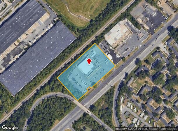
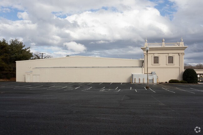
9000 Pulaski Hwy, Middle River, MD 21220


NEARBY LISTINGS FOR SALE OR LEASE
Property Detail
9000 Pulaski Hwy
15-1516900560
3.913 AC NWS
Restaurantbuilding
Baltimore
X
Maryland
2400100430H
3.91 AC
2024
Baltimore County East
2025
Baltimore
451200
Baltimore-Columbia-Towson, MD
26,604 SF
DEMOGRAPHICS near 9000 Pulaski Hwy
1 Mile
3 Mile
5 Mile
2024 Total Population
10,771
93,787
254,627
2029 Population
10,660
92,631
249,205
Pop Growth 2024-2029
(1.03%)
(1.23%)
(2.13%)
Average Age
39
40
40
2024 Total Households
4,184
36,241
99,453
HH Growth 2024-2029
(1.05%)
(1.34%)
(2.26%)
Median Household Inc
$60,877
$69,833
$72,162
Avg Household Size
2.40
2.50
2.50
2024 Avg HH Vehicles
2.00
2.00
2.00
Median Home Value
$256,352
$249,913
$251,458
Median Year Built
1979
1974
1969
Nearby Places
Map Layers
Map Styles
 Street
 Aerial
- Restaurants
- Banks
- Shops
- Fitness
- Groceries
PUBLIC TRANSPORTATION
COMMUTER RAIL
Martin State Airport (PENN - WASHINGTON - Maryland Area Regional Commuter Trains (The MARC), Penn Line - Maryland Area Regional Commuter Trains (The MARC))
DRIVE
WALK
Distance
Martin State Airport (PENN - WASHINGTON - Maryland Area Regional Commuter Trains (The MARC), Penn Line - Maryland Area Regional Commuter Trains (The MARC))
7 min
3.4 mi
Penn Station (PENN - WASHINGTON - Maryland Area Regional Commuter Trains (The MARC), Penn Line - Maryland Area Regional Commuter Trains (The MARC), Penn Station & Camden Yards - Maryland Area Regional Commuter Trains (The MARC))
DRIVE
WALK
Distance
Penn Station (PENN - WASHINGTON - Maryland Area Regional Commuter Trains (The MARC), Penn Line - Maryland Area Regional Commuter Trains (The MARC), Penn Station & Camden Yards - Maryland Area Regional Commuter Trains (The MARC))
21 min
9.7 mi
AIRPORT
Baltimore/Washington International Thurgood Marshall
DRIVE
WALK
Distance
Baltimore/Washington International Thurgood Marshall
33 min
20.9 mi
Freight Ports
Port of Baltimore
DRIVE
WALK
Distance
Port of Baltimore
19 min
11.3 mi
SALE & LEASE HISTORY
LISTING DATE
SALE/LEASE

Jul 17, 2020
For Lease
Jul 17, 2020
For Sale
Nearby Properties
Address
Land Use
TOTAL SIZE
Lot Size
Zoning
Address
Land Use
TOTAL SIZE
Lot Size
Zoning
307,785 SF
30.50 AC
ML
Address
Land Use
TOTAL SIZE
Lot Size
Zoning
119,200 SF
57.12 AC
Address
Land Use
TOTAL SIZE
Lot Size
Zoning
527,364 SF
18.11 AC
BM
Address
Land Use
TOTAL SIZE
Lot Size
Zoning
46.20 AC
DR105
Address
Land Use
TOTAL SIZE
Lot Size
Zoning
474,640 SF
12.42 AC
Address
Land Use
TOTAL SIZE
Lot Size
Zoning
560,700 SF
25.77 AC
Address
Land Use
TOTAL SIZE
Lot Size
Zoning
85,474 SF
22.22 AC
Address
Land Use
TOTAL SIZE
Lot Size
Zoning
584,740 SF
32.61 AC
Address
Land Use
TOTAL SIZE
Lot Size
Zoning
21.74 AC
DR16
Address
Land Use
TOTAL SIZE
Lot Size
Zoning
15.29 AC
Address
Land Use
TOTAL SIZE
Lot Size
Zoning
101,906 SF
13.54 AC
Address
Land Use
TOTAL SIZE
Lot Size
Zoning
105,384 SF
11.52 AC
Address
Land Use
TOTAL SIZE
Lot Size
Zoning
12.20 AC
DR16
Address
Land Use
TOTAL SIZE
Lot Size
Zoning
1,062,672 SF
70.27 AC
MHIM
Address
Land Use
TOTAL SIZE
Lot Size
Zoning
9.27 AC
DR105
Address
Land Use
TOTAL SIZE
Lot Size
Zoning
15.40 AC
DR16
Address
Land Use
TOTAL SIZE
Lot Size
Zoning
427,720 SF
27.55 AC
ML
Address
Land Use
TOTAL SIZE
Lot Size
Zoning
507,600 SF
21.36 AC
MHIM
Address
Land Use
TOTAL SIZE
Lot Size
Zoning
105,384 SF
15.41 AC
Address
Land Use
TOTAL SIZE
Lot Size
Zoning
12.81 AC
DR16
Address
Land Use
TOTAL SIZE
Lot Size
Zoning
12.09 AC
DR5.5
Address
Land Use
TOTAL SIZE
Lot Size
Zoning
9.79 AC
DR5.5
Address
Land Use
TOTAL SIZE
Lot Size
Zoning
14.28 AC
DR16
Address
Land Use
TOTAL SIZE
Lot Size
Zoning
271,370 SF
20.11 AC
BM
Address
Land Use
TOTAL SIZE
Lot Size
Zoning
117,170 SF
7.84 AC
BM
Address
Land Use
TOTAL SIZE
Lot Size
Zoning
253,081 SF
42.21 AC
DR5.5
Address
Land Use
TOTAL SIZE
Lot Size
Zoning
300,400 SF
31.60 AC
ML-IM
Address
Land Use
TOTAL SIZE
Lot Size
Zoning
135,931 SF
21.65 AC
DR5.5
Address
Land Use
TOTAL SIZE
Lot Size
Zoning
192 SF
11.09 AC
Address
Land Use
TOTAL SIZE
Lot Size
Zoning
97,878 SF
12.45 AC
DR5.5
The World's #1 Commercial Real Estate Marketplace
Connect with us
© 2025 CoStar Group
The information above has been obtained from sources believed reliable. While we do not doubt its accuracy we have not verified it and make no guarantee, warranty or representation about it. It is your responsibility to independently confirm its accuracy and completeness. Any projections, opinions, assumptions, or estimates used are for example only and do not represent the current or future performance of the property. The value of this transaction to you depends on tax and other factors which should be evaluated by your tax, financial, and legal advisors. You and your advisors should conduct a careful, independent investigation of the property to determine to your satisfaction the suitability of the property for your needs.