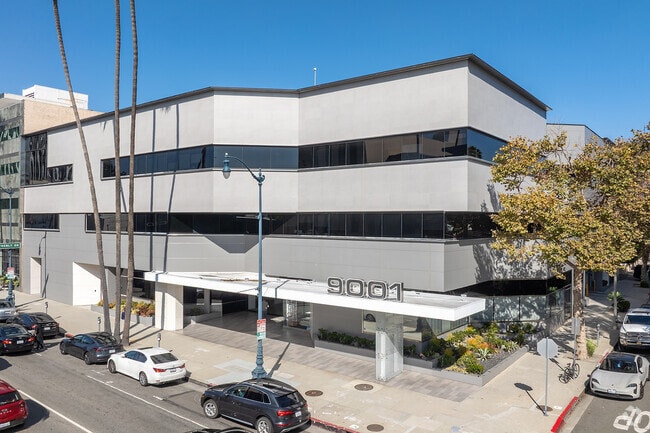
Property Record
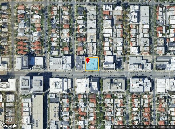
9001 Wilshire Blvd, Beverly Hills, CA 90211


Current Lease Availabilities
NEARBY LISTINGS FOR SALE OR LEASE
Property Detail
9001 Wilshire Blvd
Los Angeles-Long Beach-Glendale, CA
7005
4335-028-085
TR=7005 EX OF ALLEY LOTS 283,284 AND 285
Officebuilding
Los Angeles
X
California
06037C1585F
283-2
2024
0.49 AC
2025
Beverly Hills
700802
Los Angeles
49,224 SF
DEMOGRAPHICS near 9001 Wilshire Blvd
1 Mile
3 Mile
5 Mile
2024 Total Population
42,754
296,555
814,497
2029 Population
41,971
290,151
799,736
Pop Growth 2024-2029
(1.83%)
(2.16%)
(1.81%)
Average Age
43
42
40
2024 Total Households
21,063
143,335
365,150
HH Growth 2024-2029
(2.01%)
(2.35%)
(1.97%)
Median Household Inc
$95,136
$96,235
$81,419
Avg Household Size
2.00
2.00
2.10
2024 Avg HH Vehicles
1.00
1.00
1.00
Median Home Value
$1,102,358
$1,100,202
$1,080,526
Median Year Built
1965
1961
1964
Nearby Places
Map Layers
Map Styles
 Street
 Aerial
- Restaurants
- Banks
- Shops
- Fitness
- Groceries
PUBLIC TRANSPORTATION
AIRPORT
Los Angeles International
DRIVE
WALK
Distance
Los Angeles International
21 min
11.1 mi
Bob Hope
DRIVE
WALK
Distance
Bob Hope
26 min
13.8 mi
Long Beach (Daugherty Field)
DRIVE
WALK
Distance
Long Beach (Daugherty Field)
39 min
27.6 mi
Freight Ports
Port of Long Beach
DRIVE
WALK
Distance
Port of Long Beach
42 min
29.4 mi
Nearby Properties
Address
Land Use
TOTAL SIZE
Lot Size
Zoning
Address
Land Use
TOTAL SIZE
Lot Size
Zoning
1,436,724 SF
21.11 AC
LAC2
Address
Land Use
TOTAL SIZE
Lot Size
Zoning
2,529,036 SF
8.48 AC
LAC2
Address
Land Use
TOTAL SIZE
Lot Size
Zoning
1,447,077 SF
10.63 AC
LAC2
Address
Land Use
TOTAL SIZE
Lot Size
Zoning
436,774 SF
1.49 AC
LAC2
Address
Land Use
TOTAL SIZE
Lot Size
Zoning
597,158 SF
2.15 AC
LAC2
Address
Land Use
TOTAL SIZE
Lot Size
Zoning
1,353,044 SF
6.18 AC
LAC2
Address
Land Use
TOTAL SIZE
Lot Size
Zoning
1,002,990 SF
8.42 AC
LAC4
Address
Land Use
TOTAL SIZE
Lot Size
Zoning
227,227 SF
7.62 AC
BHC3*
Address
Land Use
TOTAL SIZE
Lot Size
Zoning
5.57 AC
LAC2
Address
Land Use
TOTAL SIZE
Lot Size
Zoning
33,373 SF
52.98 AC
LACCS
Address
Land Use
TOTAL SIZE
Lot Size
Zoning
840,124 SF
2.77 AC
LAC2
Address
Land Use
TOTAL SIZE
Lot Size
Zoning
252,523 SF
2.26 AC
LAC2
Address
Land Use
TOTAL SIZE
Lot Size
Zoning
636,436 SF
6.62 AC
LAC2
Address
Land Use
TOTAL SIZE
Lot Size
Zoning
1,232,625 SF
2.40 AC
LAC2
Address
Land Use
TOTAL SIZE
Lot Size
Zoning
1,226,598 SF
2.30 AC
LAC2
Address
Land Use
TOTAL SIZE
Lot Size
Zoning
32,180 SF
BHC3*
Address
Land Use
TOTAL SIZE
Lot Size
Zoning
824,156 SF
2.15 AC
LAC2
Address
Land Use
TOTAL SIZE
Lot Size
Zoning
767,078 SF
9.30 AC
LAC2
Address
Land Use
TOTAL SIZE
Lot Size
Zoning
871,235 SF
14.56 AC
LAC2
Address
Land Use
TOTAL SIZE
Lot Size
Zoning
476,779 SF
1.57 AC
LAC4
Address
Land Use
TOTAL SIZE
Lot Size
Zoning
133,959 SF
1.23 AC
BHC3*
Address
Land Use
TOTAL SIZE
Lot Size
Zoning
754,581 SF
3.75 AC
LAC1
Address
Land Use
TOTAL SIZE
Lot Size
Zoning
728,063 SF
2.08 AC
LAC4
Address
Land Use
TOTAL SIZE
Lot Size
Zoning
472,363 SF
3.24 AC
LAC4
Address
Land Use
TOTAL SIZE
Lot Size
Zoning
515,531 SF
14.65 AC
LAC2
Address
Land Use
TOTAL SIZE
Lot Size
Zoning
808,626 SF
1.88 AC
LAC2
Address
Land Use
TOTAL SIZE
Lot Size
Zoning
368,411 SF
10.91 AC
C2-2D-CPIO
Address
Land Use
TOTAL SIZE
Lot Size
Zoning
793,274 SF
7.80 AC
LAR4
Address
Land Use
TOTAL SIZE
Lot Size
Zoning
110,580 SF
6.88 AC
LAC2
Address
Land Use
TOTAL SIZE
Lot Size
Zoning
125,170 SF
The World's #1 Commercial Real Estate Marketplace
Connect with us
© 2025 CoStar Group
The information above has been obtained from sources believed reliable. While we do not doubt its accuracy we have not verified it and make no guarantee, warranty or representation about it. It is your responsibility to independently confirm its accuracy and completeness. Any projections, opinions, assumptions, or estimates used are for example only and do not represent the current or future performance of the property. The value of this transaction to you depends on tax and other factors which should be evaluated by your tax, financial, and legal advisors. You and your advisors should conduct a careful, independent investigation of the property to determine to your satisfaction the suitability of the property for your needs.