Property Record
9003 Palladay Rd, Elverta, CA 95626

NEARBY LISTINGS FOR SALE OR LEASE
Property Detail
9003 Palladay Rd
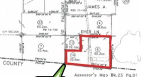
023-010-006
Colburn James A. Estate
Residentialnec
32.62 A FR SEC 9 10 5
X
Placer
06061C1010H
California
2024
55.27 AC
2025
Roseville/Rocklin
021327
Sacramento
96 SF
Sacramento-Roseville-Folsom, CA
DEMOGRAPHICS near 9003 Palladay Rd
1 mile
3 mile
5 mile
2024 Total Population
92
19,450
113,223
2029 Population
90
19,432
115,964
Pop Growth 2024-2029
(2.17%)
(0.09%)
+ 2.42%
Average Age
43
39
38
2024 Total Households
31
6,145
36,257
HH Growth 2024-2029
0.00%
(0.11%)
+ 2.58%
Median Household Inc
$96,428
$90,408
$89,799
Avg Household Size
2.90
3.10
3.10
2024 Avg HH Vehicles
3.00
2.00
2.00
Median Home Value
$487,499
$456,713
$472,272
Median Year Built
1982
1982
1990
Nearby Places
Map Layers
Map Styles
 Street
 Aerial
Transit
 Traffic
 Biking
Places
Listings with unknown addresses are not visible on the map
- Restaurants
- Banks
- Shops
- Fitness
- Groceries
PUBLIC TRANSPORTATION
COMMUTER RAIL
Roseville (California Zephyr - Amtrak, Capitol Corridor - Amtrak)
Drive
Walk
Distance
Roseville (California Zephyr - Amtrak, Capitol Corridor - Amtrak)
20 min
9.7 mi
AIRPORT
Sacramento International
Drive
Walk
Distance
Sacramento International
28 min
16.9 mi
Freight Ports
Port of Stockton
Drive
Walk
Distance
Port of Stockton
80 min
65.4 mi
Nearby Properties
Address
Land Use
TOTAL SIZE
Lot Size
Zoning
Address
Land Use
TOTAL SIZE
Lot Size
Zoning
29.68 AC
Address
Land Use
TOTAL SIZE
Lot Size
Zoning
124,819 SF
13.10 AC
SC
Address
Land Use
TOTAL SIZE
Lot Size
Zoning
25.88 AC
Address
Land Use
TOTAL SIZE
Lot Size
Zoning
Address
Land Use
TOTAL SIZE
Lot Size
Zoning
48.60 AC
Address
Land Use
TOTAL SIZE
Lot Size
Zoning
53.76 AC
RD-5
Address
Land Use
TOTAL SIZE
Lot Size
Zoning
86,400 SF
7.17 AC
GC
Address
Land Use
TOTAL SIZE
Lot Size
Zoning
49,052 SF
6.27 AC
RD-20
Address
Land Use
TOTAL SIZE
Lot Size
Zoning
21.50 AC
RD-5
Address
Land Use
TOTAL SIZE
Lot Size
Zoning
276.90 AC
FBX
Address
Land Use
TOTAL SIZE
Lot Size
Zoning
1,308 SF
56 AC
SPLPVSP
Address
Land Use
TOTAL SIZE
Lot Size
Zoning
24,949 SF
1.01 AC
RD-20
Address
Land Use
TOTAL SIZE
Lot Size
Zoning
16.08 AC
Address
Land Use
TOTAL SIZE
Lot Size
Zoning
1,752 SF
239.40 AC
SPLPVSP
Address
Land Use
TOTAL SIZE
Lot Size
Zoning
27,092 SF
5.53 AC
AR-5
Address
Land Use
TOTAL SIZE
Lot Size
Zoning
3,136 SF
17.31 AC
Address
Land Use
TOTAL SIZE
Lot Size
Zoning
7,009 SF
0.99 AC
SC
Address
Land Use
TOTAL SIZE
Lot Size
Zoning
7,157 SF
79.40 AC
FBX
Address
Land Use
TOTAL SIZE
Lot Size
Zoning
14,077 SF
1.97 AC
LC
Address
Land Use
TOTAL SIZE
Lot Size
Zoning
8.58 AC
Address
Land Use
TOTAL SIZE
Lot Size
Zoning
4,592 SF
19.10 AC
FBX
Address
Land Use
TOTAL SIZE
Lot Size
Zoning
102,750 SF
8.96 AC
GC
Address
Land Use
TOTAL SIZE
Lot Size
Zoning
3,461 SF
0.27 AC
GC
Address
Land Use
TOTAL SIZE
Lot Size
Zoning
1,107 SF
4.79 AC
M-1
The World's #1 Commercial Real Estate Marketplace
Connect with us
© 2026 CoStar Group
The information above has been obtained from sources believed reliable. While we do not doubt its accuracy we have not verified it and make no guarantee, warranty or representation about it. It is your responsibility to independently confirm its accuracy and completeness. Any projections, opinions, assumptions, or estimates used are for example only and do not represent the current or future performance of the property. The value of this transaction to you depends on tax and other factors which should be evaluated by your tax, financial, and legal advisors. You and your advisors should conduct a careful, independent investigation of the property to determine to your satisfaction the suitability of the property for your needs.