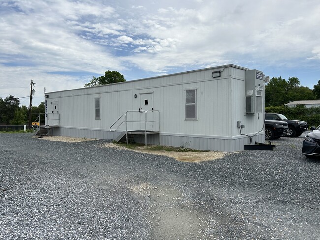
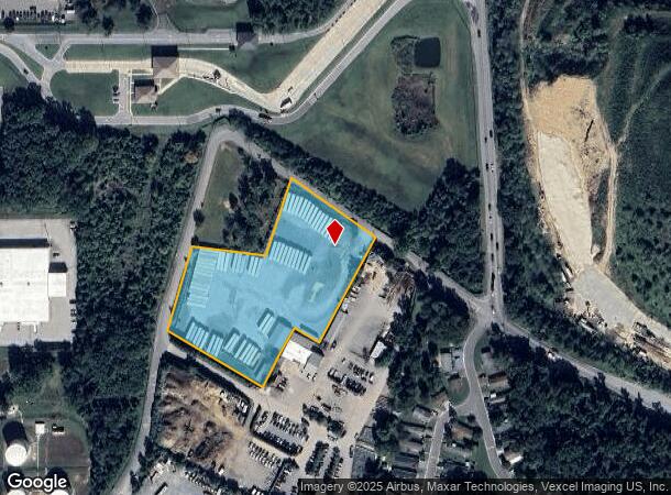
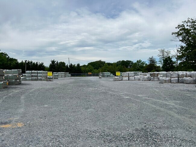
Property Record
9007 Dower House Rd W, Upper Marlboro, MD 20772
Current Lease Availabilities
NEARBY LISTINGS FOR SALE OR LEASE
Property Detail
9007 Dower House Rd W
09-0876805
N CONF USE-HOUSE
Commercialacreage
Prince George's
X
Maryland
24033C0265E
3.82 AC
2024
Branch Avenue Corridor
2025
Washington, DC
801214
Washington-Arlington-Alexandria, DC-VA-MD-WV
980 SF
DEMOGRAPHICS near 9007 Dower House Rd W
1 Mile
3 Mile
5 Mile
2024 Total Population
2,437
35,412
146,298
2029 Population
2,370
34,996
142,914
Pop Growth 2024-2029
(2.75%)
(1.17%)
(2.31%)
Average Age
43
40
41
2024 Total Households
868
12,981
54,306
HH Growth 2024-2029
(2.88%)
(1.25%)
(2.41%)
Median Household Inc
$102,273
$117,046
$100,573
Avg Household Size
2.80
2.70
2.60
2024 Avg HH Vehicles
2.00
2.00
2.00
Median Home Value
$416,745
$437,190
$367,574
Median Year Built
1989
1993
1982
Nearby Places
Map Layers
Map Styles
 Street
 Aerial
- Restaurants
- Banks
- Shops
- Fitness
- Groceries
PUBLIC TRANSPORTATION
AIRPORT
Ronald Reagan Washington Ntl
DRIVE
WALK
Distance
Ronald Reagan Washington Ntl
30 min
16.5 mi
Baltimore/Washington International Thurgood Marshall
DRIVE
WALK
Distance
Baltimore/Washington International Thurgood Marshall
51 min
34.1 mi
Freight Ports
Port of Baltimore
DRIVE
WALK
Distance
Port of Baltimore
61 min
40.7 mi
Nearby Properties
Address
Land Use
TOTAL SIZE
Lot Size
Zoning
Address
Land Use
TOTAL SIZE
Lot Size
Zoning
203.33 AC
IE
Address
Land Use
TOTAL SIZE
Lot Size
Zoning
386,775 SF
45.40 AC
RMF20
Address
Land Use
TOTAL SIZE
Lot Size
Zoning
111.87 AC
IE
Address
Land Use
TOTAL SIZE
Lot Size
Zoning
98.14 AC
IE
Address
Land Use
TOTAL SIZE
Lot Size
Zoning
73.26 AC
IE
Address
Land Use
TOTAL SIZE
Lot Size
Zoning
223,600 SF
13.34 AC
IE
Address
Land Use
TOTAL SIZE
Lot Size
Zoning
117.45 AC
IE
Address
Land Use
TOTAL SIZE
Lot Size
Zoning
124.59 AC
IE
Address
Land Use
TOTAL SIZE
Lot Size
Zoning
4,059 SF
16.82 AC
IE
Address
Land Use
TOTAL SIZE
Lot Size
Zoning
133,840 SF
33.35 AC
IE
Address
Land Use
TOTAL SIZE
Lot Size
Zoning
74.38 AC
IE
Address
Land Use
TOTAL SIZE
Lot Size
Zoning
111.72 AC
IE
Address
Land Use
TOTAL SIZE
Lot Size
Zoning
117.87 AC
IE
Address
Land Use
TOTAL SIZE
Lot Size
Zoning
269.41 AC
IE
Address
Land Use
TOTAL SIZE
Lot Size
Zoning
157.68 AC
IE
Address
Land Use
TOTAL SIZE
Lot Size
Zoning
138.27 AC
IE
Address
Land Use
TOTAL SIZE
Lot Size
Zoning
358,700 SF
12.24 AC
TACE
Address
Land Use
TOTAL SIZE
Lot Size
Zoning
250.35 AC
IE
Address
Land Use
TOTAL SIZE
Lot Size
Zoning
216,875 SF
8.75 AC
IE
Address
Land Use
TOTAL SIZE
Lot Size
Zoning
207,504 SF
8.84 AC
I1
Address
Land Use
TOTAL SIZE
Lot Size
Zoning
115,888 SF
12.36 AC
CGO
Address
Land Use
TOTAL SIZE
Lot Size
Zoning
116,550 SF
15.60 AC
IE
Address
Land Use
TOTAL SIZE
Lot Size
Zoning
102 AC
IE
Address
Land Use
TOTAL SIZE
Lot Size
Zoning
166,425 SF
10.51 AC
IE
Address
Land Use
TOTAL SIZE
Lot Size
Zoning
160,870 SF
3.75 AC
RMF48
Address
Land Use
TOTAL SIZE
Lot Size
Zoning
174,894 SF
7.54 AC
CGO
Address
Land Use
TOTAL SIZE
Lot Size
Zoning
55,724 SF
10.09 AC
IE
Address
Land Use
TOTAL SIZE
Lot Size
Zoning
126,296 SF
34.87 AC
IE
Address
Land Use
TOTAL SIZE
Lot Size
Zoning
67.32 AC
IE
Address
Land Use
TOTAL SIZE
Lot Size
Zoning
115,500 SF
3.10 AC
IE
The World's #1 Commercial Real Estate Marketplace
Connect with us
© 2026 CoStar Group
The information above has been obtained from sources believed reliable. While we do not doubt its accuracy we have not verified it and make no guarantee, warranty or representation about it. It is your responsibility to independently confirm its accuracy and completeness. Any projections, opinions, assumptions, or estimates used are for example only and do not represent the current or future performance of the property. The value of this transaction to you depends on tax and other factors which should be evaluated by your tax, financial, and legal advisors. You and your advisors should conduct a careful, independent investigation of the property to determine to your satisfaction the suitability of the property for your needs.