Property Record
9009 Ramin St, Houston, TX 77093
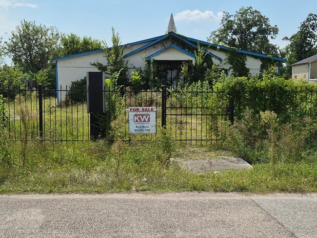
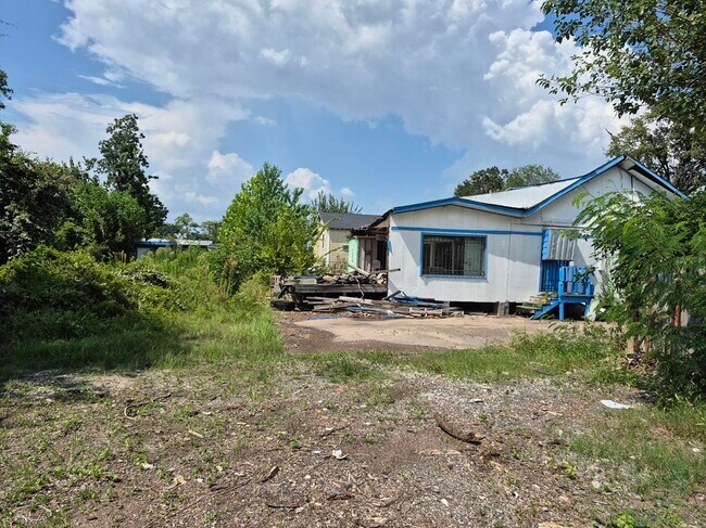
This Property Is For Sale
NEARBY LISTINGS FOR SALE OR LEASE
Property Detail
9009 Ramin St
0422320010026
Dodson Acres U/R
Religious
TR 5A BLK 1 DODSON ACRES U/R ABST 329 J T HARRELL
X
Harris
48201C0680L
Texas
0
0.45 AC
2025
Northeast Near
220900
Houston
2,647 SF
Houston-The Woodlands-Sugar Land, TX
DEMOGRAPHICS near 9009 Ramin St
1 Mile
3 Mile
5 Mile
2024 Total Population
12,414
121,102
333,879
2029 Population
13,280
129,656
358,537
Pop Growth 2024-2029
+ 6.98%
+ 7.06%
+ 7.39%
Average Age
37
37
37
2024 Total Households
3,926
38,158
112,411
HH Growth 2024-2029
+ 7.18%
+ 7.33%
+ 7.72%
Median Household Inc
$36,709
$45,308
$50,183
Avg Household Size
3.10
3.10
2.90
2024 Avg HH Vehicles
2.00
2.00
2.00
Median Home Value
$160,060
$168,156
$198,503
Median Year Built
1963
1961
1966
Nearby Places
- Restaurants
- Banks
- Shops
- Fitness
- Groceries
PUBLIC TRANSPORTATION
COMMUTER RAIL
DRIVE
WALK
Distance
13 min
7.2 mi
AIRPORT
George Bush Intcntl/Houston
DRIVE
WALK
Distance
George Bush Intcntl/Houston
18 min
12.5 mi
William P Hobby
DRIVE
WALK
Distance
William P Hobby
31 min
18.2 mi
Freight Ports
Port of Houston
DRIVE
WALK
Distance
Port of Houston
20 min
11.9 mi
Nearby Properties
Address
Land Use
TOTAL SIZE
Lot Size
Zoning
Address
Land Use
TOTAL SIZE
Lot Size
Zoning
474,326 SF
43.16 AC
Address
Land Use
TOTAL SIZE
Lot Size
Zoning
545,628 SF
19.41 AC
Address
Land Use
TOTAL SIZE
Lot Size
Zoning
188,582 SF
17.94 AC
Address
Land Use
TOTAL SIZE
Lot Size
Zoning
304,925 SF
10.91 AC
Address
Land Use
TOTAL SIZE
Lot Size
Zoning
91,623 SF
9.09 AC
Address
Land Use
TOTAL SIZE
Lot Size
Zoning
234,016 SF
7.75 AC
Address
Land Use
TOTAL SIZE
Lot Size
Zoning
219,230 SF
9.92 AC
Address
Land Use
TOTAL SIZE
Lot Size
Zoning
55,517 SF
13 AC
Address
Land Use
TOTAL SIZE
Lot Size
Zoning
112,212 SF
10.51 AC
Address
Land Use
TOTAL SIZE
Lot Size
Zoning
130,309 SF
13.28 AC
Address
Land Use
TOTAL SIZE
Lot Size
Zoning
82,951 SF
21.32 AC
Address
Land Use
TOTAL SIZE
Lot Size
Zoning
51,941 SF
3.71 AC
Address
Land Use
TOTAL SIZE
Lot Size
Zoning
102,214 SF
11.26 AC
Address
Land Use
TOTAL SIZE
Lot Size
Zoning
186,629 SF
9.75 AC
Address
Land Use
TOTAL SIZE
Lot Size
Zoning
67,380 SF
1.81 AC
Address
Land Use
TOTAL SIZE
Lot Size
Zoning
136,996 SF
29.18 AC
Address
Land Use
TOTAL SIZE
Lot Size
Zoning
129,204 SF
7.03 AC
Address
Land Use
TOTAL SIZE
Lot Size
Zoning
122,305 SF
16.08 AC
Address
Land Use
TOTAL SIZE
Lot Size
Zoning
164,377 SF
32.46 AC
Address
Land Use
TOTAL SIZE
Lot Size
Zoning
88,948 SF
6.31 AC
Address
Land Use
TOTAL SIZE
Lot Size
Zoning
120,288 SF
9.30 AC
Address
Land Use
TOTAL SIZE
Lot Size
Zoning
105,191 SF
4.56 AC
Address
Land Use
TOTAL SIZE
Lot Size
Zoning
88,462 SF
6.93 AC
Address
Land Use
TOTAL SIZE
Lot Size
Zoning
68,140 SF
8.49 AC
Address
Land Use
TOTAL SIZE
Lot Size
Zoning
148,266 SF
9.16 AC
Address
Land Use
TOTAL SIZE
Lot Size
Zoning
79,260 SF
Address
Land Use
TOTAL SIZE
Lot Size
Zoning
81,225 SF
5.03 AC
Address
Land Use
TOTAL SIZE
Lot Size
Zoning
104,553 SF
11.28 AC
Address
Land Use
TOTAL SIZE
Lot Size
Zoning
62,858 SF
11.69 AC
Address
Land Use
TOTAL SIZE
Lot Size
Zoning
142,170 SF
6.99 AC
The World's #1 Commercial Real Estate Marketplace
Connect with us
© 2025 CoStar Group
The information above has been obtained from sources believed reliable. While we do not doubt its accuracy we have not verified it and make no guarantee, warranty or representation about it. It is your responsibility to independently confirm its accuracy and completeness. Any projections, opinions, assumptions, or estimates used are for example only and do not represent the current or future performance of the property. The value of this transaction to you depends on tax and other factors which should be evaluated by your tax, financial, and legal advisors. You and your advisors should conduct a careful, independent investigation of the property to determine to your satisfaction the suitability of the property for your needs.