Property Record
9009 S 135Th St, Omaha, NE 68138
NEARBY LISTINGS FOR SALE OR LEASE
Property Detail
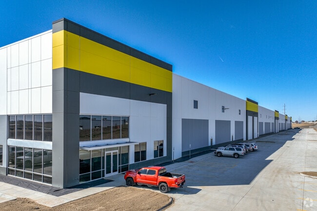
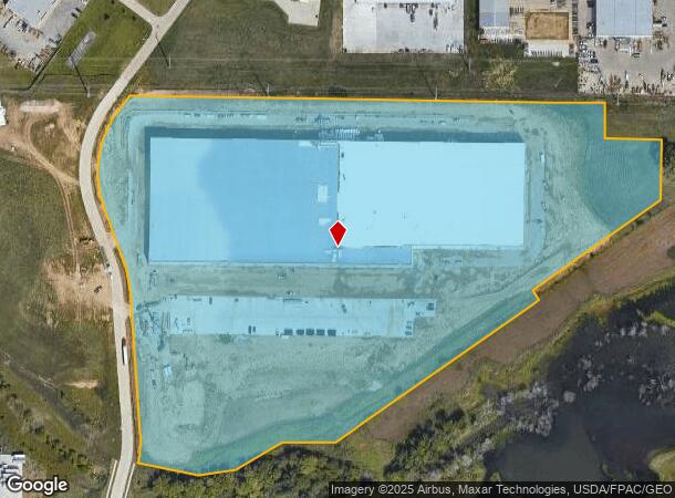
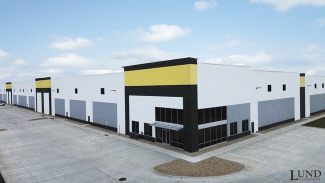
9009 S 135Th St
Omaha/Council Bluffs
I-80 Logistics Hub Replat 2
Omaha-Council Bluffs, NE-IA
LOT 1 I-80 LOGISTICS HUB REPLAT 2 (23.991 AC)
011616090
Sarpy
Industrialgeneral
Nebraska
2024
1
2025
23.99 AC
010629
Sarpy West
DEMOGRAPHICS near 9009 S 135Th St
1 Mile
3 Mile
5 Mile
2024 Total Population
2,023
50,616
161,083
2029 Population
2,184
53,086
168,270
Pop Growth 2024-2029
+ 7.96%
+ 4.88%
+ 4.46%
Average Age
37
37
38
2024 Total Households
822
19,533
61,840
HH Growth 2024-2029
+ 8.27%
+ 5.02%
+ 4.39%
Median Household Inc
$69,818
$85,171
$88,190
Avg Household Size
2.40
2.50
2.50
2024 Avg HH Vehicles
2.00
2.00
2.00
Median Home Value
$161,302
$232,936
$253,848
Median Year Built
1986
1990
1989
Nearby Places
Map Layers
Map Styles
 Street
 Aerial
- Restaurants
- Banks
- Shops
- Fitness
- Groceries
PUBLIC TRANSPORTATION
AIRPORT
Eppley Airfield
DRIVE
WALK
Distance
Eppley Airfield
31 min
19.2 mi
Freight Ports
Tulsa Port Of Catoosa
DRIVE
WALK
Distance
Tulsa Port Of Catoosa
471 min
421.5 mi
SALE & LEASE HISTORY
LISTING DATE
SALE/LEASE

Sep 30, 2022
For Lease
Sep 20, 2023
For Lease
Jan 31, 2022
For Lease
Dec 08, 2025
For Lease
Nearby Properties
Address
Land Use
TOTAL SIZE
Lot Size
Zoning
Address
Land Use
TOTAL SIZE
Lot Size
Zoning
94.11 AC
Address
Land Use
TOTAL SIZE
Lot Size
Zoning
2,400 SF
21.27 AC
Address
Land Use
TOTAL SIZE
Lot Size
Zoning
3,654 SF
39.62 AC
Address
Land Use
TOTAL SIZE
Lot Size
Zoning
543,301 SF
2.30 AC
IL
Address
Land Use
TOTAL SIZE
Lot Size
Zoning
370,890 SF
11.20 AC
CC
Address
Land Use
TOTAL SIZE
Lot Size
Zoning
599,779 SF
46.87 AC
I1
Address
Land Use
TOTAL SIZE
Lot Size
Zoning
315,685 SF
21.57 AC
RG10
Address
Land Use
TOTAL SIZE
Lot Size
Zoning
56,174 SF
8.65 AC
Address
Land Use
TOTAL SIZE
Lot Size
Zoning
252,985 SF
6.53 AC
Address
Land Use
TOTAL SIZE
Lot Size
Zoning
317,277 SF
20.12 AC
Address
Land Use
TOTAL SIZE
Lot Size
Zoning
9,600 SF
2.07 AC
IL
Address
Land Use
TOTAL SIZE
Lot Size
Zoning
8.10 AC
Address
Land Use
TOTAL SIZE
Lot Size
Zoning
46,886 SF
19.29 AC
Address
Land Use
TOTAL SIZE
Lot Size
Zoning
17.40 AC
Address
Land Use
TOTAL SIZE
Lot Size
Zoning
22.05 AC
Address
Land Use
TOTAL SIZE
Lot Size
Zoning
85,632 SF
5.69 AC
Address
Land Use
TOTAL SIZE
Lot Size
Zoning
24,294 SF
25.79 AC
Address
Land Use
TOTAL SIZE
Lot Size
Zoning
23,890 SF
14.34 AC
I2
Address
Land Use
TOTAL SIZE
Lot Size
Zoning
183,184 SF
20.66 AC
Address
Land Use
TOTAL SIZE
Lot Size
Zoning
56,150 SF
28.48 AC
Address
Land Use
TOTAL SIZE
Lot Size
Zoning
240,122 SF
10.16 AC
Address
Land Use
TOTAL SIZE
Lot Size
Zoning
210,585 SF
142.28 AC
I2
Address
Land Use
TOTAL SIZE
Lot Size
Zoning
16.57 AC
Address
Land Use
TOTAL SIZE
Lot Size
Zoning
250,999 SF
17.10 AC
Address
Land Use
TOTAL SIZE
Lot Size
Zoning
250,999 SF
15.44 AC
Address
Land Use
TOTAL SIZE
Lot Size
Zoning
258,637 SF
24.30 AC
Address
Land Use
TOTAL SIZE
Lot Size
Zoning
6,210 SF
8.28 AC
Address
Land Use
TOTAL SIZE
Lot Size
Zoning
120,500 SF
12.05 AC
IL
Address
Land Use
TOTAL SIZE
Lot Size
Zoning
201,293 SF
4.71 AC
The World's #1 Commercial Real Estate Marketplace
Connect with us
© 2026 CoStar Group
The information above has been obtained from sources believed reliable. While we do not doubt its accuracy we have not verified it and make no guarantee, warranty or representation about it. It is your responsibility to independently confirm its accuracy and completeness. Any projections, opinions, assumptions, or estimates used are for example only and do not represent the current or future performance of the property. The value of this transaction to you depends on tax and other factors which should be evaluated by your tax, financial, and legal advisors. You and your advisors should conduct a careful, independent investigation of the property to determine to your satisfaction the suitability of the property for your needs.