Property Record
900R S Main St, Torrington, CT 06790
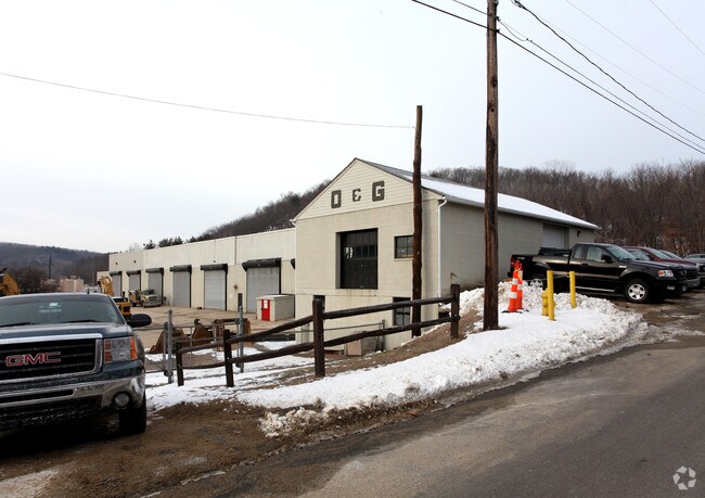

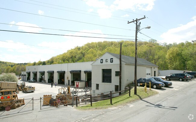
Property Detail
900R S Main St
Torrington, CT
LITCHFIELD
TORR-000235-000001-000004
Connecticut
Commercialnec
4
I
6 AC
2024
Torrington
2025
Hartford
310801
NEARBY LISTINGS FOR SALE OR LEASE
DEMOGRAPHICS near 900R S Main St
1 mile
3 mile
5 mile
2025 Total Population
2,298
29,019
40,538
2030 Population
2,294
29,072
40,641
Pop Growth 2025-2030
(0.17%)
+ 0.18%
+ 0.25%
Average Age
41
43
44
2025 Total Households
1,001
12,738
17,513
HH Growth 2025-2030
(0.20%)
+ 0.22%
+ 0.30%
Median Household Inc
$66,835
$68,294
$74,512
Avg Household Size
2.20
2.20
2.20
2025 Avg HH Vehicles
2.00
2.00
2.00
Median Home Value
$220,325
$212,417
$240,153
Median Year Built
1947
1954
1959
Nearby Places
Map Layers
Map Styles
 Street
 Aerial
Layers
 Traffic
 Biking
Places
Listings with unknown addresses are not visible on the map
- Restaurants
- Banks
- Shops
- Fitness
- Groceries
PUBLIC TRANSPORTATION
AIRPORT
Bradley International
Drive
Walk
Distance
Bradley International
61 min
35.3 mi
Freight Ports
Port of New Haven
Drive
Walk
Distance
Port of New Haven
62 min
42.8 mi
Nearby Properties
Address
Land Use
TOTAL SIZE
Lot Size
Zoning
Address
Land Use
TOTAL SIZE
Lot Size
Zoning
119.90 AC
R6
Address
Land Use
TOTAL SIZE
Lot Size
Zoning
169,551 SF
3.49 AC
I
Address
Land Use
TOTAL SIZE
Lot Size
Zoning
86,780 SF
4.78 AC
R6
Address
Land Use
TOTAL SIZE
Lot Size
Zoning
85,628 SF
4.25 AC
R6
Address
Land Use
TOTAL SIZE
Lot Size
Zoning
142,840 SF
13.80 AC
R6
Address
Land Use
TOTAL SIZE
Lot Size
Zoning
111,459 SF
16.72 AC
R15
Address
Land Use
TOTAL SIZE
Lot Size
Zoning
20,365 SF
18.92 AC
R15S
Address
Land Use
TOTAL SIZE
Lot Size
Zoning
13,576 SF
12.80 AC
R10
Address
Land Use
TOTAL SIZE
Lot Size
Zoning
15.03 AC
DD
Address
Land Use
TOTAL SIZE
Lot Size
Zoning
42,676 SF
3.19 AC
R6
Address
Land Use
TOTAL SIZE
Lot Size
Zoning
58.50 AC
RR
Address
Land Use
TOTAL SIZE
Lot Size
Zoning
39,111 SF
0.63 AC
DD-R
Address
Land Use
TOTAL SIZE
Lot Size
Zoning
396.22 AC
R-1
Address
Land Use
TOTAL SIZE
Lot Size
Zoning
68,013 SF
9.83 AC
R10S
Address
Land Use
TOTAL SIZE
Lot Size
Zoning
124,360 SF
4.30 AC
DD
Address
Land Use
TOTAL SIZE
Lot Size
Zoning
68,192 SF
1.76 AC
DD
Address
Land Use
TOTAL SIZE
Lot Size
Zoning
131,925 SF
12.51 AC
DD
Address
Land Use
TOTAL SIZE
Lot Size
Zoning
15.80 AC
R6
Address
Land Use
TOTAL SIZE
Lot Size
Zoning
24,768 SF
1.67 AC
DD
Address
Land Use
TOTAL SIZE
Lot Size
Zoning
3.90 AC
B1
Address
Land Use
TOTAL SIZE
Lot Size
Zoning
75,562 SF
7.32 AC
R15S
Address
Land Use
TOTAL SIZE
Lot Size
Zoning
68,160 SF
2.31 AC
LB
Address
Land Use
TOTAL SIZE
Lot Size
Zoning
165,290 SF
19.10 AC
LB
Address
Land Use
TOTAL SIZE
Lot Size
Zoning
7,200 SF
0.27 AC
DD
Address
Land Use
TOTAL SIZE
Lot Size
Zoning
1 AC
DD
Address
Land Use
TOTAL SIZE
Lot Size
Zoning
5.30 AC
R6
Address
Land Use
TOTAL SIZE
Lot Size
Zoning
4.70 AC
I
Address
Land Use
TOTAL SIZE
Lot Size
Zoning
59,670 SF
4.31 AC
R6
Address
Land Use
TOTAL SIZE
Lot Size
Zoning
57,875 SF
21.83 AC
CRA-2
Address
Land Use
TOTAL SIZE
Lot Size
Zoning
31,476 SF
3.09 AC
I
The World's #1 Commercial Real Estate Marketplace
Connect with us
© 2026 CoStar Group
The information above has been obtained from sources believed reliable. While we do not doubt its accuracy we have not verified it and make no guarantee, warranty or representation about it. It is your responsibility to independently confirm its accuracy and completeness. Any projections, opinions, assumptions, or estimates used are for example only and do not represent the current or future performance of the property. The value of this transaction to you depends on tax and other factors which should be evaluated by your tax, financial, and legal advisors. You and your advisors should conduct a careful, independent investigation of the property to determine to your satisfaction the suitability of the property for your needs.