No Photo
Property Record
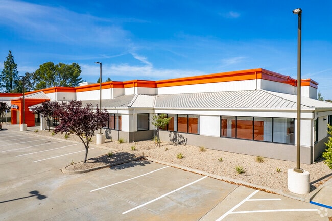
901 Arnold Dr, Martinez, CA 94553


Property Detail
901 Arnold Dr
377-170-014-7
PARCEL MAP 15 PG 29 POR PCL A
Publicstorage
CONTRA COSTA
B and X Area of moderate flood hazard, usually the area between the limits of the 100-year and 500-year floods.
California
2025
2.06 AC
2025
Martinez/Pacheco/Hercules
320003
East Bay/Oakland
78,762 SF
Oakland-Fremont-Berkeley, CA
NEARBY LISTINGS FOR SALE OR LEASE
-
-
View all Martinez listings for sale on LoopNet.com
DEMOGRAPHICS near 901 Arnold Dr
1 mile
3 mile
5 mile
2025 Total Population
15,353
57,598
139,545
2030 Population
15,487
57,920
140,371
Pop Growth 2025-2030
+ 0.87%
+ 0.56%
+ 0.59%
Average Age
41
43
42
2025 Total Households
6,026
22,706
53,426
HH Growth 2025-2030
+ 0.91%
+ 0.63%
+ 0.66%
Median Household Inc
$127,565
$122,918
$115,207
Avg Household Size
2.50
2.50
2.50
2025 Avg HH Vehicles
2.00
2.00
2.00
Median Home Value
$767,120
$779,651
$794,920
Median Year Built
1980
1976
1972
Nearby Places
Map Layers
Map Styles
 Street
 Aerial
Transit
 Traffic
 Biking
Places
Listings with unknown addresses are not visible on the map
- Restaurants
- Banks
- Shops
- Fitness
- Groceries
PUBLIC TRANSPORTATION
COMMUTER RAIL
Drive
Walk
Distance
7 min
2.7 mi
AIRPORT
Metro Oakland International
Drive
Walk
Distance
Metro Oakland International
47 min
33.6 mi
San Francisco International
Drive
Walk
Distance
San Francisco International
61 min
45.0 mi
Nearby Properties
Address
Land Use
TOTAL SIZE
Lot Size
Zoning
Address
Land Use
TOTAL SIZE
Lot Size
Zoning
228,197 SF
294.92 AC
HI
Address
Land Use
TOTAL SIZE
Lot Size
Zoning
28,948 SF
63.56 AC
HI
Address
Land Use
TOTAL SIZE
Lot Size
Zoning
9,000 SF
137.45 AC
Address
Land Use
TOTAL SIZE
Lot Size
Zoning
25,089 SF
57.67 AC
HI
Address
Land Use
TOTAL SIZE
Lot Size
Zoning
12.82 AC
Address
Land Use
TOTAL SIZE
Lot Size
Zoning
187,998 SF
135.96 AC
Address
Land Use
TOTAL SIZE
Lot Size
Zoning
66,196 SF
40.92 AC
HI
Address
Land Use
TOTAL SIZE
Lot Size
Zoning
54,870 SF
34.53 AC
HI
Address
Land Use
TOTAL SIZE
Lot Size
Zoning
234,624 SF
6.63 AC
Address
Land Use
TOTAL SIZE
Lot Size
Zoning
70,000 SF
25.77 AC
Address
Land Use
TOTAL SIZE
Lot Size
Zoning
112,000 SF
18.40 AC
Address
Land Use
TOTAL SIZE
Lot Size
Zoning
9,840 SF
5.85 AC
Address
Land Use
TOTAL SIZE
Lot Size
Zoning
15.34 AC
Address
Land Use
TOTAL SIZE
Lot Size
Zoning
66.32 AC
Address
Land Use
TOTAL SIZE
Lot Size
Zoning
68.97 AC
Address
Land Use
TOTAL SIZE
Lot Size
Zoning
7.08 AC
Address
Land Use
TOTAL SIZE
Lot Size
Zoning
49,519 SF
2.04 AC
Address
Land Use
TOTAL SIZE
Lot Size
Zoning
3.07 AC
Address
Land Use
TOTAL SIZE
Lot Size
Zoning
71,000 SF
1.23 AC
Address
Land Use
TOTAL SIZE
Lot Size
Zoning
196.06 AC
HI
Address
Land Use
TOTAL SIZE
Lot Size
Zoning
3,612 SF
4.74 AC
Address
Land Use
TOTAL SIZE
Lot Size
Zoning
22.30 AC
Address
Land Use
TOTAL SIZE
Lot Size
Zoning
51,500 SF
5.92 AC
Address
Land Use
TOTAL SIZE
Lot Size
Zoning
17,758 SF
9.95 AC
Address
Land Use
TOTAL SIZE
Lot Size
Zoning
93,942 SF
6.29 AC
Address
Land Use
TOTAL SIZE
Lot Size
Zoning
13.74 AC
HI
Address
Land Use
TOTAL SIZE
Lot Size
Zoning
2,318 SF
4.13 AC
CM
Address
Land Use
TOTAL SIZE
Lot Size
Zoning
32,928 SF
7.56 AC
Address
Land Use
TOTAL SIZE
Lot Size
Zoning
126,248 SF
3.34 AC
Address
Land Use
TOTAL SIZE
Lot Size
Zoning
12,656 SF
5.34 AC
The World's #1 Commercial Real Estate Marketplace
Connect with us
© 2026 CoStar Group
The information above has been obtained from sources believed reliable. While we do not doubt its accuracy we have not verified it and make no guarantee, warranty or representation about it. It is your responsibility to independently confirm its accuracy and completeness. Any projections, opinions, assumptions, or estimates used are for example only and do not represent the current or future performance of the property. The value of this transaction to you depends on tax and other factors which should be evaluated by your tax, financial, and legal advisors. You and your advisors should conduct a careful, independent investigation of the property to determine to your satisfaction the suitability of the property for your needs.