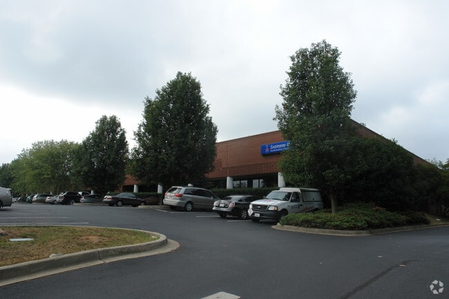
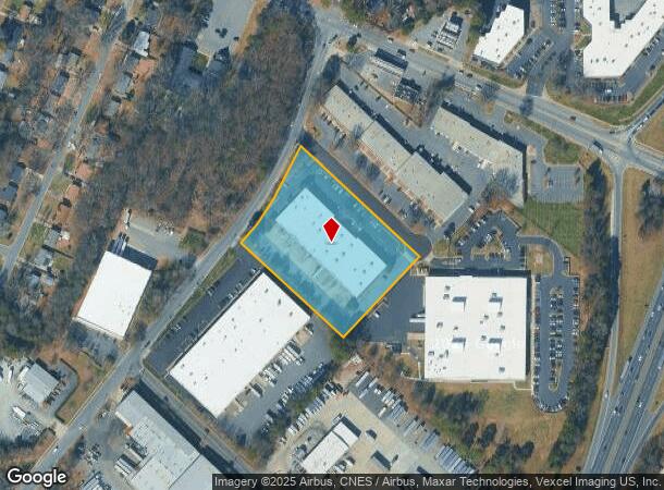
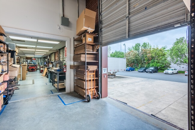
Property Record
901 Blairhill Rd, Charlotte, NC 28217

Current Lease Availabilities
NEARBY LISTINGS FOR SALE OR LEASE
Property Detail
901 Blairhill Rd
Charlotte-Concord-Gastonia, NC-SC
On A/Blairhill A
145-321-11
TR A M23-507
Industrialgeneral
Mecklenburg
X
North Carolina
3710453300K
11
2024
3.27 AC
2025
Tyvola Rd
003802
Charlotte
43,427 SF
DEMOGRAPHICS near 901 Blairhill Rd
1 Mile
3 Mile
5 Mile
2024 Total Population
7,227
87,753
234,612
2029 Population
7,655
93,889
250,597
Pop Growth 2024-2029
+ 5.92%
+ 6.99%
+ 6.81%
Average Age
37
35
36
2024 Total Households
2,998
43,984
109,203
HH Growth 2024-2029
+ 5.90%
+ 7.14%
+ 6.98%
Median Household Inc
$38,088
$75,947
$73,005
Avg Household Size
2.30
1.90
2.10
2024 Avg HH Vehicles
2.00
1.00
1.00
Median Home Value
$211,905
$420,760
$401,833
Median Year Built
1966
2001
1995
Nearby Places
- Restaurants
- Banks
- Shops
- Fitness
- Groceries
PUBLIC TRANSPORTATION
AIRPORT
Charlotte/Douglas International
DRIVE
WALK
Distance
Charlotte/Douglas International
13 min
5.6 mi
Concord-Padgett Regional
DRIVE
WALK
Distance
Concord-Padgett Regional
29 min
19.6 mi
Nearby Properties
Address
Land Use
TOTAL SIZE
Lot Size
Zoning
Address
Land Use
TOTAL SIZE
Lot Size
Zoning
3,286,640 SF
55.70 AC
O6CD
Address
Land Use
TOTAL SIZE
Lot Size
Zoning
5,290,257 SF
502.52 AC
I2
Address
Land Use
TOTAL SIZE
Lot Size
Zoning
1,652,470 SF
10.96 AC
UMUD
Address
Land Use
TOTAL SIZE
Lot Size
Zoning
1,498,190 SF
2.09 AC
UMUD
Address
Land Use
TOTAL SIZE
Lot Size
Zoning
1,483,634 SF
1.49 AC
Address
Land Use
TOTAL SIZE
Lot Size
Zoning
925,808 SF
1.84 AC
UMUD-O
Address
Land Use
TOTAL SIZE
Lot Size
Zoning
1,435,616 SF
33.78 AC
UMUD
Address
Land Use
TOTAL SIZE
Lot Size
Zoning
1,250,926 SF
4.89 AC
I2
Address
Land Use
TOTAL SIZE
Lot Size
Zoning
582,357 SF
1.13 AC
MUDD-O
Address
Land Use
TOTAL SIZE
Lot Size
Zoning
894,108 SF
4.52 AC
UMUDO
Address
Land Use
TOTAL SIZE
Lot Size
Zoning
696,527 SF
1.96 AC
UMUDO
Address
Land Use
TOTAL SIZE
Lot Size
Zoning
1,025,674 SF
3.43 AC
UMUD
Address
Land Use
TOTAL SIZE
Lot Size
Zoning
626,053 SF
2.77 AC
I2
Address
Land Use
TOTAL SIZE
Lot Size
Zoning
416,225 SF
0.64 AC
Address
Land Use
TOTAL SIZE
Lot Size
Zoning
1,519,630 SF
235.59 AC
I2
Address
Land Use
TOTAL SIZE
Lot Size
Zoning
645,212 SF
3.76 AC
UMUD
Address
Land Use
TOTAL SIZE
Lot Size
Zoning
680,348 SF
0.94 AC
Address
Land Use
TOTAL SIZE
Lot Size
Zoning
766,215 SF
1.17 AC
UMUD
Address
Land Use
TOTAL SIZE
Lot Size
Zoning
743,550 SF
4.69 AC
I2
Address
Land Use
TOTAL SIZE
Lot Size
Zoning
505,747 SF
3.87 AC
Address
Land Use
TOTAL SIZE
Lot Size
Zoning
639,406 SF
2.76 AC
TOD-UC
Address
Land Use
TOTAL SIZE
Lot Size
Zoning
689,165 SF
1.30 AC
Address
Land Use
TOTAL SIZE
Lot Size
Zoning
507,814 SF
5.26 AC
UMUD
Address
Land Use
TOTAL SIZE
Lot Size
Zoning
693,089 SF
1.81 AC
MUDDO
Address
Land Use
TOTAL SIZE
Lot Size
Zoning
838,508 SF
4.25 AC
UMUD
Address
Land Use
TOTAL SIZE
Lot Size
Zoning
187,366 SF
4.06 AC
TOD-UC
Address
Land Use
TOTAL SIZE
Lot Size
Zoning
440,554 SF
5.26 AC
UMUD
Address
Land Use
TOTAL SIZE
Lot Size
Zoning
581,470 SF
2.55 AC
I2
Address
Land Use
TOTAL SIZE
Lot Size
Zoning
490,957 SF
4.32 AC
I2
Address
Land Use
TOTAL SIZE
Lot Size
Zoning
412,104 SF
1.13 AC
UMUDO
The World's #1 Commercial Real Estate Marketplace
Connect with us
© 2025 CoStar Group
The information above has been obtained from sources believed reliable. While we do not doubt its accuracy we have not verified it and make no guarantee, warranty or representation about it. It is your responsibility to independently confirm its accuracy and completeness. Any projections, opinions, assumptions, or estimates used are for example only and do not represent the current or future performance of the property. The value of this transaction to you depends on tax and other factors which should be evaluated by your tax, financial, and legal advisors. You and your advisors should conduct a careful, independent investigation of the property to determine to your satisfaction the suitability of the property for your needs.