Property Record
901 E Elmwood Ave, Beloit, WI 53511

Save to a Folder
{{folder.Name}}
{{folder.ListingIds.length}} Properties
{{folder.ListingIds.length}} Property
Create a New Folder
Property Detail
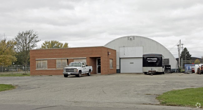
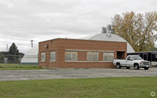
901 E Elmwood Ave
Janesville-Beloit, WI
PT SW1/4 CRESTVIEW W 375' LOT 90
626-9291A
ROCK
Officebuilding
Wisconsin
B and X Area of moderate flood hazard, usually the area between the limits of the 100-year and 500-year floods.
90
2025
3.65 AC
2025
Rock County
002400
Milwaukee/Madison
839 SF
NEARBY LISTINGS FOR SALE OR LEASE
DEMOGRAPHICS near 901 E Elmwood Ave
1 mile
3 mile
5 mile
2025 Total Population
5,897
38,728
58,157
2030 Population
5,946
39,006
58,759
Pop Growth 2025-2030
+ 0.83%
+ 0.72%
+ 1.04%
Average Age
43
40
40
2025 Total Households
2,538
15,155
22,808
HH Growth 2025-2030
+ 0.79%
+ 0.74%
+ 1.05%
Median Household Inc
$71,355
$61,473
$65,869
Avg Household Size
2.30
2.40
2.40
2025 Avg HH Vehicles
2.00
2.00
2.00
Median Home Value
$199,177
$181,630
$182,072
Median Year Built
1970
1959
1964
Nearby Places
Map Layers
Map Styles
 Street
 Aerial
Layers
 Traffic
 Biking
Places
Listings with unknown addresses are not visible on the map
- Restaurants
- Banks
- Shops
- Fitness
- Groceries
PUBLIC TRANSPORTATION
AIRPORT
Chicago/Rockford International
Drive
Walk
Distance
Chicago/Rockford International
49 min
34.9 mi
Nearby Properties
Address
Land Use
TOTAL SIZE
Lot Size
Zoning
Address
Land Use
TOTAL SIZE
Lot Size
Zoning
264,000 SF
34 AC
Address
Land Use
TOTAL SIZE
Lot Size
Zoning
37.49 AC
CHI
Address
Land Use
TOTAL SIZE
Lot Size
Zoning
24.76 AC
Address
Land Use
TOTAL SIZE
Lot Size
Zoning
202,676 SF
19.31 AC
Address
Land Use
TOTAL SIZE
Lot Size
Zoning
61,820 SF
5.63 AC
Address
Land Use
TOTAL SIZE
Lot Size
Zoning
103,761 SF
21.59 AC
Address
Land Use
TOTAL SIZE
Lot Size
Zoning
7.71 AC
Address
Land Use
TOTAL SIZE
Lot Size
Zoning
186,691 SF
17.06 AC
Address
Land Use
TOTAL SIZE
Lot Size
Zoning
3.39 AC
Address
Land Use
TOTAL SIZE
Lot Size
Zoning
3.47 AC
Address
Land Use
TOTAL SIZE
Lot Size
Zoning
3.65 AC
Address
Land Use
TOTAL SIZE
Lot Size
Zoning
13.21 AC
Address
Land Use
TOTAL SIZE
Lot Size
Zoning
231,166 SF
19.25 AC
Address
Land Use
TOTAL SIZE
Lot Size
Zoning
361,947 SF
23.26 AC
Address
Land Use
TOTAL SIZE
Lot Size
Zoning
24.15 AC
Address
Land Use
TOTAL SIZE
Lot Size
Zoning
193,013 SF
22.93 AC
Address
Land Use
TOTAL SIZE
Lot Size
Zoning
38,012 SF
2.74 AC
Address
Land Use
TOTAL SIZE
Lot Size
Zoning
40,800 SF
81.29 AC
Address
Land Use
TOTAL SIZE
Lot Size
Zoning
27.69 AC
Address
Land Use
TOTAL SIZE
Lot Size
Zoning
9,208 SF
10.33 AC
Address
Land Use
TOTAL SIZE
Lot Size
Zoning
30,000 SF
3.31 AC
Address
Land Use
TOTAL SIZE
Lot Size
Zoning
101,660 SF
10.14 AC
Address
Land Use
TOTAL SIZE
Lot Size
Zoning
16,336 SF
9.06 AC
Address
Land Use
TOTAL SIZE
Lot Size
Zoning
3.30 AC
Address
Land Use
TOTAL SIZE
Lot Size
Zoning
32.79 AC
Address
Land Use
TOTAL SIZE
Lot Size
Zoning
89,678 SF
12.90 AC
Address
Land Use
TOTAL SIZE
Lot Size
Zoning
20.18 AC
Address
Land Use
TOTAL SIZE
Lot Size
Zoning
296,731 SF
18.14 AC
Address
Land Use
TOTAL SIZE
Lot Size
Zoning
90,285 SF
4.24 AC
Address
Land Use
TOTAL SIZE
Lot Size
Zoning
95,546 SF
8.60 AC
The World's #1 Commercial Real Estate Marketplace
Connect with us
© 2026 CoStar Group
The information above has been obtained from sources believed reliable. While we do not doubt its accuracy we have not verified it and make no guarantee, warranty or representation about it. It is your responsibility to independently confirm its accuracy and completeness. Any projections, opinions, assumptions, or estimates used are for example only and do not represent the current or future performance of the property. The value of this transaction to you depends on tax and other factors which should be evaluated by your tax, financial, and legal advisors. You and your advisors should conduct a careful, independent investigation of the property to determine to your satisfaction the suitability of the property for your needs.