Property Record
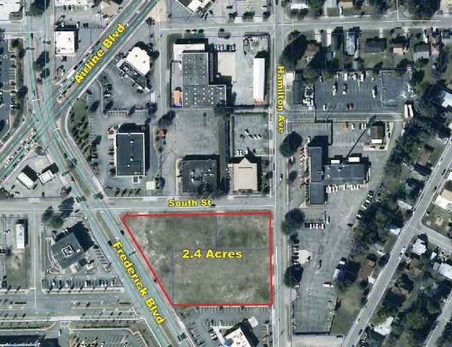
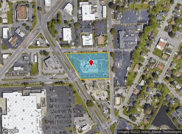
901 Frederick Blvd, Portsmouth, VA 23707
NEARBY LISTINGS FOR SALE OR LEASE
Property Detail
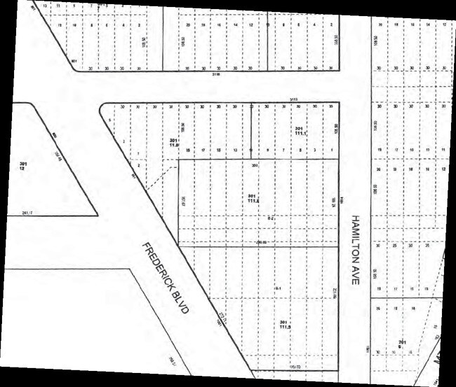
901 Frederick Blvd
0301-0118
Commercial District 5
Restaurantdrivein
LTS & ST SE INCT FRDRCK&SOUTH
X
Portsmouth
5155290079D
Virginia
2024
2.40 AC
2025
Portsmouth
211500
Hampton Roads
4,943 SF
Virginia Beach-Norfolk-Newport News, VA-NC
DEMOGRAPHICS near 901 Frederick Blvd
1 Mile
3 Mile
5 Mile
2024 Total Population
12,985
82,557
229,049
2029 Population
12,967
82,304
229,938
Pop Growth 2024-2029
(0.14%)
(0.31%)
+ 0.39%
Average Age
37
38
37
2024 Total Households
5,317
34,476
90,464
HH Growth 2024-2029
(0.19%)
(0.39%)
+ 0.18%
Median Household Inc
$43,912
$55,589
$59,276
Avg Household Size
2.40
2.30
2.40
2024 Avg HH Vehicles
1.00
2.00
2.00
Median Home Value
$170,318
$192,190
$232,857
Median Year Built
1957
1962
1970
Nearby Places
Map Layers
Map Styles
 Street
 Aerial
- Restaurants
- Banks
- Shops
- Fitness
- Groceries
PUBLIC TRANSPORTATION
COMMUTER RAIL
DRIVE
WALK
Distance
10 min
5.0 mi
AIRPORT
Norfolk International
DRIVE
WALK
Distance
Norfolk International
22 min
11.4 mi
Newport News/Williamsburg International
DRIVE
WALK
Distance
Newport News/Williamsburg International
46 min
32.5 mi
Freight Ports
Virginia Port Authority - Portsmouth
DRIVE
WALK
Distance
Virginia Port Authority - Portsmouth
10 min
3.4 mi
Nearby Properties
Address
Land Use
TOTAL SIZE
Lot Size
Zoning
Address
Land Use
TOTAL SIZE
Lot Size
Zoning
331,760 SF
24.97 AC
Address
Land Use
TOTAL SIZE
Lot Size
Zoning
250,000 SF
38 AC
MUH
Address
Land Use
TOTAL SIZE
Lot Size
Zoning
300,829 SF
38.40 AC
IL
Address
Land Use
TOTAL SIZE
Lot Size
Zoning
85,756 SF
3.59 AC
D5
Address
Land Use
TOTAL SIZE
Lot Size
Zoning
421,540 SF
2.37 AC
Address
Land Use
TOTAL SIZE
Lot Size
Zoning
250,766 SF
31.14 AC
NMU
Address
Land Use
TOTAL SIZE
Lot Size
Zoning
390,960 SF
4.43 AC
Address
Land Use
TOTAL SIZE
Lot Size
Zoning
310,912 SF
3.94 AC
Address
Land Use
TOTAL SIZE
Lot Size
Zoning
473,072 SF
9.72 AC
SD
Address
Land Use
TOTAL SIZE
Lot Size
Zoning
192,270 SF
1.99 AC
D2
Address
Land Use
TOTAL SIZE
Lot Size
Zoning
363,974 SF
1.49 AC
Address
Land Use
TOTAL SIZE
Lot Size
Zoning
66,718 SF
4.09 AC
D5
Address
Land Use
TOTAL SIZE
Lot Size
Zoning
160,677 SF
29.47 AC
IN
Address
Land Use
TOTAL SIZE
Lot Size
Zoning
50,384 SF
0.74 AC
Address
Land Use
TOTAL SIZE
Lot Size
Zoning
406,344 SF
8.45 AC
GMU
Address
Land Use
TOTAL SIZE
Lot Size
Zoning
35,091 SF
0.71 AC
Address
Land Use
TOTAL SIZE
Lot Size
Zoning
130,750 SF
68.79 AC
IN
Address
Land Use
TOTAL SIZE
Lot Size
Zoning
608,074 SF
0.60 AC
Address
Land Use
TOTAL SIZE
Lot Size
Zoning
254,194 SF
1.93 AC
D3
Address
Land Use
TOTAL SIZE
Lot Size
Zoning
56,217 SF
1.31 AC
Address
Land Use
TOTAL SIZE
Lot Size
Zoning
251,984 SF
0.40 AC
D2
Address
Land Use
TOTAL SIZE
Lot Size
Zoning
13,415 SF
122.41 AC
Address
Land Use
TOTAL SIZE
Lot Size
Zoning
199,530 SF
2.56 AC
IN2
Address
Land Use
TOTAL SIZE
Lot Size
Zoning
5 AC
D1
Address
Land Use
TOTAL SIZE
Lot Size
Zoning
210,897 SF
2.12 AC
IN2
Address
Land Use
TOTAL SIZE
Lot Size
Zoning
563,325 SF
0.72 AC
D2
Address
Land Use
TOTAL SIZE
Lot Size
Zoning
13,415 SF
82.02 AC
Address
Land Use
TOTAL SIZE
Lot Size
Zoning
237,629 SF
2.65 AC
T6
Address
Land Use
TOTAL SIZE
Lot Size
Zoning
269,796 SF
1.16 AC
IN2
Address
Land Use
TOTAL SIZE
Lot Size
Zoning
337,760 SF
5.12 AC
D4
The World's #1 Commercial Real Estate Marketplace
Connect with us
© 2025 CoStar Group
The information above has been obtained from sources believed reliable. While we do not doubt its accuracy we have not verified it and make no guarantee, warranty or representation about it. It is your responsibility to independently confirm its accuracy and completeness. Any projections, opinions, assumptions, or estimates used are for example only and do not represent the current or future performance of the property. The value of this transaction to you depends on tax and other factors which should be evaluated by your tax, financial, and legal advisors. You and your advisors should conduct a careful, independent investigation of the property to determine to your satisfaction the suitability of the property for your needs.