Property Record
901 Pace Bend Rd S, Spicewood, TX 78669
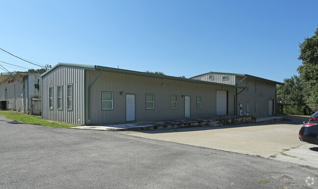

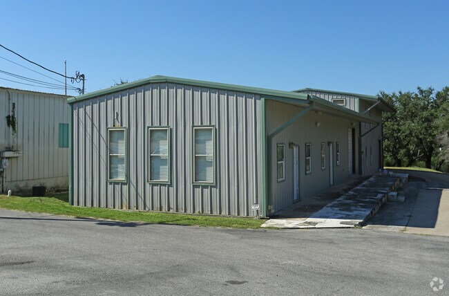
Property Detail
901 Pace Bend Rd S
356286
ABS 2455 SUR 512 BAILEY T B ACR 67.652 (1-D-1)
Farms
Travis
B and X Area of moderate flood hazard, usually the area between the limits of the 100-year and 500-year floods.
Texas
2025
67.65 AC
2025
Southwest
035300
Austin
1,780 SF
Austin-Round Rock-San Marcos, TX
NEARBY LISTINGS FOR SALE OR LEASE
-
-
View all Spicewood listings for lease on LoopNet.com
DEMOGRAPHICS near 901 Pace Bend Rd S
1 mile
3 mile
5 mile
2025 Total Population
1,864
8,269
27,912
2030 Population
1,967
8,976
30,344
Pop Growth 2025-2030
+ 5.53%
+ 8.55%
+ 8.71%
Average Age
44
46
46
2025 Total Households
709
3,338
11,023
HH Growth 2025-2030
+ 6.21%
+ 9.38%
+ 9.48%
Median Household Inc
$136,363
$122,355
$139,873
Avg Household Size
2.60
2.50
2.50
2025 Avg HH Vehicles
2.00
2.00
2.00
Median Home Value
$627,245
$703,347
$715,525
Median Year Built
2005
2006
2008
Nearby Places
Map Layers
Map Styles
 Street
 Aerial
Transit
 Traffic
 Biking
Places
Listings with unknown addresses are not visible on the map
- Restaurants
- Banks
- Shops
- Fitness
- Groceries
PUBLIC TRANSPORTATION
AIRPORT
Austin-Bergstrom International
Drive
Walk
Distance
Austin-Bergstrom International
56 min
35.5 mi
Freight Ports
Calhoun Port
Drive
Walk
Distance
Calhoun Port
221 min
179.0 mi
SALE & LEASE HISTORY
LISTING DATE
SALE/LEASE

Jun 04, 2020
For Lease
Nearby Properties
Address
Land Use
TOTAL SIZE
Lot Size
Zoning
Address
Land Use
TOTAL SIZE
Lot Size
Zoning
391.25 AC
Address
Land Use
TOTAL SIZE
Lot Size
Zoning
76,000 SF
6.50 AC
Address
Land Use
TOTAL SIZE
Lot Size
Zoning
482.92 AC
Address
Land Use
TOTAL SIZE
Lot Size
Zoning
12,592 SF
24.61 AC
Address
Land Use
TOTAL SIZE
Lot Size
Zoning
48.23 AC
Address
Land Use
TOTAL SIZE
Lot Size
Zoning
12,693 SF
2 AC
Address
Land Use
TOTAL SIZE
Lot Size
Zoning
25,200 SF
10 AC
Address
Land Use
TOTAL SIZE
Lot Size
Zoning
13.95 AC
Address
Land Use
TOTAL SIZE
Lot Size
Zoning
6,633 SF
33.94 AC
Address
Land Use
TOTAL SIZE
Lot Size
Zoning
34,339 SF
459.50 AC
Address
Land Use
TOTAL SIZE
Lot Size
Zoning
21,578 SF
8.50 AC
Address
Land Use
TOTAL SIZE
Lot Size
Zoning
22,333 SF
2.46 AC
Address
Land Use
TOTAL SIZE
Lot Size
Zoning
28.14 AC
Address
Land Use
TOTAL SIZE
Lot Size
Zoning
8,362 SF
55 AC
Address
Land Use
TOTAL SIZE
Lot Size
Zoning
2,352 SF
85.71 AC
Address
Land Use
TOTAL SIZE
Lot Size
Zoning
9,500 SF
12.12 AC
Address
Land Use
TOTAL SIZE
Lot Size
Zoning
8,047 SF
12.80 AC
Address
Land Use
TOTAL SIZE
Lot Size
Zoning
2,175 SF
47.40 AC
Address
Land Use
TOTAL SIZE
Lot Size
Zoning
72.58 AC
Address
Land Use
TOTAL SIZE
Lot Size
Zoning
37,056 SF
3.34 AC
Address
Land Use
TOTAL SIZE
Lot Size
Zoning
17.28 AC
Address
Land Use
TOTAL SIZE
Lot Size
Zoning
17,090 SF
110.36 AC
Address
Land Use
TOTAL SIZE
Lot Size
Zoning
7,129 SF
64.09 AC
Address
Land Use
TOTAL SIZE
Lot Size
Zoning
16,100 SF
2.01 AC
Address
Land Use
TOTAL SIZE
Lot Size
Zoning
6,809 SF
22.46 AC
Address
Land Use
TOTAL SIZE
Lot Size
Zoning
8,132 SF
12.16 AC
Address
Land Use
TOTAL SIZE
Lot Size
Zoning
1 SF
1.07 AC
Address
Land Use
TOTAL SIZE
Lot Size
Zoning
61.06 AC
Address
Land Use
TOTAL SIZE
Lot Size
Zoning
9,115 SF
108.79 AC
Address
Land Use
TOTAL SIZE
Lot Size
Zoning
6,565 SF
11.26 AC
The World's #1 Commercial Real Estate Marketplace
Connect with us
© 2026 CoStar Group
The information above has been obtained from sources believed reliable. While we do not doubt its accuracy we have not verified it and make no guarantee, warranty or representation about it. It is your responsibility to independently confirm its accuracy and completeness. Any projections, opinions, assumptions, or estimates used are for example only and do not represent the current or future performance of the property. The value of this transaction to you depends on tax and other factors which should be evaluated by your tax, financial, and legal advisors. You and your advisors should conduct a careful, independent investigation of the property to determine to your satisfaction the suitability of the property for your needs.